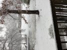
I’ve chased a fair number of snowstorms in the mid Atlantic over the past 10-15 years and this is by far the most impressive when it comes to limb destruction. Just pop pop with larger ones in the distance, we are about 500’ off SR 208 and you can not see the road out there, wind is still largely light but I expect that to change this afternoon.
-
Hello, please take a minute to check out our awesome content, contributed by the wonderful members of our community. We hope you'll add your own thoughts and opinions by making a free account!
You are using an out of date browser. It may not display this or other websites correctly.
You should upgrade or use an alternative browser.
You should upgrade or use an alternative browser.
Wintry Jan 2-4 2022 Winter Weather Event/Obs
- Thread starter SD
- Start date
Yep, the warm temps preceding this storm really kept the roads from being much of an issue there. That’s one of the biggest ways antecedent conditions can have a huge impact. Beautiful, though!View attachment 101544View attachment 101545
On my way to work, because of course we have 4" of snow, but the roads are fine.
The way things have been lately, I would consider anything besides cold rain a significant winter weather event for the area we live in.Never supposed to have any significant winter precip but a good band of snow and sleet look likely
tazaroo
Member
Finally ripping fatties here in Ramseur. 20 miles SE of Greensboro NC.
Temp 34
Temp 34
Heelyes
Member
Light rain ip mix
Flakes are falling now!
Yikes
MichaelJ
Member


Graupal is the name of the game here in apex and this band looks healthy enough to pull through when it should be all snow … happy new year everyone
Heelyes
Member
Im on 64 west and can see the snow coming
NBAcentel
Member
Puking snow
Rain. Pain. 37.
Heelyes
Member
7 miles west of pittsboro it's snowing
Bannerdude
Member
Back to rain in Moncure after the heavier returns moved past
Might be drizzling here but that’s all I’ve seen since I’ve been up. Unfortunately, I have to work today so I can’t pay 100% attention. ?
Here is some of the reports I found out around
The Carolinas and Tennessee.
Storm Reports:
North Carolina:
Seeing a report of 11" in Yancey Co at 4360' near Wolf Laurel (9am)
Beech Mountain didn't disappoint and it's still coming down. 23°F at 5500' 4 to 6 inches depending where you are.
• NC-197 (NC 197S), Near Ewart Wilson
• South of Burnsville / Both Directions
• Yancey County
Weather Event: Local Traffic Only
Approach to bridge on NC 197S washed out. Temporary bridge installed for local traffic only.
• NC-90 (W Main Ave), Near Old Wilkesboro Rd
• In Taylorsville / Both Directions
• Alexander County
Weather Event: Road Closed with Detour
NC 90 (W Main Ave) is closed and detoured in Taylorsville due to a downed utility pole and lines.
NC-62 (NC 62), Near Johns Pointe Court
• In High Point / Both Directions
• Guilford County
Road Obstruction: Road Closed
tree blocking the road near 3230 NC 62
US-70 (US 70), Near Rock Creek Dairy Road
• In Whitsett / Both Directions
• Guilford County
Road Obstruction: Road Closed
tree blocking the road on US 70 at Rock Creek Dairy Road
NC-902 (NC 902), Near Chatham Central High
• West of Goldston / Both Directions
• Chatham County
Weather Event: Road Impassable
Road Impassable - Flooding
US-64 (US 64), Near Renaissance
• West of Pittsboro / Heading West
• Chatham County
Weather Event: Lane Closed
Lane Closed - Downed Tree
1 of 2 lanes closed.
I-40, Near I-440
• Near Cary / Mile Marker 293 Heading West
• Wake County
Weather Event: Lane Closed
The right lane are closed near Exit 293 (I-440).
1 of 4 lanes closed.
• I-40, Near Harrison Ave
• Near Cary / Mile Marker 287 Heading East
• Wake County
Weather Event: Lane Closed
The left lane is closed due to standing water near Exit 287 (Harrison Ave).
1 of 4 lanes closed.
Tennessee:
Debris on Roadway
State Route 68 Eastbound in Polk - Debris on Roadway at MONROE-POLK COUNTY LINE reported at 8:40 AM 1/3/2022 (Central Time Zone). Eastbound Closed..
Debris on Roadway
State Route 40 Eastbound in Polk - Debris on Roadway at A078 OCOEE WILDLIFE MANAGEMENT AREA RT. reported at 8:39 AM 1/3/2022 (Central Time Zone). Eastbound Closed..
South Carolina:
Sleet/Rain reported in Taylors and 86/26 interstate change.
Snow mixed with rain reported in Inman/Landrum S.C.
SNOW IN FLORIDA
Residents of Freeport, Florida woke up to a rare round of flurries thanks to last night’s cold front!
Per James Spann. It actually snowed early this morning in Okaloosa County Florida.
THUNDERSNOW IN ROANOKE VA!!! The first in decades according to lightning records.
Washington D.C. is shutdown - Government and schools due to winter weather.
Sent from my iPhone using Tapatalk
Drizzle, 42F. Chased heavier returns to NE part of Upstate but was all rain. Another time
Transition line is 20 miles NW, dry slot is here and now I wait
This is finally changing over to pure snow.
Heelyes
Member
Flakes are getting bigger
2.5" accumulation so far and the fatties are still falling in Lewisville (West of Winston).
?


?
Parrothead
Member
Big flakes in Arcadia (northern Davidson County NC) 100% snow, and wind is dead calm. Over an inch so far, and roads here are completely covered. And the nearest WWA to us is Forsyth - mainly the northern part of the county (according to RAH).
Think I put this wrong thread. Trees are loaded,beatifull
LukeBarrette
im north of 90% of people on here so yeah
Meteorology Student
Member
2024 Supporter
2017-2023 Supporter
Wrapping up here in Roanoke. 3.5 inches approximately. Fun event
Yea Raleigh nws office always late to the party out this way
Heelyes
Member
Windy with moderate snow
.gif")
.gif")
.gif")
Just gotta cool sfc-925 along and west of US1 precip rates increasing should help do that
ajr
Member
At Beach Mountain (~4500 ft up) got about 8" of snow so far -- light, dry flakes and a decent amount of wind blowing it around. Beautiful up here, will try to upload pictures later
Avalanche
Member
Still overcast drizzle here but the wind has gone down and it feels colder like it could snow.Im on 64 west and can see the snow coming
Avalanche
Member
You talking Beech Mnt NC just past Blowing Rock?At Beach Mountain (~4500 ft up) got about 8" of snow so far -- light, dry flakes and a decent amount of wind blowing it around. Beautiful up here, will try to upload pictures later
Dang, I figured you all would get twice that!Wrapping up here in Roanoke. 3.5 inches approximately. Fun event
Sleet!
Heelyes
Member
Can't be long now, it's picking up hereStill overcast drizzle here but the wind has gone down and it feels colder like it could snow.
HRRR nailed it for us here in clt showing the snow line north of us yesterday.
Heelyes
Member
Couple hours of this and the trees are in trouble.
Avalanche
Member
Wow, just got a gust of wind with a few snowflakes. Light snow now. Column be done now.Can't be long now, it's picking up here
blueheronNC
Member
Quite a few flakes flying here just north of Nc State