• Hello, please take a minute to check out our awesome content, contributed by the wonderful members of our community. We hope you'll add your own thoughts and opinions by making a free account!

Wintry Jan 2-4 2022 Winter Weather Event/Obs

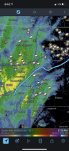
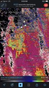
We really are just a couple ticks south with the upper low of seeing the pivot point of that deform band be right through CLT metro, and as you said the hi-res are really showing the potential for some very intense bands. This really does remind me a lot of that February 1999 system that I mentioned yesterday
 
We really are just a couple ticks south with the upper low of seeing the pivot point of that deform band be right through CLT metro, and as you said the hi-res are really showing the potential for some very intense bands. This really does remind me a lot of that February 1999 system that I mentioned yesterday
Oh that’s a really good analog I honestly hadn’t considered.
 
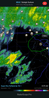
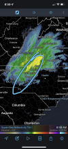
It may not look like much. But if these tiny shifts south can happen throughout the day it will put a lot more people in NC in the game for some snow


Sent from my iPhone using Tapatalk
I could see it even putting more in upstate in play, because I think the more South it can go the more Cold air gets wrapped into it.

Sent from my SM-A526U using Tapatalk
 
Oh that’s a really good analog I honestly hadn’t considered.
Yes and I remember a few hours before the period of heavy thunder snow, there was some intense thunderstorms with small hail that came through. It should also be noted with that system that no local media outlets or the NWS were forecasting accumulating snowfall for the Piedmont until literally the ground was getting white.
 
I'm liking the south trends. Us I-40 peeps need all the help we can get. I think points along and NW of 85 from Charlotte on might get a dusting if the deform band materializes. Good luck guys. The next few weeks is make it or break it especially in this Nina.
 
I’m thinking that Hwy 64 is too far south to draw a battle line. From RAH at 6:21 AM EST this morning:

“Rain will gradually change to snow from west to east across north-
central North Carolina between 5 and 8 AM Monday. The heaviest and
most prolonged snow will occur north of the Hwy 64 corridor, and
especially farther north near the VA border. Due to the recent
abnormally warm conditions and warm ground, we do not expect major
travel problems. However, its possible that an inch or so of wet
slushy snow may accumulate on grassy areas, especially north of Hwy
64 and the closer you get to the VA border. Any travel-related
problems should be confined to elevated roads and bridges, where wet
slushy snow may gather. South of Hwy 64, little if any snow will mix
with the rain. All precip will be over by mid-afternoon.”
 
Back
Top