Sleet reports near mebane now noice !
-
Hello, please take a minute to check out our awesome content, contributed by the wonderful members of our community. We hope you'll add your own thoughts and opinions by making a free account!
You are using an out of date browser. It may not display this or other websites correctly.
You should upgrade or use an alternative browser.
You should upgrade or use an alternative browser.
Wintry Jan 2-4 2022 Winter Weather Event/Obs
- Thread starter SD
- Start date
It's official Snow/Sleet coming down in Frosty's Winter Wonderland 37.5
43 degrees and things are calming down after a thunderstorm and a brief power outage near the McCullers community south of Raleigh. This has been an intense storm and a dramatic changeover from record warmth the past several days to possible winter precipitation later today.
I think you will be ok you won't have to worry as much about the southern end of the deformation band drying up like we willYeah I posted in whamby because I figured I was wishing but it does look better further south, radar really is encouraging and this is a powerhouse system so who knows
Staring to get some sleet mixing in at times!
She's a beaut Clark 

Nomanslandva
Member
I guess about an inch here. 
Edit It was more like 2. Now right at 2.5.
Edit It was more like 2. Now right at 2.5.
Last edited:
D
Deleted member 1449
Guest
All snow here now with a coating on the grass and roof tops.
Update, almost all sleet. That was fast.Staring to get some sleet mixing in at times!
LukeBarrette
im north of 90% of people on here so yeah
Meteorology Student
Member
2024 Supporter
2017-2023 Supporter
35 degrees now in Roanoke. Snow not as heavy now. Looking like we will probably be at 3 inches before it’s done.
norcarolinian
Member
All snow. Wind roaring. Couple more cedars bit the dust. 33.1 degrees

Last edited:
Eating breakfast at a small cafe in Spotsylvania Courthouse.
You are about to get an overperformer, congrats!All snow here now with a coating on the grass and roof tops.
Power just went out wait back on but probably not for long
SimeonNC
Member
Can't wait for that band in the foothills to get closer lol.
Now I wait for precip to fill back in. Dry other than light sprinkles
I'm really hoping it's not for a few hours.
I'm really hoping it's not for a few hours.
LukeBarrette
im north of 90% of people on here so yeah
Meteorology Student
Member
2024 Supporter
2017-2023 Supporter
Holy cow
Yeah I do wonder if the backdoor front slipping through saved us this morning and elevated the storms just enough so we didn't get the insane wind we could have with fully sfc based stormsWas a bit of nothing, must have been in a lull somehow. Back to dead calm and misting rain. Max 15mph gust and Rudolph didn’t budge.
Have a feeling once we get better precip back over us .. this sleet/snow/rain line will continue moving south great reports right now 
jovialweather
Member
Saw a few trees blocking some neighborhood streets and one car in a ditch (not sure how on a simple little 15 to 20 mph neighborhood road). Those gusts that came through earlier did some work. This is near 540/ Six Forks area.
GarnerNC
Member
Man this wind is something else. I've heard more limbs cracking and falling this morning than some of the larger storms we've gotten recently.
Cars slushing up, getting that betaifull white look to em. Another winter in the books, seeing a trace in NC and avoiding the shutout, Mission accomplished.
packfan98
Moderator
Dry slot here for a little while it looks like. Should be snow when it picks back up.
Yea, No doubt the worst winds weve had heer that I can remember.Man this wind is something else. I've heard more limbs cracking and falling this morning than some of the larger storms we've gotten recently.
iGRXY
Member
Light snow/sleet/rain mix here as the cold air is really breaking out from the mountains along highway 14 and interstate 26 moving south. Was at 45 degrees about an hour ago and I am down to 37 now. If we could've just slowed the precip down by a few hours I think this would've been a surprising little event even here in the upstate for some.
GarnerNC
Member
Temp has dropped 15 degrees since 530.
BruhLight snow/sleet/rain mix here as the cold air is really breaking out from the mountains along highway 14 and interstate 26 moving south. Was at 45 degrees about an hour ago and I am down to 37 now. If we could've just slowed the precip down by a few hours I think this would've been a surprising little event even here in the upstate for some.
.gif")
.gif")
.gif")
ML lows on the last mesoanalysis near CLT should move just south of RDU basically over @Rain Cold and I
Fgen at h7/85 should trail it bringing precip back and change to snow/sleet


iGRXY
Member
Friend in Landrum also reporting some light sleet mixed in with the very light rain. Another friend in near the 26/85 interchange says all rain still there. But the moisture is quickly rolling out of here so at least I got my 15 minutes of technically something frozen falling from the sky.
Sam Sparks
Member
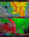
Ended up with about 2" IMBY. Here is the power outage map this morning for my area.
Man the Hrrhrhrrrrr is cutting it clooooose.View attachment 101510
View attachment 101512
View attachment 101513
ML lows on the last mesoanalysis near CLT should move just south of RDU basically over @Rain Cold and I
Fgen at h7/85 should trail it bringing precip back and change to snow/sleet
View attachment 101515View attachment 101514
Temp down about 5 degrees in the last hour though.
NBAcentel
Member
39F
GarnerNC
Member
Sun and blue skies now, what a wild morning.
Coming down Good now. Good flake size, rates and monster wind wept. This is what you want to see here , happening on radar over PTI. Hope that helps those tracking.
Shaggy
Member
We just now went from 61 to 52 in the span of one observation period at PGV.........that's 9 degrees in 15 minutes.Temp has dropped 15 degrees since 530.
And I still won't see any snow today
No kidding. Convection on the HRRR...tspl tssn anyone?Man the Hrrhrhrrrrr is cutting it clooooose.
Temp down about 5 degrees in the last hour though.

Power outages starting to become a problem for a lot of places. Duke is up to about 150K in NC alone.
I got woken up by a very loud Flood Warning notification in the middle of the night!
SWVAwxfan
Member
Per James Spann. It actually snowed early this morning in Okaloosa County Florida.