Yessss that constant roar very tropical storm like, crazy!It is really creepy out here right now. Wind is howling, there is lightning, the temps are in the 40s, and a line of severe storms is approaching. The wind is constant and you can hear it just overhead, like a tropical system. The trees are creaking in the higher gusts.
-
Hello, please take a minute to check out our awesome content, contributed by the wonderful members of our community. We hope you'll add your own thoughts and opinions by making a free account!
You are using an out of date browser. It may not display this or other websites correctly.
You should upgrade or use an alternative browser.
You should upgrade or use an alternative browser.
Wintry Jan 2-4 2022 Winter Weather Event/Obs
- Thread starter SD
- Start date
GarnerNC
Member
Just got a nice crack of thunder, feels/sounds like a summertime storm out there.
LukeBarrette
im north of 90% of people on here so yeah
Meteorology Student
Member
2024 Supporter
2017-2023 Supporter
D
Deleted member 1449
Guest
50/50 rain/sleet now
WEATHERBOYROY
Member
I live just north of Pinson Al. we had just over 2 inches on the cars this morning...there were still flurries when I left the house at 5 am. I would have liked to have gotten the snow we lost due to melt...We didn't go to freezing until towards the end of the heavier snow.
SimeonNC
Member
FWIW it has been initializing too warm.Hrrr doesn’t even have anything here anymore. Yikes
But ground temps!View attachment 101496
Already on roads…
I just had an inflatable Santa and a led reindeer blow down the streetYeah that line looks like it means bizness
LukeBarrette
im north of 90% of people on here so yeah
Meteorology Student
Member
2024 Supporter
2017-2023 Supporter
Yup I was doubter, but rates overcomeBut ground temps!
Snow within 10 days!!Just got a nice crack of thunder, feels/sounds like a summertime storm out there.
Yea don’t like where this is headed for us, brutalHrrr doesn’t even have anything here anymore. Yikes
SimeonNC
Member
43.5 now, light rates. Hopefully some heavier rates return.
SimeonNC
Member
Looking at the soundings on pivotal, it looks like a wet snow sounding I think. We might have a chance.Yea don’t like where this is headed for us, brutal
Snownut
Member
Yep probably this weekend. Maybe more folks will be included in it.Snow within 10 days!!
Sent from my SM-A526U using Tapatalk
This temperature drop is something. Every time a gust of wind comes up the temperature drop a degree. Down to 43
iGRXY
Member
this is what I was afraid of. Storm is moving faster than expected and cold air delayed coming over the mountains. I wouldn’t feel too good if I was anybody outside the mountains in NC/SC.
I feel good about flakes temps dropping fast and Greensboro already in the 30s that will only continue to filter down this way next couple of hours and then the back band moves through it’ll be what it’ll be I guess ??this is what I was afraid of. Storm is moving faster than expected and cold air delayed coming over the mountains. I wouldn’t feel too good if I was anybody outside the mountains in NC/SC.
I see the sun and blue sky.
LukeBarrette
im north of 90% of people on here so yeah
Meteorology Student
Member
2024 Supporter
2017-2023 Supporter
Sleet mixing in.
Thats on the list of our favorite winter storm parameters, I believe, along with waiting for cold air and hoping the deform band moves through before drying up.I see the sun and blue sky.
Tempest reported a max gust of 25, but I think it was more than that. The pole it's mounted on sways too much.
Is it bad I was happy to see that we are getting dry slotted bc caa is about to kick in for the mid levels lolThats on the list of our favorite winter storm parameters, I believe, along with waiting for cold air and hoping the deform band moves through before drying up.
Tempest reported a max gust of 25, but I think it was more than that. The pole it's mounted on sways too much.
Still holding out hope for a couple hours of flakes
Pea Ridge
Member
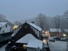
Waterloo, AL. Couldn't miss hunting in the snow in Alabama. Rare as hens teeth.

Sent from my Pixel 4 XL using Tapatalk

Sent from my Pixel 4 XL using Tapatalk
packfan98
Moderator
Got some sleet here. Earlier than projected. Let’s see if we can get a snow burst later to cap off a wild event.
Sva_SN
Member
33 degrees and predominantly sleet 20 miles North of Roxboro. Hoping to see a changeover soon. Edit.. snow mixing in now
Last edited:
All snow/slush up by airport now. GSO
RCS Closed for the Day
RCS Closed for the Day
For those of us just to the S and E of Raleigh we are riding a fine line late this morning between nothing, just rain, heavy snow burst. The gsp and cae radars are at least encouraging
Hardly anything left when I woke up this morning. It’s crazy because I’m seeing pictures in pinson and trussville with an easy 1.5-2 inches in the grassy areas and surfaces. Huntsville looks amazing.
Outside of the mountains it really seems like the system is busting and moving wayyyy fast. Hope we get a nice one to track here soon. The quick hitters are fun to watch fall, but I definitely was disappointed to have nothing to speak of after getting up.
Outside of the mountains it really seems like the system is busting and moving wayyyy fast. Hope we get a nice one to track here soon. The quick hitters are fun to watch fall, but I definitely was disappointed to have nothing to speak of after getting up.
42 here. Down 3 degrees in the last 30 mins
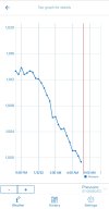
Since we can't get winter winter wx atleast we can enjoy our semi tropical storm. Almost lost power with that last line and the pressure drop was significant so far.For those of us just to the S and E of Raleigh we are riding a fine line late this morning between nothing, just rain, heavy snow burst. The gsp and cae radars are at least encouraging
GarnerNC
Member
Looks like things are claaring for the moment here.
The dry slot is beginning to take shape.Looks like things are claaring for the moment here.
Yeah I posted in whamby because I figured I was wishing but it does look better further south, radar really is encouraging and this is a powerhouse system so who knowsFor those of us just to the S and E of Raleigh we are riding a fine line late this morning between nothing, just rain, heavy snow burst. The gsp and cae radars are at least encouraging
SimeonNC
Member
41.9 Here, finally back under some decent precip rates.
Sure was bottomed out at 997 here before the stormsSince we can't get winter winter we atleast we can enjoy our semi tropical storm. Almost lost power with that last line and the pressure drop was significant so far.
View attachment 101499


