HSVweather
Member
Dude calm downalways mr negative smh

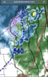
View attachment 101321
From Spann
tell him that, I was responding to what he saidDude calm down


always mr negative smh

always mr negative smh
He wasn’t being negative. He was stating it would a thing to see.How's is that negative ?
Sent from my iPhone using Tapatalk
The dry slot?This wizard hat looking thing is a neat looking feature.
View attachment 101326
Sent from my iPhone using Tapatalk
We live in the south, been there done that.everything that shows more snow, better cases, you doubt it

I see a tornado and RFD.This wizard hat looking thing is a neat looking feature.
View attachment 101326
Sent from my iPhone using Tapatalk
Sister is in Nashville, and as of 9 pm still no accumulation.Nashville might be the winner . They are close to going all snow huge moisture fetch headed their way
Sent from my iPhone using Tapatalk

Ok, my bad. It's all good. Sorry Charlie. Let is snow!He wasn’t being negative. He was stating it would a thing to see.


Mixed rain and snow report near Athens as well, feel like it’s early for that thereA second sleet report near Dalton GA verifying the first. Interesting
I’m not sure about that report, but seeing two in close proximity confirms that to me. It is definitely early. Mid-high 40s in that area right nowMixed rain and snow report near Athens as well, feel like it’s early for that there
If only we had 10:1 ratios. I'm worried that it will only be like 5:1.
weenie map
right on scheduleMixed rain and snow report near Athens as well, feel like it’s early for that there

Its gonna be roof demolishing fatties though.If only we had 10:1 ratios. I'm worried that it will only be like 5:1.