Storm5
Member
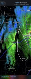
Dry slot city

Sent from my iPhone using Tapatalk

Sent from my iPhone using Tapatalk

I get lollipop’d here. HuggingView attachment 101342
This is the life I live.


I agree @Storm5. I just don’t see it happening unfortunately.Dry slot city
Sent from my iPhone using Tapatalk

gonna rip if you can change to SN with this bandDry slot city
Sent from my iPhone using Tapatalk


I would hate to see a 10-15in snow coming for the se because it would be mass hysteria almost everywhere lol???
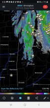
Roofs are white and starting to stick in grassIf you’re in Huntsville I would be excited banding developing over you solid heavy snow .. already at freezing so that’s great or accumulations along with it being at night and more development with the banding out west .. buckle up
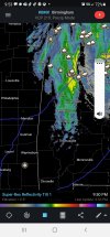
That is some rapid Storm and moisture uptick in a short windowYou can see the rapid intensification of that wraparound band from the ull tilt you will see more moisture buildup along with these leading edges getting heavier this was all bands of green 30 minutes ago
Went into this just hoping to watch my son see snow falling for first time, seems like we're on track but we shall see!I have yet to be worried ??
You are on fire! ?Is winter still cancelled? ?
well, whisper sweet nothings in her earDry slot city
Sent from my iPhone using Tapatalk
I’ve had several people here say that it was sleeting. I’m from Dalton. I’m not saying it makes sense….That's incorrect. Just drive up from there and temp was 51° in car and plain rain.
Sent from my moto z4 using Tapatalk
Great pics...very happy for you folks in Bama..love me some Lake Guntersville!