Ron Burgundy
Member
We really need that SW trend to continue. I think you’re in good shape up your way tho. ITP probably a few flakes as usual but still clinging to hope. The cutoff gradient is brutal.12z NAM.

We really need that SW trend to continue. I think you’re in good shape up your way tho. ITP probably a few flakes as usual but still clinging to hope. The cutoff gradient is brutal.12z NAM.
You can take that to whamby or your personal thread.Let me tell y’all a couple things I learned about the HRRR and the NAMS the last few days.......... they suck!
This would result a slightly less amped system/less -tilt, 13z hrrr shows thatStarting to notice the HRRR slighty slow/strengthen the northern stream energy/confluence around the Great Lakes
This could definitely help put more of NC in the game. Also, looking at these thunderstorms that the HRRR is showing in the 3-5am timeframe for CLT, I can’t help but wonder if those could aid in cooling the column more quickly before that deform band rolls throughStarting to notice the HRRR slighty slow/strengthen the northern stream energy/confluence around the Great Lakes


And/or some impressive hail/graupel p-types.This could definitely help put more of NC in the game. Also, looking at these thunderstorms that the HRRR is showing in the 3-5am timeframe for CLT, I can’t help but wonder if those could aid in cooling the column more quickly before that deform band rolls through
Possibly and if not there could legitimately be some hail with these thunderstorms, steep mid level lapse rates (7C) and cool mid level temps could do the trickThis could definitely help put more of NC in the game. Also, looking at these thunderstorms that the HRRR is showing in the 3-5am timeframe for CLT, I can’t help but wonder if those could aid in cooling the column more quickly before that deform band rolls through
You already know the answer...lol Roxboro guna get theirsSo should I go to Virginia tomorrow or not ? Roxboro? It’s only 50 minutes away.


Always crazy they don’t include Coosa and Tallapoosa counties. Cold air always funnels into the northern half of these counties.
Now they are saying up to 2 inches. Let the games begin !!

Dc going from 9 inches to 1.4 inches ?Yeah that was a decent shift south this late in the game, very least maybe north trend is ova
View attachment 101068
Temps also down to around 33 before this deform band moves over areas which should be better at getting a chance at something slushy .. trees will love itCAMs look like how they did at 00z View attachment 101074View attachment 101075View attachment 101076
Not DC lol they have some pretty erroneous bad luck just as much as us3k looks similar to 12k. That 50-100 mile shift south put the I-85 corridor back in play and put DC on the northern fringe. We know who usually wins that battle though.

Very interesting they didn’t include Randolph as well.
Then you read this from FFC and wonder what planet they are on

Great!! Keeping it simplified, I love it. And if I may, since we are going to keep all things related to this event, including all obs, in one thread it is very important to keep banter out, please. It's happening! Good luck everyone and Godspeed!Fyi unless someone can convince me otherwise probably going to not have an obs thread and just keep everything rolling in here
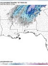
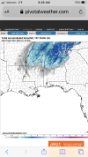
Looks like the actual precip shield versus what was model on most models is far more expansive/intense and west.

IDK seems reasonable to me?Then you read this from FFC and wonder what planet they are on
expect a transition to
light rain/snow showers and to a period of all snow across portions
of north Georgia between 2-8am tomorrow morning. Portions of the
north Atlanta metropolitan area could see a dusting of snow -
generally less than 0.25 inch with the higher elevations could see
up to 2 inches. As the upper low pulls away from the area Monday,
skies will clear with good sunshine expected across much of the area
by mid to late morning, so any snow should melt quickly.
Ahhh... I'll say this personal think this is slight undersale because they know they can ramp up verbiage by noon if necessary. Looking at radar and models seems to point that areas from Carrollton up thru Cobb and then then Ball ground definitely in a good spot for accumulating snowA planet smarter then us.
Yea but they also look at past storms with the same or similar set up. I know Kirk Mellish does this as well. I really hope they are off because I’m a huge snow weenie but I just don’t see it.Ahhh... I'll say this personal think this is slight undersale because they know they can ramp up verbiage by noon if necessary. Looking at radar and models seems to point that areas from Carrollton up thru Cobb and then then Ball ground definitely in a good spot for accumulating snow
TWC still had DC in the 5-8in. Guessing they believe in a N trend today,Best news I’ve seen in a year. And it’s not even close ??
Roll tide on that. It looks like the biggest event for my in laws in Marion County, potentially, in a while.
Not. Gonna. HappenT
TWC still had DC in the 5-8in. Guessing they believe in a N trend today,