Can’t say these trends aren’t discouraging but at the end of the day the pattern as a whole is looking good later on for us to score something better than a paste bomb on warm ground so at least that’s something to look forward to
-
Hello, please take a minute to check out our awesome content, contributed by the wonderful members of our community. We hope you'll add your own thoughts and opinions by making a free account!
You are using an out of date browser. It may not display this or other websites correctly.
You should upgrade or use an alternative browser.
You should upgrade or use an alternative browser.
Wintry Jan 2-4 2022 Winter Weather Event/Obs
- Thread starter SD
- Start date
Gfs has 9 inches Gboro lol.
21 Fancy Gap.
And 1/2-1 here!
 dry/slot baby!
 Sent from my iPhone using Tapatalk
Ward Cleaver
Member
It was 11” the previous run. Haha! I’ll be floored if we get a slushy 1”.Gfs has 9 inches Gboro lol.
21 Fancy Gap.
ForsythSnow
Moderator
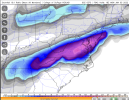
Those trends for us in AL and GA keep getting better. I guess as it gets more amped the wrap around becomes more intense and the cold air can really get into the heavier precip and deform band.View attachment 100953
Last three run trends.
Early logistics, NW of Richmond I 95/64 or Delmarva SR 90 north of Salisbury. Still about 12-18hrs to work it out.
I am not used to having good trends. LolThose trends for us in AL and GA keep getting better. I guess as it gets more amped the wrap around becomes more intense and the cold air can really get into the heavier precip and deform band.
NBAcentel
Member
While the rap looks a tad more amped, it actually looks like it’s digging more south this run in texas , let’s see what it does
SWVAwxfan
Member
24+ in my area. That's insane.20 inches over me on pivotal??? GFS off its rockers
Snownut
Member
And I would think the more amped it is the More Cold air it would pull in, which only helps as it moves east.While the rap looks a tad more amped, it actually looks like it’s digging more south this run in texas , let’s see what it does
Sent from my SM-A526U using Tapatalk
Ron Burgundy
Member
Looking a lot better up your way for sure. Still holding a little hope for the intown crowd but I think we’re going to be lucky to see a few flakes.Those trends for us in AL and GA keep getting better. I guess as it gets more amped the wrap around becomes more intense and the cold air can really get into the heavier precip and deform band.
NBAcentel
Member
ULL is even stronger this run 


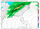
Trending towards another DC mauler. This is like 2009-2010 winter all over again.View attachment 100953
Last three run trends.
Huge increase on GFS ensembles. 
SnowNiner
Member
Still trying to figure out the totals for the balsam mountain ridge tops. Clown maps showing warning criteria but it looks really quick hitting by the time the Temps crash and no nw flow to speak of on Monday. Not sure it can get out of advisory criteria, but ill take whatever at this point.. Get the feeling this is a pattern change storm that we just need to get through for better things to come the next few weeks.
SWVAwxfan
Member
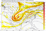
Some of those members show amounts that boggle the mind.dang, bombs away on the 0z GEFS. 6+ CHA northeastward
View attachment 100971
'
View attachment 100968
NBAcentel
Member
that H5 track this run is ugly but still 

Snownut
Member
I'm just wondering if the Models are having trouble with this Due to all the severe weather to the West. We may see them really pick up on things tomorrow after those storms move through.
Sent from my SM-A526U using Tapatalk
Sent from my SM-A526U using Tapatalk
SimeonNC
Member
The RAP has the backside/deformation band last quite a while into the day on Monday and the winds are pretty high too. Going from a high in the 70s to wind and snow falling in Monday morning/early afternoon.
RAP is legacy material, Euro to come in more amped. Again. Hats off to the convective models, they did a solid job beyond 72hrs while the globals did waver in day 4-5.
SimeonNC
Member
Windchills are in the mid-20s during this, damn lol.
NBAcentel
Member
Rap looks good aloft but since it’s trending NW BL temps start becoming a issue 
ForsythSnow
Moderator
Greatest run for N GA of the RAP so far
believe a third of what models are showing then half of that and we will be fine with a slushy mess. We can always dream
This is unreal. The NAM sniffed this out for our area from the beginning and now the gfs and rap have joined the party with 2-3+ inches of snow falling in the Birmingham area. Notice I said “falling”. But we 100% will have some accumulation in the grass and elevated surfaces if these verify.
Don’t even want to get into what could happen if this thing trends stronger back to our west. I’m getting 3/1/09 vibes.
Don’t even want to get into what could happen if this thing trends stronger back to our west. I’m getting 3/1/09 vibes.
Storm5
Member
High res models trending much better for areas to the west . Every single minute this slows down helps areas west of the mountains.
Sent from my iPhone using Tapatalk
Sent from my iPhone using Tapatalk
wow what a band. 
Yea it’s showing like 4-6 inches. If you cut them totals in half because of warm ground. You are still getting 2-4 inches.High res models trending much better for areas to the west . Every single minute this slows down helps areas west of the mountains.
Sent from my iPhone using Tapatalk
Storm5
Member
Someone in eastern tenn or the NC mountains is gonna jackpot under the band as everything slows and pivots
Sent from my iPhone using Tapatalk
Sent from my iPhone using Tapatalk
Stephenb888
Member
Tomorrow we are going to really see this thing slow down to the point where this becomes an event to remember for all of us.
SimeonNC
Member
Haven't BL temps been the issue the whole time?Rap looks good aloft but since it’s trending NW BL temps start becoming a issue View attachment 100977
NBAcentel
Member
Well we was getting runs with temps around 33-35 now it’s more 35-38 given how amped it isHaven't BL temps been the issue the whole time?
JLL1973
Member
Memphis just issued a special weather statement for the midsouth stating their could be some minor accumulations on grassy surfaces
Snowflowxxl
Member
I am officially intrigued for here. I think I might see some flakes
Snownut
Member
I don't see that happening but I think it trends better for everyone. I think it slows down enough to get more Cold air wrapped into it.Tomorrow we are going to really see this thing slow down to the point where this becomes an event to remember for all of us.
Sent from my SM-A526U using Tapatalk
Here our CMC. 
JHS
Member
Upstate SC is out of this one and it could be a long time before the Carolinas get another chance.Tomorrow we are going to really see this thing slow down to the point where this becomes an event to remember for all of us.
Snownut
Member
Seriously? Have you even looked at the long range and at the Pattern change that's happening after this storm? There's several shots between now and mid Jan. And that includes the upstateUpstate SC is out of this one and it could be a long time before the Carolinas get another chance.
Sent from my SM-A526U using Tapatalk
Snowflowxxl
Member
Huntsville definitely looks like the place to be