Round #2
Looks real good. So show me that fizzle out into nothing boys.
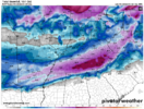
On the next frame it’s snow from I-77 east in NC and the most eastern portions of the SC upstate. Probably not a lot but it’s under 528 line so it would probably be some higher ratio stuff. A second area of precip holds back over the southern half of Alabama and Georgia with a stripe of snow on its north… it drops down and looks like it evolves into the coastal that fires up 36 hours later bring snow to the coastal sectionsLooks real good. So show me that fizzle out into nothing boys.


From the canonical -NAO perspective, this one certainly fits the bill. Still doesn't mean we can't score twice though!Congrats to those in NW Piedmont, Apps and western SE sections will be in order for the first system. This one around the 21st will be ours on the east side. Right where we want it 8-9 days out
View attachment 141672
believe in the table setter theory.Are any of the upcoming systems going to be a happy ending for areas in central GA (just north of I-20 line)?
Are any of the upcoming systems going to be a happy ending for areas in central GA (just north of I-20 line)?
My area does much better with solid cold levels already in place versus timing from cold delivery from the northwest. I can almost guarantee the cold will not make it far enough southeast to produce snow, sleet or freezing rain. It will just be plain ole rain in Atlanta south. Alpharetta, White and Gainesville, GA and points northwest might be cold enough. Out west near Buchanan, Dallas to Kennesaw will have a shot, too. They have some elevation to help them. Everyone else in GA can start looking to the 20th for another possible chance (though the 0z Euro said it will be a cutter).believe in the table setter theory.

I'm autistic and have trouble with idioms sometimes, what does table setter theory mean?believe in the table setter theory.
The first one misses but sets the tone. The second one hits & brings the glory.I'm autistic and have trouble with idioms sometimes, what does table setter theory mean?


What even is going on at this pointYall like those 1051 HP's. Love to see this sitting over NY/PA state line and a Miller A cruising along GOM shoreline. Been a while! Be some good static electricity in the house if this panned out


Low level cold, but extended pacific jet is flushing out cold in the upper Low levels/mid levelsWhat even is going on at this point
Oh no. Our snowpack!What even is going on at this point
Look how the GEFS is trying to play catch up with the lowering of heights along the west coast. That should hopefully let another piece of energy come down the pike to finish the pattern and give yall a storm there.
Do you see any chances at all for upstate sc coming up or are we gonna have to wait for Feb?Look how the GEFS is trying to play catch up with the lowering of heights along the west coast. That should hopefully let another piece of energy come down the pike to finish the pattern and give yall a storm there.
This is not there yearDo you see any chances at all for upstate sc coming up or are we gonna have to wait for Feb?
So it sounds like two more chances for NC and then the pacific jet flushes the cold away and then it rebuilds in early February for one last hoo-rah?Look how the GEFS is trying to play catch up with the lowering of heights along the west coast. That should hopefully let another piece of energy come down the pike to finish the pattern and give yall a storm there.
I think there is still a chance for upstate SC from both systems next week, right? By upstate, I'm thinking Spartanburg north to the border.Do you see any chances at all for upstate sc coming up or are we gonna have to wait for Feb?
Sounding like it. Webb mentioned the other day there would be a short warming 23rd/24th timeframe? before pattern cold reloads I believe near end of monthSo it sounds like two more chances for NC and then the pacific jet flushes the cold away and then it rebuilds in early February for one last hoo-rah?
There's no their there.This is not there year
")
That is really strange looking....I don't think I've ever seen 850s sub freezing in the gulf of Mexico and 50 degrees at my house in Jefferson county? also the dewpoint seems crazy low on my sounding?What even is going on at this point

ThanksThere's no their there.

This is the reverse ju-ju I’ve been waiting for. ?? CAD areas will be tracking by Sunday night. Bank on itThis is not there year
Nothing past 200 hours matters. It will be completely different tomorrow.What even is going on at this point