Current dreams of future past.It’s not made up. That really was a good stretch.
My area had 13" at 16 degrees during one of the many storms during that winter.
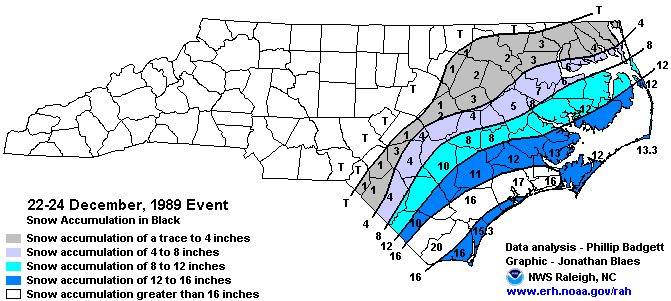
87 and 88 is what I tell my kids about every winter. Been chasing ever since
")
Current dreams of future past.It’s not made up. That really was a good stretch.
Here in Pittsboro NC we will forever love 87-88. Wish another one like that would happen. Ice that made the county stand still (no one on the roads) followed by a foot of snow.Current dreams of future past.
My area had 13" at 16 degrees during one of the many storms during that winter.
87 and 88 is what I tell my kids about every winter. Been chasing ever since
This board would go crazy if we got a repeat of that winter. Some of the southeast scored big in APRIL that year, even outside of the mountains, and if that low had tracked farther southeast even more areas would have been hit.Winter reminding me of 87...and we know how good the back half of 87 was.
87 mid-Jan...
View attachment 139439View attachment 139440


I’ll never forget the storm that January that the NWS and local mets got completely wrong for CLT metro. The 6pm news the night before everyone was predicting CLT metro to get mainly rain with snow mixed in at times. The only exception was WBTV who at the time Accuweather did their forecasts and was forecasting CLT to get 4-7”. Joe Bastardi was on WBT radio giving that forecast even with no watches or advisories for the area. By the 11pm newscast, the NWS office and local mets were having to scramble because it was very clear based on upstream obs their forecasts were going to bust badly.This board would go crazy if we got a repeat of that winter. Some of the southeast scored big in APRIL that year, even outside of the mountains, and if that low had tracked farther southeast even more areas would have been hit.
Some of the higher peaks on the Tennessee line should be doing really well the next couple weeks. My personal preference is Carvers Gap, which is a little over 5,000 feet elevation and can be reached by highway 261. Once you’re there you can take short hikes to some beautiful vistas that are closer to 6,000 feet elevation. As far as places to stay nearby, Newland, Bakersville, and Spruce Pine have plenty of options.gonna head to nc mountains soon,best place to go for snow thats not ski area??
thanksSome of the higher peaks on the Tennessee line should be doing really well the next couple weeks. My personal preference is Carvers Gap, which is a little over 5,000 feet elevation and can be reached by highway 261. Once you’re there you can take short hikes to some beautiful vistas that are closer to 6,000 feet elevation. As far as places to stay nearby, Newland, Bakersville, and Spruce Pine have plenty of options.

I looked at the kuchera maps and I didnt see anything for those areas. It could mean something is falling but not sticking.
I’ll never forget the storm that January that the NWS and local mets got completely wrong for CLT metro. The 6pm news the night before everyone was predicting CLT metro to get mainly rain with snow mixed in at times. The only exception was WBTV who at the time Accuweather did their forecasts and was forecasting CLT to get 4-7”. Joe Bastardi was on WBT radio giving that forecast even with no watches or advisories for the area. By the 11pm newscast, the NWS office and local mets were having to scramble because it was very clear based on upstream obs their forecasts were going to bust badly.


Probably almost anywhere over 3500'.gonna head to nc mountains soon,best place to go for snow thats not ski area??
I don't even see how that's physically realistic.Probably irresponsible to post as the timeframe and the likelihood of seeing it but this would seem too cold for what we want. Probably suppress any moistureView attachment 139462
He meant to say that’s what dreams are made of, not up, so I was picking at him.It’s not made up. That really was a good stretch.
It’s from 3 days ago also which is equivalent to 5 weeks ago in weather model time.I don't even see how that's physically realistic.
I understand, I was just looking back over the past weeks model runs and saw it, thought it was interesting. Like I said in op, I know its slim to none to happen.It’s from 3 days ago also which is equivalent to 5 weeks ago in weather model time.
Always at the end unfortunately…. Still think most January will be toast . February looks lot better with mjo movementi dont really hate where we are going with the models..cold looks to be on the move toward end of euro
Yep. Pacific forcing will come back in late jan/early FebAlways at the end unfortunately…. Still think most January will be toast . February looks lot better with mjo movement
What's it got at 500mb for Noam?
Noam? Acronym (if it is one) is new to me I guess lolWhat's it got at 500mb for Noam?
Lol I was being lazy. North AmericaNoam? Acronym (if it is one) is new to me I guess lol


Now to get some energy to round the base of this trough.would b game on for many
Kind of crazy that's really a positive trend everywhere you'd want to see it
Get the -NAO to go bonkers and tuck more of this blue up under the block post cutter, and we'd have a shot with a follow-up wave. EPS Snow map here has some light action per this scenario.Now to get some energy to round the base of this trough.would b game on for many


So what's so bad about the 2nd and 3rd week in Jan? Serious question because I haven't looked in days at anything because I figured we could turn the lights out until Jan 20th at least because the trough was going out west for 2 weeks according to most?
Feb is severe season now.Always at the end unfortunately…. Still think most January will be toast . February looks lot better with mjo movement
Great post!So pretty much here’s the deal and what we want. We want the 1/4 system to become a blizzard as far west as we can get it (New England blizzard would work). This gives us confluence for 1/7 system (probably a mid-atlantic storm only but we will see). Then want the 1/7 to trend stronger and slower so that it can provide confluence for the cutter system that could produce some onset CAD mixed precip. Let the cutter move through give us the cold air and then hope for a follow up wave.
Pretty amazing to see how important 50/50 lows areGreat post!


.png")


.png")