Shaggy
Member
3k nam fires that 2nd line of storms that really boosts our totals on the model. The HRRR and FV3 hi res do not have that line of storms.hrrr was meh on rain View attachment 130773
3k nam fires that 2nd line of storms that really boosts our totals on the model. The HRRR and FV3 hi res do not have that line of storms.hrrr was meh on rain View attachment 130773


id take feb 2021 in a minuteLol Feb 2021 vibes View attachment 130794View attachment 130795
Maybe it can do the opposite it did then and trends towards unloading it on us instead to our West. LolLol Feb 2021 vibes View attachment 130794View attachment 130795
2 degrees above normal at 850. Let me go get my Speedo! In all seriousness though get ready for some cold rain CAD events they coming!Lol Feb 2021 vibes View attachment 130794View attachment 130795

View attachment 130808
Another Mtn Snow day

It is but you gotta remember for those of us in the western and central Carolinas, we really didn’t get that warm during that period. Lots of CAD. There is a lot of similarities over the next couple weeks to February 1994 that produced that huge ice/sleet storm for the western SE and western/central Carolinas. The SER is flexing, but there is definitely signs of a lot of CAD, and we all know how that ends 95% of the timeLol Feb 2021 vibes View attachment 130794View attachment 130795


Now all it’s gotta do is bleed over ?Flashbacks intensifies View attachment 130813
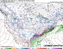
another February 2021. you have to be kidding me.Parts of the SE getting an incoming soon

Now all it’s gotta do is bleed over ?
 BRISK
BRISK

This would be best case scenario for lots of people on the board also worst case at the same time for the huge icing folks
It's really not out of the question with so much cold air just to our north. Eventually sagging south and an overrunning event very plausible and certainly not unheard of


 run by the GFS