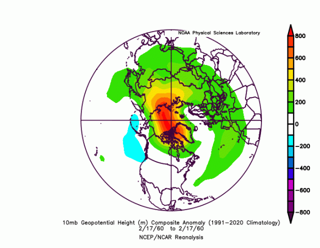
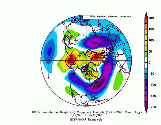
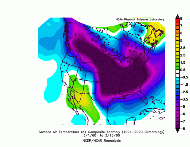
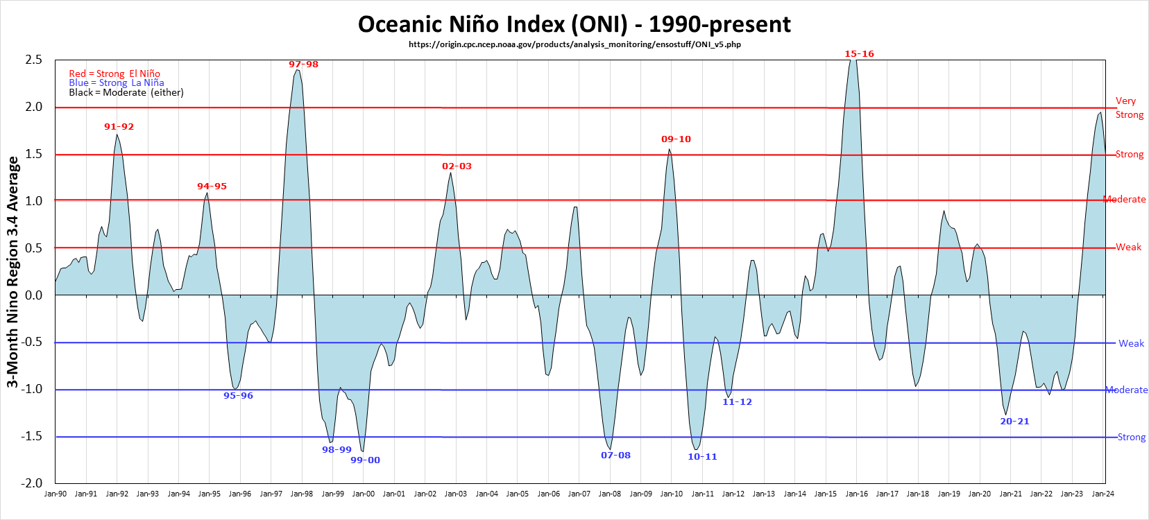
• Hello, please take a minute to check out our awesome content, contributed by the wonderful members of our community. We hope you'll add your own thoughts and opinions by making a free account!

Pattern Jammin January 2023

Wait I though El ninos are better for us than Nina's correct? We just want weak Ninos then?
Yes… weaker El Niño are preferred as moderate to strong ones tend to see the Pacific jet amp up and flood the continent with mild air
 
I had originally thought so as well but it was not in the EF-6 for December.
Wow… that’s surprising. Basically every reporting station in CLT metro recorded at least some sleet or snow that day (sleet counts as snowfall in official records). I know I had over 8 hours of sleet falling that day
 
Wait I though El ninos are better for us than Nina's correct? We just want weak Ninos then?

Yeah, except the last time we had one, the Indian Ocean dipole or something made it act like a Nina. Seriously, I really don't know what to look for anymore. The atmosphere just always wants to make the east coast warmer it seems. The pacific seems to be in a phase where the convection in the maritimes messes us up more than not.
 
The past week has reminded me once again, why I hate mod-strong El ninos and pray next years is below the moderate threshold.
I don’t share this sentiment ha. Been some good mod-strong ones over the years (09-10, 02-03, 86-87, 87-88, 65-66, 57-58). It’s the Super Ninos that are the most problematic (15-16, 97-98), though strong-super ninos 82-83 & 72-73 were wintry. Climate change may be playing a role though as the weak El Niños haven’t been cold really since the 70’s…the last good one was 79-80 (AVL-GSO did have the big snow in Dec ‘18…Weak Nino)

It’s a trade off. Nino gives you the best chance at southern stream waves and gulf lows, with risks for mild west to east Pac flow at times. Nina gives you some cold outbreaks with risks for -PNA periods…but also, -AO/-NAO have been more common in Niña compared to Nino over the last 30 years

Regarding next winter, the general sentiment is that we move toward Nino, but it doesn’t look like to me that we are going boldly in that direction
 
Last edited:
A mild February doesn't necessarily mean below average winter weather. Sometimes SER works in our favor, especially for ice. January is going to come out way above normal on temps in most of our locations, but we could still score a blockbuster storm the last week of the month.

It's fun to discuss and follow pattern recognition, but ultimately it doesn't correlate all that much with wintry weather in the Southeast, imo. I've seen lots of great patterns produce nothing, and lots of great wintry events in the midst of gross patterns. Overall, It's much more useful when discussing temperature anomalies, (but most of us aren't here to track cold/warm air events).

We could start by just getting average temperatures in our neck of the woods. Even the big trough on the eps really only pushes most locales closer to seasonal norms because there’s so much mild air in front of it
 
Yes… weaker El Niño are preferred as moderate to strong ones tend to see the Pacific jet amp up and flood the continent with mild air
Another overlooked factor is the ENSO’s orientation. West based el-ninos are best, regardless of their strength. East based La Nina’s can mimic a WB El Niño and be quite good. East based El Niño’s are usually rough.
 
Anyone have a look at these? It’s leaking my interest. Heard the control might have been good tooView attachment 129753
EPS looks better than GEFS, but don't get the sense it's enough to make it more interesting beyond rain -> backside NW flow snow for the mountains.

Small aside, but it's unfortunate that this look isn't giving more of a us an opportunity to see flakes:
eps_z500a_us_20.png
 
We could start by just getting average temperatures in our neck of the woods. Even the big trough on the eps really only pushes most locales closer to seasonal norms because there’s so much mild air in front of it
IMO, what we really need to see to get some legitimate chances for those of us east of the mountains is some better snowpack in the northeast. It’s absolutely putrid right now especially considering we’re going into mid-January. Hopefully they to cash in later this week, so that we have a better chance at scoring on some CAD opportunities.
 
CMC looking like it’s jogging to what some of the EPS was starting to support .. don’t write this one off completely yet for NC folks
I want to think that as well but the jogs will need to continue on future runs. Take a few jumps actually to get in range of mby
 
Back
Top