- Joined
- Jan 23, 2021
- Messages
- 4,602
- Reaction score
- 15,197
- Location
- Lebanon Township, Durham County NC
They got 23.5" more than me. Lucky bastards.We got ourselves a 2 footer. What an event View attachment 130212
Dead on for my area..good job EW!Meant to post this a while back. Here's the minimum temperature map for SC during this past Christmas's cold wave.
Got to 20°F even down to Hilton Head.
View attachment 130206
Skip warm phases? View attachment 130214


Pretty close. Mt Sassafras was down to -6.Dead on for my area..good job EW!
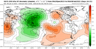
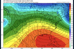
SW desert blizzard...bank on it!The GEPS finally falls in line behind what the GEFS has been showing for days, with a nice SW US cut off upper low next week
View attachment 130217
|
|
|
|
|
|
|
|
Yeah and you can already see it with the lower heights consistently showing up over the North Atlantic and SE CanadaI’m going to laugh when we trend right into a western Carolina ice storm cad special. One hood thing comes from SER, CAD. And you can bet your bottom dollar that’s where these “torches” are going to go
We've seen it over and over. The funny thing is some on here that really knows what they're talking about knows it too Yet they continue to lead one to believe Winter is over. If I was a betting man I'd bet all I have winter is a long way from over.I’m going to laugh when we trend right into a western Carolina ice storm cad special. One hood thing comes from SER, CAD. And you can bet your bottom dollar that’s where these “torches” are going to go
I will say the big difference going forward is the lower heights showing over SE Canada and the North Atlantic on the models. That was not there in 2011-12. This along with colder air moving into and building up in Canada opens the door for CAD opportunitiesWell lots of depressing outlooks right now going forward. I decided to look back at 2011-12 for some comparison. Obviously that season did not have anything comparable to the Dec cold front this year, and probably not the NWFS event from last night, but for the SE as a whole this season has been pretty absent of winter, much like that year. Here are some numbers for GSP
Dec 2011
1 2 3 4 5 6 7 8 9 10 11 12 13 14 15 16 17 18 19 20 21 22 23 24 25 26 27 28 29 30 31
Max Avg Min 55 42.2 29 63 45.9 32 58 47.3 38 57 48.9 39 56 54.2 53 65 59.6 54 63 57.8 40 52 41.1 32 54 43.1 33 54 44.0 36 47 39.0 32 45 40.8 37 65 51.9 40 66 54.5 44 67 57.7 48 69 59.5 54 58 49.5 38 55 42.4 32 58 45.3 32 55 51.7 43 63 57.0 52 65 62.6 61 64 55.9 47 53 45.4 37 50 43.7 39 55 42.1 33 52 42.5 39 51 41.1 32 55 40.4 27 54 46.3 36 63 47.3 42
Nothing exciting here but not the worst Dec ever.
Here is this past Dec. Really the only difference at all was the 4 day front surrounding Christmas:
1 2 3 4 5 6 7 8 9 10 11 12 13 14 15 16 17 18 19 20 21 22 23 24 25 26 27 28 29 30 31
Max Avg Min 55 42.5 32 55 44.0 30 58 53.0 49 57 46.3 38 46 42.6 37 50 46.1 43 63 56.4 50 69 60.4 53 58 52.3 48 50 48.5 46 50 48.9 47 56 49.1 46 48 42.9 37 42 40.8 40 48 41.3 37 52 41.6 33 49 40.8 31 49 37.3 27 49 37.0 25 42 38.5 34 48 40.3 36 48 40.9 36 47 30.4 13 27 17.0 7 37 25.1 14 38 27.8 15 48 35.6 28 54 36.8 24 64 47.1 30 59 50.4 33 56 53.0 51
Here was Jan 2012, again, nothing too exciting either way.
1 2 3 4 5 6 7 8 9 10 11 12 13 14 15 16 17 18 19 20 21 22 23 24 25 26 27 28 29 30 31
Max Avg Min 66 51.9 36 48 38.0 26 36 27.7 21 48 34.4 19 59 44.5 30 65 49.4 35 69 55.6 45 56 53.2 49 52 49.4 46 57 52.8 50 62 54.1 49 57 48.9 33 40 32.7 27 49 35.4 23 51 40.5 32 49 39.3 29 54 50.0 38 54 46.2 37 45 37.3 30 50 44.1 35 54 48.5 43 50 44.0 38 45 39.3 37 63 48.6 44 64 51.6 37 63 55.7 52 65 57.6 42 65 46.9 33 54 42.8 30 61 46.3 31 63 50.6 37
And here's so far this Jan
1 2 3 4 5 6 7 8 9 10 11 12 13 14
Max Avg Min 58 52.5 47 71 56.5 48 63 56.4 50 64 59.6 52 63 52.2 42 58 46.3 36 53 45.8 37 50 46.4 43 54 44.2 35 60 44.3 31 58 48.4 35 67 54.8 48 53 46.2 37 43 37.8 33
Literally, the only difference b/w the two is the Dec cold front and the accompanying trace of sleet/snow, with this Jan actually looking a tad warmer. Pretty sobering perspective so far.
11-12 was right up there with one of the worst winter patterns of all time. It did manage a couple week period of split flow in mid Feb that yielded a light snow event across parts of Northern NC, and that was itI will say the big difference going forward is the lower heights showing over SE Canada and the North Atlantic on the models. That was not there in 2011-12. This along with colder air moving into and building up in Canada opens the door for CAD opportunities
View attachment 130227
I hate it here
Perfect time for the hot tub if it's indoors and a liquor drink!It is gnarly up at Beech tonight. Howling winds. Sub zero wind chills. Brutal
The thing that I remember most about that winter besides the lack of snowfall was just how absolutely boring things were for 90% of the time. It was mild yes, but nothing absurdly warm… just basically 6-10 degrees above average everyday with no variability. Most of us were in a deep drought so we didn’t have any rain or severe weather to track. Just an absolutely boring period of weather11-12 was right up there with one of the worst winter patterns of all time. It did manage a couple week period of split flow in mid Feb that yielded a light snow event across parts of Northern NC, and that was it
Diet Coke?It’s lit up here4 runs and I’m DONE! FrigidView attachment 130232
Something like that!Diet Coke?
We had that one outbreak in early March 2012 that included a fairly strong UNWARNED tornado in Charlotte after 2am. We dodged a bullet in that the tornado was not stronger because it hit a high population area in the middle of the night. GSP really messed up that night, in fact I am not sure there was even a severe thunderstorm warning on it. They were paying a little too much attention to weaker storms in the GSP metro.The thing that I remember most about that winter besides the lack of snowfall was just how absolutely boring things were for 90% of the time. It was mild yes, but nothing absurdly warm… just basically 6-10 degrees above average everyday with no variability. Most of us were in a deep drought so we didn’t have any rain or severe weather to track. Just an absolutely boring period of weather
And your still in the south. Get the best of all worlds up there , all 4 seasons without having to tollerate northerners.The wind chill up on Beech is unbearable. Idk how to get the exact number but you can’t stand very long exposed to it. It’s a painful type of cold


