• Hello, please take a minute to check out our awesome content, contributed by the wonderful members of our community. We hope you'll add your own thoughts and opinions by making a free account!

Pattern Jammin January 2023

Eps isn't cold but h5 is going where your want to see it
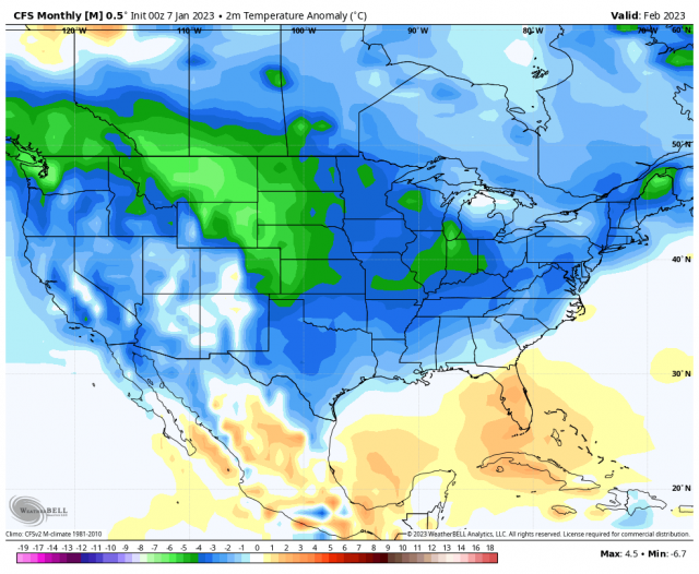
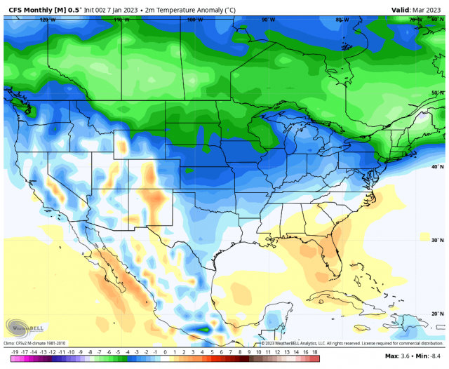
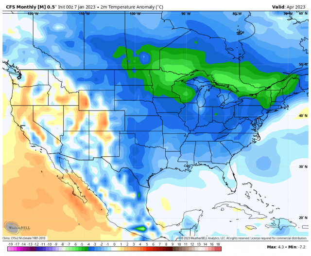
My own 'theory' here is that the MJO moving out of the Maritime Continent into the W Pacific combined with elevated EAsia Mtn Torq (+EAMT) in the mid-late Dec period to over-extend the Pac Jet, leading to this Super Nino-like period we are experiencing now which reminds me of the Super Nino winter of 1998 where there were numerous east coast storms, but no cold air.

Over the next couple weeks, we are going to see the opposite occur.....the MJO influence on the extended jet should relax some as the MJO moves off to the east. Also, we now have an ongoing -EAMT period here for the first half of Jan. So, the Pac Jet is going to weaken

But then we get to the part where we may have some promise for a colder pattern. The next big Siberian High forms and drops into EAsia (renewed +EAMT), extending the Pac Jet back out to the money spot for western ridging near Hawaii. So, hopefully this time, the +EAMT runs the show for the most part without heavy MJO influence, preventing the Pac Jet from over-extending and giving us a colder profile in the last 1/3 of Jan.

1st Loop: Siberia High
2nd Loop: Pac Jet over-extended flipped to Hawaii Day 1 to Day 15
3rd Loop: Gulf of Alaska Low flipped to Aleutian Low Day 1 to Day 15

Anyway, those are some thoughts on a cloudy Saturday morning. It feels a bit slimy to be hanging out in long range land with the way things have gone, but what the heck


kN2luTM.gif


jdDEcn9.gif


AZxag1m.gif
 
Pretty solid GFS run for western facing slopes, CMC looks great as well with UL energy swinging in with over 24 hours of NW flow snow View attachment 129659View attachment 129660
I’m torn right now. Nothing really available for 1 night around Beech sugar other than a couple $400 rooms but I can get a good Hilton friends and family rate in Cherokee then go skiing Sunday morning at Cataloochee 15 minutes away. Plus I can go gamble at Harrahs Saturday night. Cherokee is just such a bad spot..
 
I’m torn right now. Nothing really available for 1 night around Beech sugar other than a couple $400 rooms but I can get a good Hilton friends and family rate in Cherokee then go skiing Sunday morning at Cataloochee 15 minutes away. Plus I can go gamble at Harrahs Saturday night. Cherokee is just such a bad spot..
What about the Gatlinburg area ?
 
I have a cabin in Gatlinburg that we have stayed at twice and its right around 2900 feet up (right next to over gatlinburg). I am close to biting on it. We have been twice for 2-4 inch Northwest flow events and it was perfect.
 
Not how I wanted peak climo to go this year. But hey on the bright side next year will be a nino and I prefer that over these Nina's.
Not me if its a mod to strong Nino, we get flooded/overwhelmed with pacific air continously. Fight same demon we are fighting now. Low grade nino, will usually bode well.

Buffalo has had over 96 inches of snow so far. This was totals on Christmas day. They where at 96.
 

Attachments

  • 1673111546396.png
    1673111546396.png
    1.1 MB · Views: 39
I’m torn right now. Nothing really available for 1 night around Beech sugar other than a couple $400 rooms but I can get a good Hilton friends and family rate in Cherokee then go skiing Sunday morning at Cataloochee 15 minutes away. Plus I can go gamble at Harrahs Saturday night. Cherokee is just such a bad spot..
Go to yancy or mitchell county. Between the avery county slopes and wolf laurel in madison county
 
Seasonal snowfall…95 crew, DC to PHL to NY to BOS is bleak.

View attachment 129662
Still very early overall but that is an amazingly sparse map for the whole Southern Appalachian region; Eastern KY and TN, Western VA and NC, even Southern WV with just a trace to an inch or two. Much of Kansas very little, even just 3-6 inches for much of MO to OH and WV. So far this has been feast for those in the West and North of 40 Lat, and famine elsewhere. Check out Long Island!
 
Try this map Jimmy. Zoom in an move around. The little red dots are cabins avaiable I beleive. Some have price listed, but the red dots are the ones you need to search. Not so much the ones with price tags. Play around, move map.Good luck and post pics for us poor folks.

 
Try this map Jimmy. Zoom in an move around. The little red dots are cabins avaiable I beleive. Some have price listed, but the red dots are the ones you need to search. Not so much the ones with price tags. Play around, move map.Good luck and post pics for us poor folks.

I’m poor too ? that’s why I’m eyeing that $130 room in Cherokee

Just tell me it’s going to snow there and I’ll go ?
 
I’m poor too ? that’s why I’m eyeing that $130 room in Cherokee

Just tell me it’s going to snow there and I’ll go ?
There’s plenty of things to bet on in Cherokee especially with their new sports gambling area but snow sure isn’t one of them lol
 
Ice in Michigan with latest Euro
 
To bad it’s cmc

The signal on this has been there for quite a while now. I even mentioned this very potential a few weeks ago (granted it’s occurring significantly later than I thought it would initially).

Rossby waves are always trying retrograde against the mean flow as a way to balance earth’s rotation, however horizontal advection by the background flow causes them to translate eastward on shorter time scales especially. The larger and more amplified a Rossby Wave is, the greater the beta effect is & the more likely it will retrograde against the mean flow and that’s exactly what’s occurring here in this model forecast, which causes a +PNA and possibly a -EPO beyond this forecast valid time. Unlike synoptic scale Rossby Waves, these larger scale planetary waves evolve very slowly over many weeks of time and are predictable at the kind of scales we’re concerned with here. Their coupling with tropical convection is also thought to contribute to the MJO phenomena, making it distinctive from its close cousin, the Convectively coupled Kelvin Wave.

Eventually, this trough will retrograde so far west (as is again typical for highly amplified large scale waves like this) that this downstream ridge will mirror it/follow suit and end up closer to the Gulf of Alaska & Aleutians, setting up a more classic La Niña/-PNA/SE ridge pattern, probably in early February or so.
 
Those guys on the opposite end of the bathtub than us, have been in the deep freeze and look to stay in it as far as the eye can see. Never changes. Heres last frame on the gfs 12z today. No signs of any sloshing back this way,outside of ones Grit had to dig around to find. Maybe Gefs and eps can start sniffing something out ,like geps is trying to.

1673117673652.png
 
Those guys on the opposite end of the bathtub than us, have been in the deep freeze and look to stay in it as far as the eye can see. Never changes. Heres last frame on the gfs 12z today. No signs of any sloshing back this way,outside of ones Grit had to dig around to find. Maybe Gefs and eps can start sniffing something out ,like geps is trying to.

View attachment 129665
EPS already started showing this yesterday. Long range or even medium range GFS is the most unreliable tool out there. Best not to use
 
EPS is about twice as aggressive as the gefs in regards to the NWFS next weekend for the mountains. I am not comfortable enough to pull the trigger yet. I have seen these NWF setups either dry up or ramp up. Hopefully there will be better agreement over the next 48 hours. Both the GEFS and eps have members with nothing and some up to 6 inches. Quiet a spread.
 
Latest HRRR seems to be speeding up the precip shield into central NC. Dews will be in the mid/upper 20s and temps mostly in the mid 30s. That's not cold enough for much freezing rain concerns, but we could see some pockets of sleet. Not much but it's something.

20z HRRR tomorrow morning:
1673128671259.png
 
Back
Top