Downeastnc
Member
Both would be devastating to the beaches as it crawls along. Still a million miles from a final call as we wait to see where it develops
No longer any stalling just slowBoth would be devastating to the beaches as it crawls along. Still a million miles from a final call as we wait to see where it develops

The Canadian has actually been fairly consistent with that further west track. It would actually make sense given how stout the Bermuda high is, but I’m not sure how well it’s done in the past with tracks of tropical systems6z Canadian at hour 84:
View attachment 149149
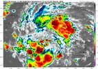
Right now i think if anything a more right path seems likely. Still a good chance whatever it is after FLA will come in just west of Hatteras.By tomorrow afternoon this should start feeling a little bit of help from the right entrance of the jet across the eastern US. I would assume that will be when it starts to get a little more persistent convection and begins to lose the negative impacts of its interaction with Cuba. This would give some lean to the right biased models of the last 24 hours as the system would have a tendency to bend toward the convection north and northeast of any developing system. The convective structure this morning is interesting with the 2 areas well removed from each other. If that southern blob near Jamaica were to take over it may have some impacts to bias the track left in time. Again still somewhat messy on the eventual track and strength
2 areas well removed from each other......By tomorrow afternoon this should start feeling a little bit of help from the right entrance of the jet across the eastern US. I would assume that will be when it starts to get a little more persistent convection and begins to lose the negative impacts of its interaction with Cuba. This would give some lean to the right biased models of the last 24 hours as the system would have a tendency to bend toward the convection north and northeast of any developing system. The convective structure this morning is interesting with the 2 areas well removed from each other. If that southern blob near Jamaica were to take over it may have some impacts to bias the track left in time. Again still somewhat messy on the eventual track and strength

My understanding is that it record with tropical systems is poor. That said, watch it be correct this time.The Canadian has actually been fairly consistent with that further west track. It would actually make sense given how stout the Bermuda high is, but I’m not sure how well it’s done in the past with tracks of tropical systems
