• Hello, please take a minute to check out our awesome content, contributed by the wonderful members of our community. We hope you'll add your own thoughts and opinions by making a free account!

Hurricane Debby

Even though we’re technically still in drought, the Great Pee Dee, Little Pee Dee and Lumber Rivers are all currently out their banks as I’ve seen the last couple of days. Not by much but enough to submerge the bottomlands. Even a mild area wide rain event would push them into structures without much trouble.
 
That stalling solution would probably cut an inlet all the way to Avon from the corner at Buxton in the Outer Banks. It’s already hanging on for dear life right there.
I was at Holden Bach Sunday and there is already a cliff of sand where high tides are cutting deeper into the beach. At high tide the beach is only 30 yards wide there
 
I was at Holden Bach Sunday and there is already a cliff of sand where high tides are cutting deeper into the beach. At high tide the beach is only 30 yards wide there
Yea the closer you get to Cape Fear the beaches are in bad shape. The current pulls the sand south so strangely if you go to Sunset Beach it’s been growing for decades. At low tide it’s wild how broad the beach is.
 
This thing gets good enough and we are in a state of emergency for a couple weeks and I work…. I might get paid anywhere from 10-20k on my check and that’s being conservative … emergency pay plus regular pay plus overtime plus extended shift …. Emergency pay is absurd , I know someone who got a 4K dollar check back when we made like 10 dollars an hour less just for working a snowstorm for 4 days or somin… hell all I need is 3-4 days emergency pay and I’m prolly looking at a 7k dollar check
 
40 / 70

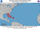
two_atl_7d0 (9).png

Tropical Weather Outlook
NWS National Hurricane Center Miami FL
800 PM EDT Thu Aug 1 2024

For the North Atlantic...Caribbean Sea and the Gulf of Mexico:

1. Straits of Florida and Eastern Gulf of Mexico (AL97):
A well-defined tropical wave is producing a large area of
disorganized showers and thunderstorms over Hispaniola, the
southeastern Bahamas, and the adjacent waters of the southwestern
Atlantic. The wave is expected to move west-northwestward near or
over Cuba on Friday and then emerge over the Straits of Florida
Friday night or Saturday. Environmental conditions are expected to
be conducive for additional development after that time, and a
tropical depression is likely to form this weekend over the Straits
of Florida or eastern Gulf of Mexico near the Florida Peninsula.

Regardless of development, heavy rains could cause areas of flash
flooding across Florida, Cuba, and the Bahamas through the weekend,
and interests in these locations should continue to monitor the
progress of this system. A NOAA Hurricane Hunter aircraft is
scheduled to investigate this system on Friday, if necessary.
* Formation chance through 48 hours...medium...40 percent.
* Formation chance through 7 days...high...70 percent.
 
18z HWRF.....Further east than 12z......and it sits over south GA for 2 days.


hwrf_ref_97L_fh84-84.gif
 
Last edited:
82ca72bc5ac56c3f724f6be3b7b8446d.jpg


Sent from my iPhone using Tapatalk
 
Back
Top