GSP is riding the WPC forecast for now, sticking to widespread 4-6” but mentions a localized 8-9” total is expected
-
Hello, please take a minute to check out our awesome content, contributed by the wonderful members of our community. We hope you'll add your own thoughts and opinions by making a free account!
You are using an out of date browser. It may not display this or other websites correctly.
You should upgrade or use an alternative browser.
You should upgrade or use an alternative browser.
Tropical Hurricane Sally Inland Effects
- Thread starter SimeonNC
- Start date
Bannerdude
Member
Impressive swath of flood watches/warnings

NoSnowATL
Member
Yep like I thought. My guess is 2-4 but hope 3-5 is possible. Kirk Mellish is thinking 1-3 for most areas but 2-4 SE areas with 6in in spots.00z Euro has heaviest rainfall just south of I-85 with 4-7 inches from Georgia into the Carolinas.View attachment 48746
smast16
Member
Only 3"-4" of rain for me in the latest guidance. I was going to put out grass seed, but i'm thinking i'll just put it all in a line at the top of the hill now, and let the deluge wash into the yard. lol
Not sure if anyone noticed this..but here I’m under a Flood Watch. That’s a big difference compared to a Flash Flood Watch areas further south are under according to the NWS.
1-3 inches in 24 hours so failed to meet the criteria of the word “flash” per NWS AFD.
smast16
Member
True, but are you under that WWA yet?Not sure if anyone noticed this..but here I’m under a Flood Watch. That’s a big difference compared to a Flash Flood Watch areas further south are under according to the NWS.
WXinCanton
Member
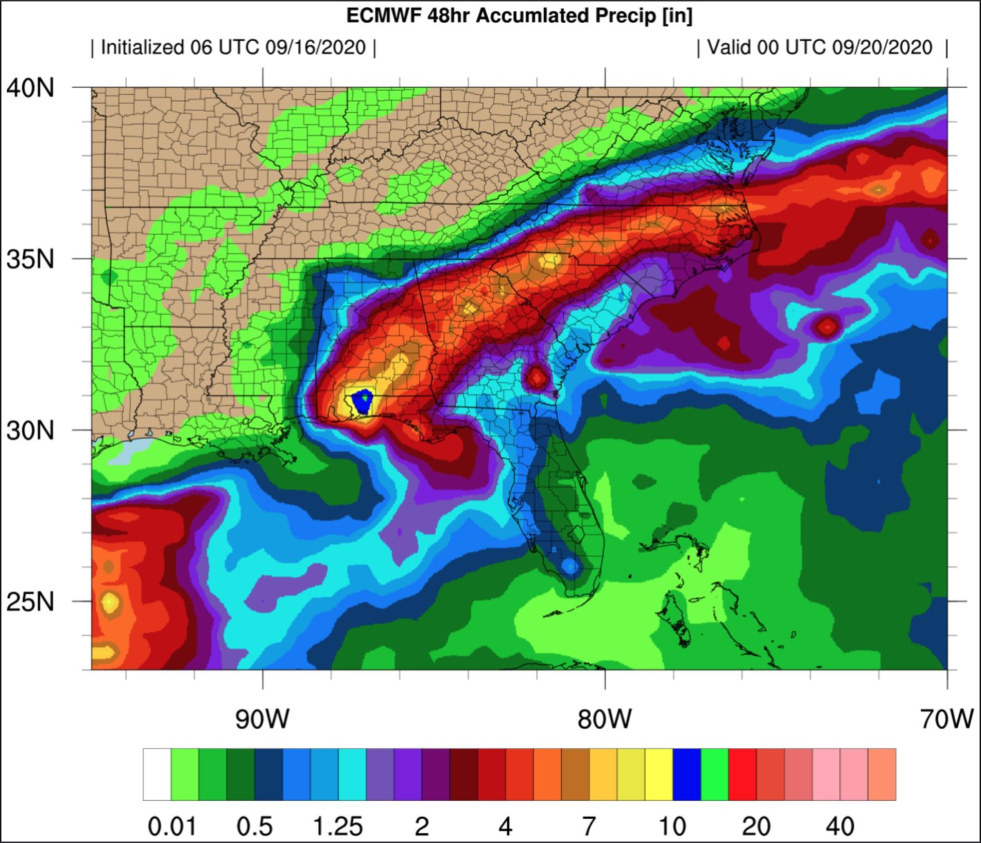
6z euro courtesy Allan Huffman

Allan Huffman
@RaleighWx
·
15m
The 6z ECMWF shows the axis of heaviest rain from Elizabeth City to Raleigh to Charlotte into upstate SC. 4-8 inches possible. #Sally
https://twitter.com/RaleighWx/status/1306212110511353856/photo/1
Allan Huffman
@RaleighWx
·
15m
The 6z ECMWF shows the axis of heaviest rain from Elizabeth City to Raleigh to Charlotte into upstate SC. 4-8 inches possible. #Sally
https://twitter.com/RaleighWx/status/1306212110511353856/photo/1
As [mention]Myfrotho704_ [/mention] pointed out two days ago about the possibility of severe weather in South Carolina and points toward Jacksonville NC. It’s looking more and more a sure thing. The warm Atlantic air mass colliding with a cold front and tropical air mass could cause scattered funnel clouds. Buoyancy will not be particularly strong, though a couple of factors may contribute to pockets of moderate instability, including areas of insolation, which could locally increase MUCAPE values around or above 1000 J/kg in the pre-convective airmass and slightly higher dewpoints/boundary-layer moisture over South Carolina and vicinity due to maritime influences from the Gulf Stream

Sent from my iPhone using Tapatalk

Sent from my iPhone using Tapatalk
15” lollipop just to my southwest ?00z Euro has heaviest rainfall just south of I-85 with 4-7 inches from Georgia into the Carolinas.View attachment 48746
00z EPS came in hot for Spartanburg county

- Joined
- Jan 5, 2017
- Messages
- 3,769
- Reaction score
- 5,966
HRRR latest 12z shows around 2" to 2.5" for most of Atlanta. I'm thinking around 2" to 3" for my area. I don't believe the Euro output. Watching trends to the SW for sure. This won't make any flash flooding as it's been several weeks without measurable rainfall.Yep like I thought. My guess is 2-4 but hope 3-5 is possible. Kirk Mellish is thinking 1-3 for most areas but 2-4 SE areas with 6in in spots.
BufordWX
Member
12z Nam looks to have shifted the rain a tad bit north again in Georgia.
SnowNiner
Member
6z euro courtesy Allan Huffman
Allan Huffman
@RaleighWx
·
15m
The 6z ECMWF shows the axis of heaviest rain from Elizabeth City to Raleigh to Charlotte into upstate SC. 4-8 inches possible. #Sally
Going to just sit here quietly and imagine that's a 48 hour snowfall map in inches. With that being the case, I'll estimate about 50% of what's shown to be reality. For MBY anyway.
BufordWX
Member
Is it me or did the NHC nudge the track north in the latest advisory?
Jessy89
Member
Is it me or did the NHC nudge the track north in the latest advisory?View attachment 48778
Yeah they did go north. That about matches the latest Nam model which is north
Sent from my iPhone using Tapatalk
If it was winter I would love where I was because usually the heaviest always ends up 1-3 counties further north than shown. But in this case I do believe 1-3 counties south of me so southern Iredell to Charlotte could see those 2-4” amounts.Going to just sit here quietly and imagine that's a 48 hour snowfall map in inches. With that being the case, I'll estimate about 50% of what's shown to be reality. For MBY anyway.
Going to just sit here quietly and imagine that's a 48 hour snowfall map in inches. With that being the case, I'll estimate about 50% of what's shown to be reality. For MBY anyway.
C’mon man... 4-8” possible for Elizabeth City? Dude, my yard is a swamp as it is.
IDK why..I’m just never a fan of these too many color maps. Esp when upslope can be triggered in the north faster than down East they usually out to lunch. 
SnowNiner
Member
C’mon man... 4-8” possible for Elizabeth City? Dude, my yard is a swamp as it is.
Hurricane Sally, think you better slow your mustang down.....
BufordWX
Member
This is what FFC has near my area back home. Looks a little wet...
- Joined
- Jan 5, 2017
- Messages
- 3,769
- Reaction score
- 5,966
Also showing another 1004 mb low in the gulf at the end of the run. A second gulf low would not be good so closely following a big rain event.12z Nam looks to have shifted the rain a tad bit north again in Georgia.
Avalanche
Member
Hurricane Sally, think you better slow your mustang down.....
A Wilson Pickett fence to contain this rainfall.
That would be the real problem child. The 6z GFS and the 0z Canadian (to some degree) also showed another storm hit.Also showing another 1004 mb low in the gulf at the end of the run. A second gulf low would not be good so closely following a big rain event.
NBAcentel
Member
Damn gfs would be some big flooding issues, also temps stuck in the 50s so it would be our first “cold rain” since May
NoSnowATL
Member
First real rain bands moving into Atlanta right now. The drive home tonight should be fun.
Tornado threat still looks fairly legit tomorrow afternoon across a good part of central/eastern SC into southern parts of NC. Some of the soundings out of the midlands are pretty crazy
Even farther north toward this area a severe storm can't be ruled out a decent amount of ML CAPE should lead to some elevated convection, 925 mb winds around 35-40kt 850 kt 45-50kt could be forced down in some of the convection. Also notice that PWAT of 2.35, really going to squeeze out some heavy rainfall tomorrow afternoon through early Friday

NBAcentel
Member
Tons of 3CAPE/low LCLs is gonna allow anything that spins to be a real threat tomorrowTornado threat still looks fairly legit tomorrow afternoon across a good part of central/eastern SC into southern parts of NC. Some of the soundings out of the midlands are pretty crazyView attachment 48787
Yep I'm not sure if I favor down toward the midlands or up closer toward the border where the low level winds will be really backed closer to the remnant LLC. Looks like some areas south of the "warm front" may end up getting into a little sun tomorrow too, yikesTons of 3CAPE/low LCLs is gonna allow anything that spins to be a real threat tomorrow
BufordWX
Member
End of the last few HRRR runs are also shifting the heavier rain northward a little.
I think it’s going to be bad around metro ATL. First bands have hit this morning and it is a soaking rain. Lots of water..... the radar is filling in to the south fast.
Jessy89
Member
It’s more now casting time then model watching time.
Sent from my iPhone using Tapatalk
Sent from my iPhone using Tapatalk
it was way too far SE initiallyEnd of the last few HRRR runs are also shifting the heavier rain northward a little.View attachment 48794

- Joined
- Jan 5, 2017
- Messages
- 3,769
- Reaction score
- 5,966
You can't tell from radar, but the rain is pretty constant, already, just south of the airport. Trending toward the Euro? I hope not.First real rain bands moving into Atlanta right now. The drive home tonight should be fun.
WXinCanton
Member
GFS pops another LP on Sunday in pretty much the same path as Sally.
NoSnowATL
Member
Yea it’s a steady light to moderate rain here at the Atlantic Station.You can't tell from radar, but the rain is pretty constant, already, just south of the airport. Trending toward the Euro? I hope not.
We'll be lucky to get a half inch of rain up here, the way things are looking now... oh well.
BufordWX
Member
I could see a quick half inch or more of rain for folks that end up under this developing outer band.