Snowflowxxl
Member
Been a steady light rain for the last two hours.

It looks to me like much of the NW metro is in the 2-3" range ?The 12Z GEFS has come off the ~5" the mean was showing on prior GEFS runs for KATL, but it still is nearly 4" there and nearly all of ATL metro is in the 3-4" range:
View attachment 48795
Also posted this showing 1-2 inches of rain for Atlanta.From our buddy Glenn Burns
Some significant changes with Sally.
1. Storm is on shore and weakening rapidly
2. Slight track change slightly to the northeast (no impact change)
3. MOVING MUCH FASTER than the NHC thought yesterday.
Bottom line is that the rapid weakening and accelerated forward speed means MUCH LESS RAIN and the RAIN ENDING FASTER. Most of it ends around dawn tomorrow. Will be getting new models for rainfall shortly...now looks like 1-3" from what I can tell now. Waiting for further info to be sure.

BustFrom our buddy Glenn Burns
Some significant changes with Sally.
1. Storm is on shore and weakening rapidly
2. Slight track change slightly to the northeast (no impact change)
3. MOVING MUCH FASTER than the NHC thought yesterday.
Bottom line is that the rapid weakening and accelerated forward speed means MUCH LESS RAIN and the RAIN ENDING FASTER. Most of it ends around dawn tomorrow. Will be getting new models for rainfall shortly...now looks like 1-3" from what I can tell now. Waiting for further info to be sure.
It looks to me like much of the NW metro is in the 2-3" range ?
")
Also posted this showing 1-2 inches of rain for Atlanta.View attachment 48810
I don’t know about anyone else, but this feels a little too low. I think 2-4 is a safe bet in the metro right now.
From our buddy Glenn Burns
Some significant changes with Sally.
1. Storm is on shore and weakening rapidly
2. Slight track change slightly to the northeast (no impact change)
3. MOVING MUCH FASTER than the NHC thought yesterday.
Bottom line is that the rapid weakening and accelerated forward speed means MUCH LESS RAIN and the RAIN ENDING FASTER. Most of it ends around dawn tomorrow. Will be getting new models for rainfall shortly...now looks like 1-3" from what I can tell now. Waiting for further info to be sure.
Going off the euro it could be a little higher then that, but I think at least 2-4 sound reasonable.Glen Burns gonna bust bad. 2-4 inches is a lock for ATL.
Yeah I haven’t really been too worried about the severe threat here while tracking this, but it definitely looks like a possibility now at least for those of us the southeast part of CLT metroI don’t know about you all, but I’m curious to see how this storm completely skips over JHS’s house while soaking the rest of the state and region. It’s gonna be one for the books!
But in all seriousness, flooding is going to be a major problem tomorrow into Friday. Not looking forward to those commutes! And the tornado threat looks to be legit, possibly for CLT and RAH. All depends on the track.
Sent from my iPhone using Tapatalk
Glen Burns gonna bust bad. 2-4 inches is a lock for ATL.

I have Dish now and since they canceled we no longer get to watch Glenn Burns(breaks my heart ?). What is/was he forecasting for Atl? I live in Walton county about 20 min west of Athens Ga and we got a good bit of rain yesterday morning as well kind of indirectly from Sally.Glen Burns gonna bust bad. 2-4 inches is a lock for ATL.
I'm inside the perimeter.....been a steady rain since about 11.....not much wind at all....yet.Looks like Atlanta is already entering the big rain mass. Gonna be a wet evening...View attachment 48823
Wind advisory doesn’t go into effect until 6:00 PM.I'm inside the perimeter.....been a steady rain since about 11.....not much wind at all....yet.
Yeah, saw that.....it should be interesting...Wind advisory doesn’t go into effect until 6:00 PM.
1-3 inchesI have Dish now and since they canceled we no longer get to watch Glenn Burns(breaks my heart ?). What is/was he forecasting for Atl? I live in Walton county about 20 min west of Athens Ga and we got a good bit of rain yesterday morning as well kind of indirectly from Sally.


I’ve got to be honest, I’ve personally never watched him and looked into how accurate his forecasts are. I know him mostly from following these boards and seeing posts from folks in the Atlanta area, and of course I know just how horrendous his call was on the storm that lead to the 2014 Snowjam. Here, I can’t imagine what he means about the storm moving much faster than expected... at the last advisory it was only moving 5mph.Glenn Burns is a tool
That cutoff is brutal for NW Georgia.. Dalton/Calhoun may see 4 inches, while Chattanooga gets blanked...The NAM certainly does not agree with Glenn Burns.View attachment 48832
The main area of rain hasn’t arrived yet and I’ve already received .54”, so we will see the predictions that come to fruition.That cutoff is brutal for NW Georgia.. Dalton may see 4 inches, while Chattanooga gets blanked...


Believe it or not, the 3km upped soundings for tomorrow, getting in the range of soundings supportive of perhaps a stronger tornado View attachment 48835View attachment 48836
Where are these soundings from?
Sent from my iPhone using Tapatalk


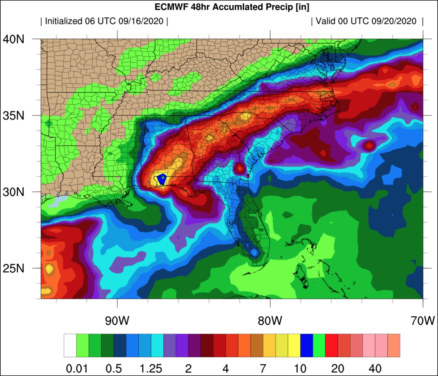
6z euro courtesy Allan Huffman
Allan Huffman
@RaleighWx
·
15m
The 6z ECMWF shows the axis of heaviest rain from Elizabeth City to Raleigh to Charlotte into upstate SC. 4-8 inches possible. #Sally