Z
Zander98al
Guest
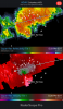
Velocity couplet for that tornado warned storm. Could drop one any time. With how tight the couplet is.

Tornado watch until 4:00 PM CDT for parts of Mississippi, Alabama, and Tennessee.Tornado watch may be coming soon...View attachment 47592


They continue strengthening and tightening up?Yikes

Double springs is incredible with the structure


Yep highly doubt we see much of anything today
That rain is moving in quick, I just don't see it clearing to allow sufficient destabilization.Decent cape values out there already on the spc meso. Just not sure it'll matter
Wind profiles sure support it and sbcape is actually a little higher than forecast but I'm no severe weather guy and I'm sure there's another parameter that will limit severe development. Lapse rates seem meager, maybe that's the issue or maybe things actually go boom this way later.....I'm really not sure hahaThose clouds are booking it. Kind of cool to see, even though we probably aren't going to get any significant weather.
Yeah wind profiles are healthy but forcing is meager and vertical acceleration is going to be lacking, for the most part.Wind profiles sure support it and sbcape is actually a little higher than forecast but I'm no severe weather guy and I'm sure there's another parameter that will limit severe development. Lapse rates seem meager, maybe that's the issue or maybe things actually go boom this way later.....I'm really not sure haha
Wind profiles sure support it and sbcape is actually a little higher than forecast but I'm no severe weather guy and I'm sure there's another parameter that will limit severe development. Lapse rates seem meager, maybe that's the issue or maybe things actually go boom this way later.....I'm really not sure haha
6z Nam is dry as a bone. I hate that model. So much.Have to say the 0z CAMs 6z NAMs and even 12z HRRR are doing a pretty cruddy job vs reality. This initial band approaching us1 will likely stabilize things but it's coming in early. It'll be gone by noon and we may be back into sun. As the actual trough axis approaches later today we might see things line up
Yeah it just evaporated all the rain at like 3 hrs. The radar is actually far more impressive than I expected with the showers back to the mountains.6z Nam is dry as a bone. I hate that model. So much.
It's really astounding to me that with all of the technology available today, that is the best we can do from a mesoscale weather model standpoint.Yeah it just evaporated all the rain at like 3 hrs. The radar is actually far more impressive than I expected with the showers back to the mountains.