Cary_Snow95
Member
NHC has decreased 2/5 day development odds by 10%

Yeah I’m just gonna say it now that ain’t gonna happen6Z GEFS: slightly higher risk to mainly NC vs 0Z but still nothing to write home about with most recurving offshore
View attachment 45159
The reflection of 92L in the gulf on the euro is similar to what it depicted for Hanna several days out and that ended up being a hurricane. Gigantic waves like this aren’t going to just roll over and die after hitting Hispaniola.Gfs and euro are lockstep with strength mostly. Main difference is euro takes the very weak wave over Hispaniola and completely shreds it
What is your current prediction for how this unfolds? Are you favoring a strengthening system in the Bahamas by Saturday?The reflection of 92L in the gulf on the euro is similar to what it depicted for Hanna several days out and that ended up being a hurricane. Gigantic waves like this aren’t going to just roll over and die after hitting Hispaniola.
Here, since we're close enough in time, you can view the data at weathernerds.org.Could someone post the eps once it’s out

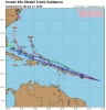
In comparison to 00z, the storm has a larger spread going north, however, almost all are weak.Here, since we're close enough in time, you can view the data at weathernerds.org.
https://www.weathernerds.org/tc_guidance/storm.html?tcid=AL92View attachment 45194


Here, since we're close enough in time, you can view the data at weathernerds.org.
https://www.weathernerds.org/tc_guidance/storm.html?tcid=AL92View attachment 45194
And moving into the gulf18z GFS a bit concerning. Holds together and gets to the Bahamas. Has a weak system sitting right off of the Florida coast
Not really, that’s only because the further towards the surface you get, the less sheared it will be. If you look at the z500 vort, you notice there is nothing left, due to shear that is usually much higher up.18z GFS a bit concerning. Holds together and gets to the Bahamas. Has a weak system sitting right off of the Florida coast


Not really, that’s only because the further towards the surface you get, the less sheared it will be. If you look at the z500 vort, you notice there is nothing left, due to shear that is usually much higher up.
Here’s 500mb level
View attachment 45211
here’s 850mb
View attachment 45212

The 12z run is even more laughable!I don’t know how accurate it is but it surprised me when I saw it. Here’s the 18z NAVGEM. (I’m sorry in advance if it’s complete garbage)
View attachment 45216


For some reason last few years long range models always want to have a hurricane on the east coast taking they most unlikely path and running up into Georgia from Savannah or Jacksonville .The 12z run is even more laughable!
View attachment 45217
For some reason last few years long range models always want to have a hurricane on the east coast taking they most unlikely path and running up into Georgia from Savannah or Jacksonville .


Webb said large waves just dont go awayNo circulation/weaker system like this can survive going over land/mtns better than a tight hurricane that can get unraveled. Not saying it will, but have seen many storms wait till the western Caribbean before bombing out.

00z GEFS
View attachment 45233

.png")
Um the Euro isn't killing it off anymore it's weak but it tracks across the Keys and into the gulf this runView attachment 45234View attachment 45235