Here are the ensemble plumes.
View attachment 45126
Thanks. Just as suspected. The vast majority stay well south (N Caribbean/Greater Antilles) and are weak (green tracks).
Here are the ensemble plumes.
View attachment 45126

Shower activity is becoming a little better organized in
association with a broad area of low pressure located over the
central tropical Atlantic about midway between the coast of Africa
and the Lesser Antilles. Environmental conditions are expected to
become increasingly conducive for development of this system, and a
tropical depression or tropical storm is likely to form within the
next day or two while moving westward to west-northwestward at
15 to 20 mph. This system is expected to begin affecting portions
of the Lesser Antilles on Wednesday or Wednesday night, and
interests on those islands should continue to monitor its progress.
* Formation chance through 48 hours...high...80 percent.
* Formation chance through 5 days...high...90 pe

View attachment 45136
18z GEFS with a big East shift


Interesting to note that the few members that are north towards the N.C. coast are the weak ones that never make it above a tropical storm
Here’s the spaghetti plots from Ryan Maue’s site. He did literal translations for each.Forgive me if I’m wrong but isn’t the AVNI the GFS spaghetti model and the AEMI the GEFS spaghetti model?


Euro is unchanged. Dissipates the storm south of the islands
Easy recurve well east on the 0Z GFS and now we're within 6-7 days. Still no need for big SE concern at this time thankfully, whether it be an easy recurve or staying far south and weak:
View attachment 45153
The GFS always breaks down the subtropical high too quickly and simply looks unrealistic in general.
Just waking up. Looks like a trend to a weaker system overnight. Satellite imagery of 92L looks better than yesterday but still extremely spread out. This circulation is so broad it might be a while for it to get its act together. It’s definitely racing the clock as it pushes towards the islands, as a path below the islands is a death sentence for it.

It looks like the models that develop this get deep convection going on the north end of the wave axis then basically have a center chasing convection or a northerly lopsided system. This helps to bias the track north and fast which allows it to arrive in the SW Atlantic while the NE trough and upper low are still connected thus the east track. The 0z cmc was a good example of how close the timing is with the bend back toward the US at the end.Just waking up. Looks like a trend to a weaker system overnight. Satellite imagery of 92L looks better than yesterday but still extremely spread out. This circulation is so broad it might be a while for it to get its act together. It’s definitely racing the clock as it pushes towards the islands, as a path below the islands is a death sentence for it.
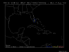
0Z GEFS: 2 hit NC (10%), 2 skirt NC coast (10%), and pretty much the rest recurve offshore. Here is the 120 hour precip map, showing the heaviest offshore and the highest risk, if there is impact onshore, to E NC, pretty similar to earlier runs:
View attachment 45156