Yeah 0Z ECMWF was a little West of the 12Z run
It brought the center right over Wake County.
Yeah 0Z ECMWF was a little West of the 12Z run
Wilkes will with trough to the west and TS upslope combination.Wilkes ain’t getting 2-4” from a weak TS going over SD and RC, sorry Larry
All about that upslope.Wilkes ain’t getting 2-4” from a weak TS going over SD and RC, sorry Larry
Seems very vulnerable to dmin and dmax times with intensity flare ups.This storm is something else....it went from looking like something you'd throw out with the garbage to developing what looks like a northern eyewall again in less than 2 hours
 with upslope according to WPC and Raysweather. A little minimum East of here near upstate SC and Charlotte.
6z HWRF blasts central NC.
Also, tropical storm watches have been issued for Scotland, Hoke, Cumberland, & Sampson counties. Expecting those to get expanded northward pretty soon.
View attachment 45787
How is the East SC looking in terms of radar simulation?6z HWRF blasts central NC.
Also, tropical storm watches have been issued for Scotland, Hoke, Cumberland, & Sampson counties. Expecting those to get expanded northward pretty soon.
View attachment 45787
How is the East SC looking in terms of radar simulation?

@Webberweather53 it looks like it shifted west from 0Z to affect more of SC.
WTNT34 KNHC 021157
TCPAT4
BULLETIN
Tropical Storm Isaias Intermediate Advisory Number 21A
NWS National Hurricane Center Miami FL AL092020
800 AM EDT Sun Aug 02 2020
...HEAVY RAINFALL AND GUSTY WINDS CONTINUE OVER THE NORTHWESTERN
BAHAMAS...
...TROPICAL STORM CONDITIONS CLOSE TO THE EAST COAST OF FLORIDA...
SUMMARY OF 800 AM EDT...1200 UTC...INFORMATION
----------------------------------------------
LOCATION...26.5N 79.5W
ABOUT 40 MI...70 KM ESE OF WEST PALM BEACH FLORIDA
ABOUT 155 MI...245 KM SSE OF CAPE CANAVERAL FLORIDA
MAXIMUM SUSTAINED WINDS...65 MPH...100 KM/H
PRESENT MOVEMENT...NW OR 325 DEGREES AT 8 MPH...13 KM/H
MINIMUM CENTRAL PRESSURE...996 MB...29.42 INCHES
WATCHES AND WARNINGS
--------------------
CHANGES WITH THIS ADVISORY:
The Hurricane Warning for the Northwestern Bahamas has been
discontinued.
SUMMARY OF WATCHES AND WARNINGS IN EFFECT:
A Storm Surge Watch is in effect for...
* Jupiter Inlet to Ponte Vedra Beach Florida
* Edisto Beach South Carolina to Cape Fear North Carolina
A Tropical Storm Warning is in effect for...
* Hallandale Beach Florida to South Santee River South Carolina
* Lake Okeechobee
A Tropical Storm Watch is in effect for...
* North of South Santee River South Carolina to Surf City North
Carolina
Interests elsewhere along the southeast and mid-Atlantic coasts of
the United States should monitor the progress of Isaias. Additional
watches or warnings may be required later today.
A Storm Surge Watch means there is a possibility of life-
threatening inundation, from rising water moving inland from the
coastline, in the indicated locations during the next 48 hours.
For a depiction of areas at risk, please see the National Weather
Service Storm Surge Watch/Warning Graphic, available at
hurricanes.gov.
A Tropical Storm Warning means that tropical storm conditions are
expected somewhere within the warning area, generally within 36
hours.
A Tropical Storm Watch means that tropical storm conditions are
possible within the watch area, generally within 48 hours.
For storm information specific to your area in the United
States, including possible inland watches and warnings, please
monitor products issued by your local National Weather Service
forecast office. For storm information specific to your area
outside of the United States, please monitor products issued by
your national meteorological service.
Thanks for posting by any chance you have a qpf map from the 6z Euro too?
Thanks for posting by any chance you have a qpf map from the 6z Euro too?


Sorry man, we posted that at the same time.... it really looks less pathetic atm
Current IR sat looks eerily similar....It is worth noting that if the HRRR is right again (as it had Isaias starting to look better around this time) it has Isaias looking like this in about 11 hours:
View attachment 45754
And has some steady development through the night, so we'll see what happens.
Looks like Isaias's low level center is reforming downshear this morning, could have track implications in the Carolinas if it manages to stick the landing.
This would mean a stronger storm? Could this mean a further east track?
Is it possible that rather than reformation it just gets decoupled again?It could mean both here, but I'm somewhat doubtful it'll be able to hold on for too terribly long.


.png")

Imo, Tropical Storm Hanna (2008) is a pretty good analog for what we can generally anticipate area-wide w/ Isaias tomorrow night into Tuesday morning in the Carolinas.
Imo, Tropical Storm Hanna (2008) is a pretty good analog for what we can generally anticipate area-wide w/ Isaias tomorrow night into Tuesday morning in the Carolinas.
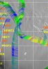
There is a period of time where this system is E of the Ga coast and the shear backs off a little bit. At the same time you have the system in the right entrance of the jet. This would be the window for quick intensification as well as blossoming a large precip shield north of the track. View attachment 45800
As this moves north from here we are likely to see the precipitation shift to LOT toward the trough axis with help from the increasing jet streak to the northView attachment 45802