iGRXY
Member
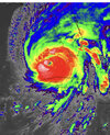
That double eyewall is absolutely filthy now. This thing really could get down into the 920’s
my experience with EWRCs- they look inconclusive in real time but in a few days when they make sped up time lapses of the radar it will look like a textbook EWRC.


And to add insult, larger eyes are much more resistant to dry air.This eye is about to be absolutely massive
It's about to make a run for cat 5 here soon.And to add insult, larger eyes are much more resistant to dry air.

I dont know about Soon usually it’ll take a little once eyewall replacement takes place to continue dropping but I do believe a run at CAT 5 is possible later in the nightIt's about to make a run for cat 5 here soon.
You just quoted what I said but basically reworded it ?I dont know about Soon usually it’ll take a little once eyewall replacement takes place to continue dropping but I do believe a run at CAT 5 is possible later in the night


and it’s at 985mb at that landfall… definitely a landfall as at least a cat 1 hurricane for GA/SC very much on the table18Z Euro second LF near or just south of Savannah, then rides NW on the SC/GA line.
.png")
.png")
The UK track from Charleston inland is quite familiar for many of us in the Carolinas. Of course this one wouldn’t be moving at 35mph.00z Globals
A given of 2nd LF.
Somewhere between Savannah and Charleston.
View attachment 122338
View attachment 122339
SW shear seems to be starting to effect Ian from satellite images I am looking at
And that track has been very consistent. Has been there several runs now before the others started moving east.The UK track from Charleston inland is quite familiar for many of us in the Carolinas. Of course this one wouldn’t be moving at 35mph.


Look at those spinners…
Sent from my iPhone using Tapatalk
00z Globals
A given of 2nd LF.
Somewhere between Savannah and Charleston.
View attachment 122338
View attachment 122339
It’s gonna be a hard turn NW when it does make that second LFI would bet its more Charleston to Wilmington, the storm has consistently been well east of guidance....I foresee a few more east shifts in track for the NHC....
This run is nasty for upstate SC as far as wind goes. Some gusts nearing 60 MPH.18Z Euro second LF near or just south of Savannah, then rides NW on the SC/GA line.
I dont know about Soon usually it’ll take a little once eyewall replacement takes place to continue dropping but I do believe a run at CAT 5 is possible later in the night
Glad your okay ?. It's pretty scaryFirst time in my life I ever experienced a real Tornado. I'm near Davie in Cooper. Craziest Winds that bent trees one way as it was coming from Miami Gardens, and the opposite way as it was leaving west of Davie. Shook the house a bit. My brother had a couple of trees fall in the backyard, and power went out.
The rain was also insane. The lack is overflowing into backyards, and this was the first time I've ever seen my streets flood.
Obviously, I've called all my friends already to tell them about it.

It’s gonna be a hard turn NW when it does make that second LF
Hopefully not, because we sure need the rain in the southeast. After this the models are dry right through day 16.I think we see the models continue to trend away from that hard stall and NW turn....
First time in my life I ever experienced a real Tornado. I'm near Davie in Cooper. Craziest Winds that bent trees one way as it was coming from Miami Gardens, and the opposite way as it was leaving west of Davie. Shook the house a bit. My brother had a couple of trees fall in the backyard, and power went out.
The rain was also insane. The lack is overflowing into backyards, and this was the first time I've ever seen my streets flood.
Obviously, I've called all my friends already to tell them about it.
Just stopHopefully not, because we sure need the rain in the southeast. After this the models are dry right through day 16.