982mb is much more believable than 968mb. The NAM obviously has the tendency to drop pressures too much.
-
Hello, please take a minute to check out our awesome content, contributed by the wonderful members of our community. We hope you'll add your own thoughts and opinions by making a free account!
You are using an out of date browser. It may not display this or other websites correctly.
You should upgrade or use an alternative browser.
You should upgrade or use an alternative browser.
Tropical Hurricane Ian
- Thread starter severestorm
- Start date
-
- Tags
- tropical
Good point...I just looked at the 0z run from last night.Yep..UK has been at Charleston for 3 days and hasn't waivered.

Belle Lechat
Member
- Joined
- Aug 29, 2021
- Messages
- 1,547
- Reaction score
- 1,224
Time : 135020 UTCTime : 125020 UTC
Lat : 26:06:36 N Lon : 82:42:35 W
CI# /Pressure/ Vmax
6.9 / 922mb / 137kts
Final T# Adj T# Raw T#
6.9 6.8 (+.3) 6.8 (+.3)
Last two back to how they were an hour ago.
Lat : 26:17:59 N Lon : 82:42:35 W
CI# /Pressure/ Vmax
6.9 / 922mb / 137kts
Final T# Adj T# Raw T#
6.7 (-.2) 6.6 (-.2) 6.6 (-.2)
raine1212
Member
How large across is Ian in miles, I have never been able to figure that out, Thanks for the CSRA in Georgia
Belle Lechat
Member
- Joined
- Aug 29, 2021
- Messages
- 1,547
- Reaction score
- 1,224
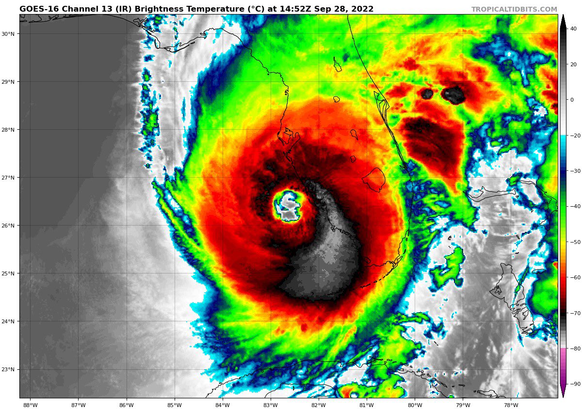
New eye forming?
That Euro run is honestly borderline Category 2 with the pressure at 982mb. Some decisions have to start being made about evacuations for coastal SC, but the NHC still has it a TS
Storm surge flowing in rapidly on Sanibel Island. See traffic camera at Lindgren and East Gulf Drive https://www.mysanibel.com/live-street-cams
Max elevation on Sanibel is 10 feet. The light tower might be the only thing left standing.
Taylor C
Member
Captiva and South Sea Island Resort taking it to the chin.
Extreme wind warning up for landfall. Wow
New eye forming?
It's an odd feature. High-res satellite clearly shows that the swirl is at a high altitude within the eye. No ERC is imminent.
SCWXGuy
Member
Exact same place that Charley struck.Captiva and South Sea Island Resort taking it to the chin.
A ton of new lightning in the eye now
What a bunch of idiots
VegasEagle
Member
Naples Pier Sunset Cam
Live 360-degree views of Gulf of Mexico sunsets and Naples City Docks sunrises. Watch New Year's Eve fireworks from Naples Pier via EarthCam.
 www.earthcam.com
Good cam
Henry2326
Member
Can you see the last pressure forecasted on the UK?982mb is much more believable than 968mb. The NAM obviously has the tendency to drop pressures too much.
Belle Lechat
Member
- Joined
- Aug 29, 2021
- Messages
- 1,547
- Reaction score
- 1,224
What a bunch of idiots
My mom was a lifeguard. She went swimming in a hurricane but "was cured of it" when she was picked up and slammed into the sandy bottom and held down for a minute.
Drizzle Snizzle
Member
What a bunch of idiots
Shocker. They are young males. Bunch of idiots.
Belle Lechat
Member
- Joined
- Aug 29, 2021
- Messages
- 1,547
- Reaction score
- 1,224
Time : 142020 UTCTime : 135020 UTC
Lat : 26:17:59 N Lon : 82:42:35 W
CI# /Pressure/ Vmax
6.9 / 922mb / 137kts
Final T# Adj T# Raw T#
6.7 (-.2) 6.6 (-.2) 6.6 (-.2)
Lat : 26:12:35 N Lon : 82:44:23 W
CI# /Pressure/ Vmax
6.9 / 922mb / 137kts
Final T# Adj T# Raw T#
6.7 6.5 (-.1) 6.5 (-.1)
Brent
Member
Hurricane Watch for SC on the 11am
Stays at 155 but they outright mention in the discussion it's close to a 5
Stays at 155 but they outright mention in the discussion it's close to a 5
lj0109
Member

Henry2326
Member
Pluto TV carries weather nation.
Pull it up on internet.
Josh Morgerman was on a few minutes ago.
Pull it up on internet.
Josh Morgerman was on a few minutes ago.
- Joined
- Jan 5, 2017
- Messages
- 3,802
- Reaction score
- 6,051
Based on the Sanibel Island cam at Lindgren and East Gulf North, the surge is about 4'. There were car lights showing on Lindren for about a minute and then they disappeared.
Belle Lechat
Member
- Joined
- Aug 29, 2021
- Messages
- 1,547
- Reaction score
- 1,224
campamy
Member
Watching the street cams that are still up, and it still just blows me away how quick the water came up!A few of these webcams from Sanibel & Captiva are still up ...
severestorm
Member

Cloud tops beginning to cool in the eye wall again.
Ian is expected to make landfall in southwestern Florida in the next
few hours as a catastrophic hurricane. No changes were made to the
track forecast near Florida, except to be faster to come into line
with the latest consensus aids. One important change is that Ian
is likely to remain more intact as it crosses the Florida peninsula
(due to both its stronger initial wind speed and its faster forecast
forward speed), and this now increases the threat of hurricane-force
winds on the east coast of Florida. This necessitates the issuance
of a Hurricane Warning on the east coast of central Florida. While
significant re-strengthening of Ian might not occur over the
Atlantic Ocean, model guidance has been catching up with a
trough interaction from a shortwave over the southern United
States, and are stronger than yesterday on Ian's intensity with
more baroclinic forcing. Thus, a Hurricane Watch has been issued
from northeastern Florida northward up the coast through most of
coastal South Carolina. The new intensity forecast is raised from
the previous one, near the latest statistical-dynamical guidance
Belle Lechat
Member
- Joined
- Aug 29, 2021
- Messages
- 1,547
- Reaction score
- 1,224
Watching the street cams that are still up, and it still just blows me away how quick the water came up!
Belle Lechat
Member
- Joined
- Aug 29, 2021
- Messages
- 1,547
- Reaction score
- 1,224
Watching the Lindgren & East Gulf West cam at the link below you can see that the water has come up about 12in in the last 30 min.
 www.mysanibel.com
Sanibel Bound Live Street Cams | City of Sanibel
www.mysanibel.com
Ian is expected to make landfall in southwestern Florida in the next
few hours as a catastrophic hurricane. No changes were made to the
track forecast near Florida, except to be faster to come into line
with the latest consensus aids. One important change is that Ian
is likely to remain more intact as it crosses the Florida peninsula
(due to both its stronger initial wind speed and its faster forecast
forward speed), and this now increases the threat of hurricane-force
winds on the east coast of Florida. This necessitates the issuance
of a Hurricane Warning on the east coast of central Florida. While
significant re-strengthening of Ian might not occur over the
Atlantic Ocean, model guidance has been catching up with a
trough interaction from a shortwave over the southern United
States, and are stronger than yesterday on Ian's intensity with
more baroclinic forcing. Thus, a Hurricane Watch has been issued
from northeastern Florida northward up the coast through most of
coastal South Carolina. The new intensity forecast is raised from
the previous one, near the latest statistical-dynamical guidance
I think it's going to be a hurricane when it makes the second landfall.
boobear
Member

- Joined
- Jan 5, 2017
- Messages
- 3,802
- Reaction score
- 6,051
Yes. The mail box is about to be fully submerged. Probably about 5' of surge there now. I'm surprised this cam is still on! The power box, according to Google Earth, is about to be submerged. That will probably be the end of my storm voyeurism.Watching the Lindgren & East Gulf West cam at the link below you can see that the water has come up about 12in in the last 30 min.
Sanibel Bound Live Street Cams | City of Sanibel
Belle Lechat
Member
- Joined
- Aug 29, 2021
- Messages
- 1,547
- Reaction score
- 1,224
About 8k ft up but dang

Belle Lechat
Member
- Joined
- Aug 29, 2021
- Messages
- 1,547
- Reaction score
- 1,224
Umm this thing coming ashore almost exactly where the ICON shows and this is where it ends up... take it fwiw but something to watch

Belle Lechat
Member
- Joined
- Aug 29, 2021
- Messages
- 1,547
- Reaction score
- 1,224