-
Hello, please take a minute to check out our awesome content, contributed by the wonderful members of our community. We hope you'll add your own thoughts and opinions by making a free account!
You are using an out of date browser. It may not display this or other websites correctly.
You should upgrade or use an alternative browser.
You should upgrade or use an alternative browser.
Tropical Hurricane Ian
- Thread starter severestorm
- Start date
-
- Tags
- tropical
thanksgivingbrown
Member
That’s getting up there with Harvey totals. Not good
Looks like Tampa is the area the models are focusing in on for landfall. Question is will it go inland after landfall, or back over the Atlantic and make a second landfall in the SE?
brendan123
Member
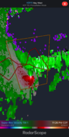
The flooding has already started in Miami. This was my college campus this afternoon after a 2 hour downpour; water was thigh deep on most roads around campus. Water was shooting through manhole covers throughout low lying areas as the sewers backed up. Wasn’t too out of the ordinary as these are occasional occurrences during thunderstorms, but will get worse over the next day as rain becomes more consistent and heavy. Will also be concerning if surge starts to compound the flooding. Predictions are only for one to two feet of saltwater inundation max here, but that could be enough to put the drainage system over the top during the most extreme downpours. Fortunately, Miami should definitely avoid the worst of the storm. However, if the surge and rainfall in Tampa become as bad as some predictions, they have a historic situation on their hands.If you want to see just how serious the rainfall with this thing is going to get. Just look at the current radar over Florida. Huge bands already rolling in from the interaction between Ian and the stalled front over central Florida. This trough is serious business and you can bet there’s going to be some big totals all along that from as it moves north.

Well, GFS's ultimate track gets Eastern AL involved with substantial rain this time.. and all of us, really.
Canadian looks to head to the big bend again, maybe a bit inland over northern FL
Yep better maps show that canadian is well east of it's last run.. id be getting out of tampa bay
iGRXY
Member
GFS all but just parks this thing over northern Georgia once inland.
Shaggy
Member
So we still have the 2 camps. One keeps it moving up along the east coast and the other slows or stalls over eastern gulf Tampa area
So we still have the 2 camps. One keeps it moving up along the east coast and the other slows or stalls over eastern gulf Tampa area
Yeh, the RGEM is east of 18z and shows a much more ominous track right into Tampa area while it's global bro skirts slightly west....
RGEM puts 36+ inches in Tampa.... so GFS is not alone
Tornadocane
Member
The flooding has already started in Miami. This was my college campus this afternoon after a 2 hour downpour; water was thigh deep on most roads around campus. Water was shooting through manhole covers throughout low lying areas as the sewers backed up. Wasn’t too out of the ordinary as these are occasional occurrences during thunderstorms, but will get worse over the next day as rain becomes more consistent and heavy. Will also be concerning if surge starts to compound the flooding. Predictions are only for one to two feet of saltwater inundation max here, but that could be enough to put the drainage system over the top during the most extreme downpours. Fortunately, Miami should definitely avoid the worst of the storm. However, if the surge and rainfall in Tampa become as bad as some predictions, they have a historic situation on their hands.View attachment 122225
I've had 4 inches of rain today in my gauge, and 2 inches within the last 3 hours. We might receive 8-12" totals, which is mind-boggling given our distance from the COC.
iGRXY
Member
GFS parks rain for about 72 hours here but somehow is spitting out 3-4” totals. They’ve got to do something about these feedback issues. It makes the model partially useless if you can’t even get accurate totals or surface reflectivity
I used to completely dismiss those insane amounts off hand thinking there’s no way they could verify, but after seeing them be right in Houston with Harvey and Wilmington with Florence, we know absolutely they can verifyYeh, the RGEM is east of 18z and shows a much more ominous track right into Tampa area while it's global bro skirts slightly west....
RGEM puts 36+ inches in Tampa.... so GFS is not alone
I used to completely dismiss those insane amounts off hand thinking there’s no way they could verify, but after seeing them be right in Houston with Harvey and Wilmington with Florence, we know absolutely they can verify
I am ashamed to admit that I did not watch/study Harvey very much. Did it have weak steering/got stuck too?
What I’m nervous about is most models have a period of intensification tomorrow past Cuba so aside from what’s happening tonight with the strength this thing will have a period of time to do something else once it’s past Cuba.
Yes almost nothing steering it but it sat for daysI am ashamed to admit that I did not watch/study Harvey very much. Did it have weak steering/got stuck too?
Yes… it stalled in a position right after landfall that just pumped a firehose right into Houston.I am ashamed to admit that I did not watch/study Harvey very much. Did it have weak steering/got stuck too?
iGRXY
Member
On average a tropical cyclone drops around 6-12” in a 12-24 hour period generally so to have one sit there for 36 hours and nearly put 4 feet of rain down over one area is absolutely astonishing
The 19 UTC NBM has an average below 9 inches for Tampa.. Lets hope that's what verifies, idk.. will have to see what it says after these 00z
Shaggy
Member
And the gefs spread opens at 90 hours. This is gonna be a tricky one. At 18z there was a strong cluster in the NE gom and none over water in the Atlantic hardly but now it's spread out and has a few more off the Florida east coast.
Attachments
Taylor C
Member
The rain totals on the GFS weren’t nice to Tampa, but at least the storm surge is lessened because the center is south.
Stormsfury
Member
Shaggy
Member
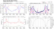
Movement looks due north tooI think that last pass RECON did has a sub 960mb pressure. That's a huge fall since the 965mb they pegged before that.
View attachment 122232
Taylor C
Member
Taylor C
Member
The HRRR, RAP, and 12KM NAM are way south and east.
Stormsfury
Member
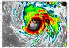
Yeah, Ian trying to go super Saiyan before the Cuba visit.
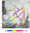
The eye has also shrunk 10 NM since the previous pass also.
778
URNT12 KNHC 270442
VORTEX DATA MESSAGE AL092022
A. 27/03:56:10Z
B. 21.38 deg N 083.66 deg W
C. 700 mb 2783 m
D. 961 mb
E. 305 deg 8 kt
F. CLOSED
G. C22
H. 97 kt
I. 185 deg 8 nm 03:53:30Z
J. 285 deg 91 kt
K. 187 deg 11 nm 03:52:30Z
L. 86 kt
M. 040 deg 18 nm 04:02:00Z
N. 135 deg 96 kt
O. 042 deg 22 nm 04:03:30Z
P. 10 C / 3048 m
Q. 17 C / 3042 m
R. 3 C / NA
S. 12345 / 07
T. 0.02 / 1 nm
U. AF301 1809A IAN OB 29
MAX FL WIND 96 KT 042 / 22 NM 04:03:30Z
;
Downeastnc
Member
Unsure Tampa, Florida, and the federal gov at large really have an idea of how catastrophic this is going to end up being
Possible Zone B will follow A with a mandatory if these solutions look likely tomorrow
brendan123
Member
The only thing that could really save Tampa from a historically destructive storm would be a landfall to the south and east that stops the worst of the surge from funneling into Tampa Bay, and even then the wind damage in the Tampa area would still likely be extensive. In any case, somewhere along the Florida Gulf Coast is likely to face one of the worst hurricanes for the state in recent memory.Unsure Tampa, Florida, and the federal gov at large really have an idea of how catastrophic this is going to end up being
Belle Lechat
Member
- Joined
- Aug 29, 2021
- Messages
- 1,529
- Reaction score
- 1,215
I grew up outside Houston with Alvin's 43 in in 24 hours in mind (Tropical Storm Claudette, July 1979). Out that way on the way to the beach after a good rain, one might see people jet skiing down the full ditches.I used to completely dismiss those insane amounts off hand thinking there’s no way they could verify, but after seeing them be right in Houston with Harvey and Wilmington with Florence, we know absolutely they can verify

Tropical Storm Claudette dumped more than 40 inches of rain in 1979
In 1979, Tropical Storm Claudette dumped 42 inches of rain in the Alvin area in just 24 hours. That record still stands 40 years later.
Not even Hurricane Harvey could top that rainfall production in one day. Harvey's highest 24-hour rainfall was 25.6 inches.
...
Clear Creek was a mile wide in some spots.

Alvin’s Deluge: It Reigns
Gulf Coast town holds U.S. record for greatest rainfall in 24 hours
They had no sense of what was to come, but their dogs must have. When the Klappers turned in for the evening, the dogs hid under their bed. At around 2 a.m., one of the dogs jumped up on the bed and woke Richard. He nudged it back down to the floor, but it didn’t land with the patter of paws; it landed with a splash. Richard turned on his bedside lamp and realized their entire bedroom was flooded.
Last edited:
Shaggy
Member
Euro is east by a decent bit already at 24 hours
Downeastnc
Member
Euro has center over Orlando in 70 hrs....
Shaggy
Member
Yeah once on land it hits the brakesEuro has center over Orlando in 70 hrs....
BHS1975
Member
The ukie may have a better handle on this due to weak steering. It's been rock steady thus far.
Sent from my iPhone using Tapatalk
Sent from my iPhone using Tapatalk
Shaggy
Member
EPS should be interesting
Belle Lechat
Member
- Joined
- Aug 29, 2021
- Messages
- 1,529
- Reaction score
- 1,215
CI# /Pressure/ Vmax
5.4 / 954mb / 100kts
Final T# Adj T# Raw T#
5.4 5.8 6.4
5.4 / 954mb / 100kts
Final T# Adj T# Raw T#
5.4 5.8 6.4
Downeastnc
Member
Center is about to cross onshore Cuba....

