Cary_Snow95
Member
Nc gets back in on the rain this run. Rains for about 40 hours across central nc
Gfs and cmcwould be big rain events for us. I'd argue they are probably too low on their qpf right now and not handling the strong moisture transport over top the residual CAD dome well.Nc gets back in on the rain this run. Rains for about 40 hours across central nc
Hard pass on rain with no wind. Need no mosquito maker right before deer season thank youGfs and cmcwould be big rain events for us. I'd argue they are probably too low on their qpf right now and not handling the strong moisture transport over top the residual CAD dome well.
A cadacane for the SE CAD regions. A preview of our cold rain winter ahead lol.50’s with an approaching hurricane moving inland. That’ll be something. Probably the coldest I’ve ever experienced a tropical storm/hurricane in this neck of the woods if it does verify.
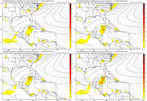
View attachment 121868
View attachment 121869
TruthA cadacane for the SE CAD regions. A preview of our cold rain winter ahead lol.
Agree with Shane. Euro will be interesting for sure. Stay the path or adjust. Usually lean euro, but not always. If it stays the same I will probably lean that way too. This isn’t a trof trying to come down in July or August. It’s almost October
Hasn't this happened before? At least in NC50’s with an approaching hurricane moving inland. That’ll be something. Probably the coldest I’ve ever experienced a tropical storm/hurricane in this neck of the woods if it does verify.
View attachment 121868
View attachment 121869
Better check Hazel: I had ole timers tell me over in western NC it was very cool.Hasn't this happened before? At least in NC
Sent from my LM-Q730 using Tapatalk


This could end up as as LA hit, or even more west! These wild run to run swings just mean there are a lot of tiny variables, that can lead to major changes, if the trough misses it, anything in the gulf is possible, IMOGoing to be interesting to see if the Euro agrees with the cmc and gfs on kicking the trough out and collapsing the steering so this really slows down west of FL and has to wait for the WAR to flex or something to the west to kick it. It's crazy that the cmc and gfs are almost on top of each other even at 192 hours
LoL still have child trauma from that storm. I could def see it happening. Irma was pretty bad here too . Newnan still recovering from the big tornado."Way down yonder on the Chattahoochee". OPAL is that you coming Back?
It was very cool after Hugo. Like a few days later, highs in the 50s and rain. Can’t remember what it was like as it was occurringBetter check Hazel: I had ole timers tell me over in western NC it was very cool.
Irma did that a few years ago, I believe. We lost power and lit a fire in the fireplace for heat and light. Temps in the 50's with a howling northeast wind. That was 9/12/2017.50’s with an approaching hurricane moving inland. That’ll be something. Probably the coldest I’ve ever experienced a tropical storm/hurricane in this neck of the woods if it does verify.
View attachment 121868
View attachment 121869
Idk but as of right now, they’re definitely in the cone. Sounds like this guy in a dumbassDoesn't that guy realize that it's forecast to be a major at landfall?
Sent from my LM-Q730 using Tapatalk
After reading the rest of the comments, he goes on to say unless the center is supposed to come over the Cape, then they won’t roll it back in the bay. Also says he’s not from Florida but DC so take that for what it’s worthwhat was the question? sounds pretty dismissive on the surface
Not down here in the Charleston area after Hugo. In the 90s for several days until a cool down a little later. 2 weeks later, there was a small regional severe outbreak. A tornado hit in Goose Creek and wiped out a mobile home that survived Hugo.It was very cool after Hugo. Like a few days later, highs in the 50s and rain. Can’t remember what it was like as it was occurring
Yes, my mistake! I was in Gastonia. I remember it being cold and rainy at some point and still being without power, it could of been a week after! ??Not down here in the Charleston area after Hugo. In the 90s for several days until a cool down a little later. 2 weeks later, there was a small regional severe outbreak. A tornado hit in Goose Creek and wiped out a mobile home that survived Hugo.
