NEGaweather
Member
Don’t think over seen a tropical storm watch for commerce ga
Sent from my iPhone using Tapatalk
Sent from my iPhone using Tapatalk
IM in the panhandle. about 10 miles from PCBAre you in south Georgia? I'm in 70% area just south of Atlanta.
I'm just a short ways south of you, and we can definitely be hit with some high wind gusts and upslope rains depending on the exact orientation of the wind.Even if these wind gust projections are overdone, it's gonna be quite noisy due to the pressure gradients
I'm really interested to see what inland areas are going to see the biggest impact. I'm in the Holly Springs area, kind of on the edge of the foothills. On the other hand, my family will be visiting Sapphire NC tomorrow thru Sunday. I can imagine it'll be quite breezy being on the Escarpment. But that pressure battle zone as the storm gets eaten by the ULL will be really interesting to observe.

And this is lock step with the latest GFS. This would not be good for a lot of folks as that much rain and wind in the mountains and foothills would cause a lot of havoc.12z ICON landfall at 940 and goes EAST track.
Pressure aligned with HWRF and HMON.
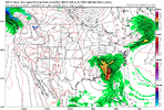
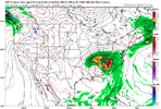
View attachment 151775


This has to be at least 75 miles east of the official forecast track. I'm not even sure what to believe. Some models show it east and the official track has it west.And this is lock step with the latest GFS. This would not be good for a lot of folks as that much rain and wind in the mountains and foothills would cause a lot of havoc.
View attachment 151778
View attachment 151779
Yea makes no sense, not wishcasting at all but these models showing it going that far east and the NHS keeps bumping it west lolThis has to be at least 75 miles east of the official forecast track. I'm not even sure what to believe. Some models show it east and the official track has it west.
We'll see if climo wins in the end or not. That was a nws map, not mine. They know way more than any of us.This storm is not climo. As mentioned by many mets, this is likely going to be far different inland.
I mean we are like 36 hours from landfall. There shouldn't be these huge differences in forecast track.Yea makes no sense, not wishcasting at all but these models showing it going that far east and the NHS keeps bumping it west lol
Landfall doesn’t seem to change its just the path once inlandI mean we are like 36 hours from landfall. There shouldn't be these huge differences in forecast track.
Man if you think about the forest areas up there, this has the potential to completely change the landscape over a wide area. Long lasting effects.I'm just a short ways south of you, and we can definitely be hit with some high wind gusts and upslope rains depending on the exact orientation of the wind.
View attachment 151777
It really has nothing to do with the Yucatan. Look at the ULL to the west and the Atlantic ridge to the east...thats where you will see your differences that are influencing the outcome.On thing I noticed is that the models that swing Helene closer to the Yucatan end up being on the western side of guidance whereas the ones that stay farther away end up on the eastern half. Ex. the HMON clipped the Yucatan and ended in west GA, whereas the HWRF stayed farther off the coast and remained farther east till the US where is ended up in central and NE GA opposed to west and NW GA. Maybe something to keep an eye on. The latest center find from recon has the center pinged farther from the Yucatan. I wonder if that will have any effects downstream like the models suggest or if its just a coincidence.
i disagree, i think the storm getting tangled with land interaction is what put weaker solutions on the table and supported western solutions. ensemble data showed stronger solutions favoring the eastern side of the envelope. i wouldn't be surprised to seem some eastward ticks in modeling this cycle now that that hurdle has been clearedIt really has nothing to do with the Yucatan. Look at the ULL to the west and the Atlantic ridge to the east...thats where you will see your differences that are influencing the outcome.
