Ser Pounce
Member
Calm and rainy just off the Ashley River, across and up just a bit from The Citadel.
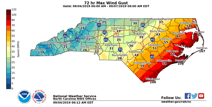
Check with your local National Weather Service. They are putting out some great graphics showing winds, precip, and timing. Here's an example for NC (Raleigh office):I saw some saying that the Euro tends to have strong winds too far inland but I see quite a few models showing around the same solution. Are most models overdoing this?
SUMMARY OF 1000 AM EDT...1400 UTC...INFORMATION
----------------------------------------------
LOCATION...29.7N 79.6W
ABOUT 90 MI...145 KM ENE OF DAYTONA BEACH FLORIDA
ABOUT 130 MI...210 KM ESE OF JACKSONVILLE FLORIDA
MAXIMUM SUSTAINED WINDS...105 MPH...165 KM/H
PRESENT MOVEMENT...NNW OR 330 DEGREES AT 8 MPH...13 KM/H
MINIMUM CENTRAL PRESSURE...964 MB...28.47 INCHES
I saw some saying that the Euro tends to have strong winds too far inland but I see quite a few models showing around the same solution. Are most models overdoing this?
06z HWRF looked the same....
80w is key
Closer to coast I think we get a more pronounced west turn soon12Z NAM is no bueno for Charleston and points north. Even brings it in NC west of OBX.
Looks like it might not make 80w. If it doesn’t get to that or just west I think it has a good chance to be off the coast.
Looking like as Dorian approached the 80W line, she pulled back East on the last few frames.
Agreed although we need to make sure it doesn’t wobble too much to the left. But no doubt that in addition to feeling much better for here, if I were living in CHS I’d be much less worried than I was when that 18Z Euro came out. The 10 AM position is the same as it has been for 2 hours, 79.6 W. The longitude of CHS is at 79.9 W. I’m not saying he won’t have one last period of some more west component of motion (if so most likely during a wobble) but he clearly has been struggling to have much west component of motion for the last few hours. All models suggest his longitude as he gets close to SC will be a fair amount east of what it is when it is due east of the FL/GA line. So, the key in my mind for CHS is his longitude once east of the FL/GA border. If it is only west to about 79.9 then, I wouldn’t see CHS getting that bad of a hit. And then IF he is only around, say, 79.7 then, that would be even better news for CHS and probably even a bit further up the SC coast.
I thought the western side was the good side of the storm ? At least thats what James Spann always says.Jim Cantore had made an interesting point yesterday.. the sun can help these heavier winds mix down to the surface between bands sometimes. For future reference. The western side of the storm is expected to be far reaching and nasty.
I thought the western side was the good side of the storm ? At least thats what James Spann always says.
I am going to trust Levi and a plethora of other mets saying the West side of this storm will become more expansive and nasty. I'm not sure of all the intricate on a forecasting level.
Here is the satellite data I'm using where you can clearly see the East jog away from 80w on the last few frames. I like to do at least 48 frames worth to get a good idea: https://weather.cod.edu/satrad/?par...1-100-1&checked=latlon-map&colorbar=undefined
I am going to trust Levi and a plethora of other mets saying the West side of this storm will become more expansive and nasty. I'm not sure of all the intricate on a forecasting level.
")
The 3K NAM was quite a jog farther west at landfall in NC than even the 6z. 10m winds jumped considerably over the Triangle, as did rainfall.Not sure for further south but in NC the storm will be closer to the front and there will be dryer air working in the west side, there will also be a lot of heavier precip, this all helps bring the 925mb level winds ( which are already closer to the surface due to strong SLP ) to the surface more efficiently....the 925MB wind field on the NW side of the storm will be 60-90knts over NC so 70-100 MPH. I am sure the term sting jet will get abused the next 36 hrs as well

SUMMARY OF 1100 AM EDT...1500 UTC...INFORMATION
-----------------------------------------------
LOCATION...29.8N 79.7W
ABOUT 90 MI...140 KM ENE OF DAYTONA BEACH FLORIDA
ABOUT 205 MI...335 KM S OF CHARLESTON SOUTH CAROLINA
MAXIMUM SUSTAINED WINDS...105 MPH...165 KM/H
PRESENT MOVEMENT...NNW OR 335 DEGREES AT 9 MPH...15 KM/H
MINIMUM CENTRAL PRESSURE...964 MB...28.47 INCHES
The 3K NAM was quite a jog farther west at landfall in NC than even the 6z. 10m winds jumped considerably over the Triangle, as did rainfall.

All indications are that this 12Z NAM will very likely end up verifying as too far west there.
Wait, is he back now?Latest from Greg Fishel.
RECON REPORTS DON’T SHOW STRENGTHENING YET BUT ON SATELLITE IMAGERY DEEP CONVECTION IS BEGINNING TO WRAP AROUND A SMALLER AREA NEAR THE CENTER OF CIRCULATION. THIS COULD BE A SIGN OF FUTURE INTENSIFICATION OF DORIAN. WATCHING CAREFULLY!


