They haven't seeded it yet. They need to get that going. Or get ready to launch the Trident.What ERC's? This storm likes its eyewall too much to lose it.
-
Hello, please take a minute to check out our awesome content, contributed by the wonderful members of our community. We hope you'll add your own thoughts and opinions by making a free account!
You are using an out of date browser. It may not display this or other websites correctly.
You should upgrade or use an alternative browser.
You should upgrade or use an alternative browser.
Tropical Hurricane Dorian
- Thread starter RBR71
- Start date
NBAcentel
Member
Dorian getting that look that a ERC May begin soon
ICON stalls then NNW movement starting at H42.
The funny thing about the Euro (I have not verified this personally, but it came from a met on social media), it has supposedly performed the absolute worst of all modeling in regards to strength of Dorian so far.
I saw that too. But I don't know how that's being measured.The funny thing about the Euro (I have not verified this personally, but it came from a met on social media), it has supposedly performed the absolute worst of all modeling in regards to strength of Dorian so far.
Dorian getting that look that a ERC May begin soon
Sent from my SM-G950U using Tapatalk
I remember all of the “50 mile” talk with Mathew and it just stayed offshore. I’m not sure Dorian even gets as close to the coast as Mathew. I’m ever so slightly concerned that a LF might be possible up towards Hatteras though. Just a half a percentage point. An outside chance. But possible. Very scary what’s going on in the Bahamas right now. I just can’t imagineI know there are varying opinions on this, but I feel like the Euro has done a relatively good job with the overall track idea. I know it has oscillated around with the exact track, but it has been fairly consistent showing the recurve...i.e. not sending it underneath FL like the Icon was or into the Gulf like the UK (i mean i think it did initially, but it's been off that idea for a while), or sending it well inland like the Canadian was doing. Assuming the track remains offshore and the recurve happens, I think it will have done pretty well. Initially, it had the wrong idea, but it's been pretty similar now for a while.
We're in a situation where 50 miles can make a huge difference, especially with regard to landfall/no landfall. But I have a hard time being too critical of a model for failing to get to that degree of specificity 3+ days out for a Cat 5 hurricane.
IDK, it still looks very healthy eye wall. It very well may start an ERC, recon will help with that in a bit.
Downeastnc
Member
Dorian getting that look that a ERC May begin soon
yeah surprisingly it does seem to be starting into a ERC.....good news for the Bahamas's sorta.....bad news is the wind field will expand.....
I will say this, if that Atlantic ridge starts building back in quicker (models, especially euro) are hinting at that, Plus the trof over the GL and NE is trending quicker and further north, I **could** see this coming up and trying to sneak into NE FL and north then NE and just pound all states in the SE. Euro op and especially the EPS are a little messy again, and that tells me there might be some funny changes going forward.
They’ve got to seed it after rapid intensification. Although they will most likely hold off now since it’s predicted to stay offshore. If they seed it at the wrong time they trade isolated Wind/High Surf disaster for Widespread flood disaster which is much more costly to the big banks and insurance companies.They haven't seeded it yet. They need to get that going. Or get ready to launch the Trident.
Don’t shoot the messenger
pcbjr
Member
Chris ... I haven't written off the Space Coast just yet ...I will say this, if that Atlantic ridge starts building back in quicker (models, especially euro) are hinting at that, Plus the trof over the GL and NE is trending quicker and further north, I **could** see this coming up and trying to sneak into NE FL and north then NE and just pound all states in the SE. Euro op and especially the EPS are a little messy again, and that tells me there might be some funny changes going forward.
Phil,
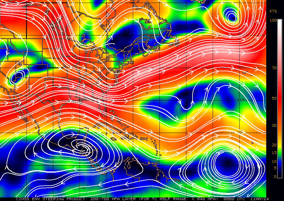
Thanks for posting this updated. Like the map you posted earlier, it would be better to post the steering for under 940 mb. This one is for 1000-1010 mb.
Downeastnc
Member
IDK, it still looks very healthy eye wall. It very well may start an ERC, recon will help with that in a bit.
NHC thinks maybe it is but could be a fake out maybe a little bit of tightening from land interaction might not be a true ERC, the core looks pretty healthy to me....
From 5pm NHC disco
The eye has been shrinking, and an eyewall replacement cycle is
possibly occurring. The effect of the island terrain and the
eyewall replacement cycle should result in some slight fluctuations
in intensity during the next 24 to 36 hours, but the hurricane will
continue to be extremely dangerous one during that time.
Henry2326
Member
I agree with some of what you said....but....it only became a cat5 this morning around 9:00 and it was barely forecasted on HWRF.. I agree with Phil, the models are trying to apply knowns to a situation full of unknowns. The saying goes "you only know what you know." I'm worried about what we don't know.....I know there are varying opinions on this, but I feel like the Euro has done a relatively good job with the overall track idea. I know it has oscillated around with the exact track, but it has been fairly consistent showing the recurve...i.e. not sending it underneath FL like the Icon was or into the Gulf like the UK (i mean i think it did initially, but it's been off that idea for a while), or sending it well inland like the Canadian was doing. Assuming the track remains offshore and the recurve happens, I think it will have done pretty well. Initially, it had the wrong idea, but it's been pretty similar now for a while.
We're in a situation where 50 miles can make a huge difference, especially with regard to landfall/no landfall. But I have a hard time being too critical of a model for failing to get to that degree of specificity 3+ days out for a Cat 5 hurricane.
pcbjr
Member
Phil,
Thanks for posting this updated. Like the map you posted earlier, it would be better to post the steering for under 940 mb. This one is for 1000-1010 mb.
Henry2326
Member
Imagine the surge into the bay....18z ICON is SW of 12z
View attachment 22792
This?Phil,
Thanks for posting this updated. Like the map you posted earlier, it would be better to post the steering for under 940 mb. This one is for 1000-1010 mb.
Henry2326
Member
I haven't written off any option that has been presented...Chris ... I haven't written off the Space Coast just yet ...
pcbjr
Member
Yup and I'm confusedThis?

gawxnative
Member
I keep getting this "nagging/gut feeling" that Dorian may be what Floyd was feared to be ..No offense to what NC when through with him.
pcbjr
Member
Larry - Says 200 - 700 <940 ... what am I missing?Phil,
Thanks for posting this updated. Like the map you posted earlier, it would be better to post the steering for under 940 mb. This one is for 1000-1010 mb.
That is the correct one since our hurricane is so strong. Different steering level vs the one you had posted before.Yup and I'm confused
pcbjr
Member
Thanks!That is the correct one since our hurricane is so strong. Different steering level vs the one you had posted before.
This?

One can see here that the westerly steering is starting to weaken/collapse as the high weakens and the trough to the north passes by. So, we have to make sure that the semi-stall happens by about the western edge of Grand Bahama island by tomorrow evening. If so, FL should avoid a landfall.
I think right now I would blend the 12z Euro with Hurricane Mathew and Hurricane Floyd and that’s your track
ForsythSnow
Moderator
Southern Florida should. The Northern part can still be impacted as demonstrated by the HWRF. Of course it never fully stops, but it slows considerably enough to turn.One can see here that the westerly steering is starting to weaken/collapse as the high weakens and the trough to the north passes by. So, we have to make sure that the semi-stall happens by about the western edge of Grand Bahama island by tomorrow evening. If so, FL should avoid a landfall.
packfan98
Moderator
18z GFS looks to be a slight tick further west compared to 12z out to hour 33. Maybe 10 miles? Every mile counts on this one when it comes to sensible weather over land.
pcbjr
Member
We're all giving it our best shot ... somewhere in here is the "answer" ... likely not mine but as we all are ... tryin' ... 
Edit: and we all bring a bunch of knowledge, experience, differing perspectives, and a good bit of gut to the table ... carry on ...
Edit: and we all bring a bunch of knowledge, experience, differing perspectives, and a good bit of gut to the table ... carry on ...
packfan98
Moderator
18z looks very similar to the ICON through hour 60. It's definitely closer to the coastline than 12z.
18Z GFS center
Only 50 miles offshore Daytona paralleling the coast.
18z looks very similar to the ICON through hour 60. It's definitely closer to the coastline than 12z.
Only 50 miles offshore Daytona paralleling the coast.
packfan98
Moderator
Yes. I would think that hurricane conditions would be met on the immediate coastline of N FL and GA at hr 69.18Z GFS center
Only 50 miles offshore Daytona paralleling the coast.
Definitely west on the 18z GFS
GFS-Legacy also a bit southwest
GeorgiaGirl
Member
Seems like a Wilmington landfall here on the GFS.
Still fairly strong as well although not as strong as it is today (obvious).
Still fairly strong as well although not as strong as it is today (obvious).
dsaur
Member
If one got big enough in conjuntion with an earth quake to break up the methane hydrates, with all that lightening, ........oh, the humanity for sure. Burning hurricane sharknado. I'm going to write the script right now...as soon as I don't wash the car againNo it would just become burning Godzilla


