-
Hello, please take a minute to check out our awesome content, contributed by the wonderful members of our community. We hope you'll add your own thoughts and opinions by making a free account!
You are using an out of date browser. It may not display this or other websites correctly.
You should upgrade or use an alternative browser.
You should upgrade or use an alternative browser.
Tropical Hurricane Dorian
- Thread starter RBR71
- Start date


Webberweather53
Meteorologist
I'm somewhat doubtful of that solution at this juncture, Dorian would really have to take a hard left here for several hours to take the circulation over the island but frictional convergence & channeling w/ the terrain of PR could tug it in that direction once Dorian reaches the latitude of PR
No kidding, just looking at radar unless it starts to feel that tug it's going NE of PR..... dangI'm somewhat doubtful of that solution at this juncture, Dorian would really have to take a hard left here for several hours to take the circulation over the island but frictional convergence & channeling w/ the terrain of PR could tug it in that direction once Dorian reaches the latitude of PR
I'm somewhat doubtful of that solution at this juncture, Dorian would really have to take a hard left here for several hours to take the circulation over the island but frictional convergence & channeling w/ the terrain of PR could tug it in that direction once Dorian reaches the latitude of PR
Thats what I thought to when looking at the radar.
B
Brick Tamland
Guest
Well, the overnight runs didn't clear anything up as far as where Dorian will go, but they do pretty much agree this could become a major hurricane in the next few days. GFS the furthest north, while others have it hitting Florida still. I see the GFS went from hitting NC to further south into SC the last run, though, so maybe it is adjusting further south in line with the other models showing Dorian going into Florida.
It could turn west into PR but right now it's heading for St. Thomas or between that and PR, either way what is this nearly 300 miles east of yesterday's projections? Holy smokes..Thats what I thought to when looking at the radar.
https://radar.weather.gov/radar.php?rid=JUA&product=N0Z&overlay=11101111&loop=yes
B
Brick Tamland
Guest
I wish we still had the live thread option.
Webberweather53
Meteorologist
I think it's safe to say Dorian has achieved "megachonker" status.
.jpg")
Snowflowxxl
Member
Galaxy’s Edge is opening up this weekend in Orlando. This sucks for that!
Last edited:
Tight cluster around the space coast of Fl

Henry2326
Member
Actually I see-
3 to mid FL
1 to lower FL
2 to SC
1 to Jax
1 to OTS
2 north to NC
Median- black line.... no landfall yet...might curve
I can't imagine any more uncertainty....

Shaggy
Member
Skeptical of any model being right at this point because they missed so badly in the short term. 3 days ago this was going over the shredder or shooting the gap between PR and hispaniola and now it stands a real chance of missing PR east. This is a pretty big bust in the short range.
Ethan80963!
Member


Henry2326
Member
I agree....a business miss their forecast in this short of term and somebody getting fired. Especially when some of it was driven by placing the current position in the wrong spot on the map.Skeptical of any model being right at this point because they missed so badly in the short term. 3 days ago this was going over the shredder or shooting the gap between PR and hispaniola and now it stands a real chance of missing PR east. This is a pretty big bust in the short range.
Ethan80963!
Member
Here's the latest pass from recon

Henry2326
Member
Navgem 06z in the middle of the curve north and tremendously stronger.....that is new! It followed Euro at 00z.....
Snow_chaser
Member
Totally off topic and I apologize, but I wanted to take a minute to thank you guys for all this amazing info you share. The analysis and info y’all share is so appreciated, Thank You for sharing your knowledge with us all.
thank you to everyone for all of the hard work and your expertise is much appreciated
Ethan80963!
Member
Almost looks like an eye on the Puerto Rico radar
https://radar.weather.gov/radar.php?product=N0R&rid=JUA&loop=yes
https://radar.weather.gov/radar.php?product=N0R&rid=JUA&loop=yes
Webberweather53
Meteorologist
Almost looks like an eye on the Puerto Rico radar
https://radar.weather.gov/radar.php?product=N0R&rid=JUA&loop=yes
It definitely is one, at least in the primitive sense. Recent dropsondes by recon show that the air is drying right at Dorian's center which means the eye is progressively clearing out.
Webberweather53
Meteorologist
New dropsonde in the eye suggests minimum central pressure is around 1000 hPa after accounting for the near 20 knots of sfc wind.

She may already be a hurricane or at least very close to it.
Product: Air Force Vortex Message (URNT12 KNHC)
Transmitted: 28th day of the month at 13:37Z
Agency: United States Air Force
Aircraft: Lockheed WC-130J Hercules with reg. number AF99-5309
Storm Number & Year: 05 in 2019
Storm Name: Dorian (flight in the North Atlantic basin)
Mission Number: 9
Observation Number: 09
A. Time of Center Fix: 28th day of the month at 13:00:00Z
B. Center Fix Coordinates: 17.33N 64.18W
B. Center Fix Location: 145 statute miles (233 km) to the ESE (121°) from San Juan, Puerto Rico (U.S.).
C. Minimum Height at Standard Level: 1,445m (4,741ft) at 850mb
D. Minimum Sea Level Pressure: 1002mb (29.59 inHg)
E. Dropsonde Surface Wind at Center: From 345° at 18kts (From the NNW at 21mph)
F. Eye Character: Open in the northwest
G. Eye Shape & Diameter: Circular with a diameter of 18 nautical miles (21 statute miles)
H. Estimated (by SFMR or visually) Maximum Surface Wind Inbound: 32kts (36.8mph)
I. Location & Time of the Estimated Maximum Surface Wind Inbound: 29 nautical miles (33 statute miles) to the WNW (298°) of center fix at 12:49:30Z
J. Maximum Flight Level Wind Inbound: From 15° at 34kts (From the NNE at 39.1mph)
K. Location & Time of the Maximum Flight Level Wind Inbound: 10 nautical miles (12 statute miles) to the W (272°) of center fix at 12:56:00Z
L. Estimated (by SFMR or visually) Maximum Surface Wind Outbound: 51kts (58.7mph)
M. Location & Time of the Estimated Maximum Surface Wind Outbound: 8 nautical miles to the ESE (117°) of center fix at 13:04:00Z
N. Maximum Flight Level Wind Outbound: From 213° at 56kts (From the SSW at 64.4mph)
O. Location & Time of the Maximum Flight Level Wind Outbound: 10 nautical miles (12 statute miles) to the ESE (120°) of center fix at 13:04:30Z
P. Maximum Flight Level Temp & Pressure Altitude Outside Eye: 16°C (61°F) at a pressure alt. of 1,522m (4,993ft)
Q. Maximum Flight Level Temp & Pressure Altitude Inside Eye: 20°C (68°F) at a pressure alt. of 1,527m (5,010ft)
R. Dewpoint Temp (collected at same location as temp inside eye): 16°C (61°F)
R. Sea Surface Temp (collected at same location as temp inside eye): Not Available
S. Fix Determined By: Penetration, Radar, Wind, Pressure and Temperature
S. Fix Level: 850mb
T. Navigational Fix Accuracy: 0.02 nautical miles
T. Meteorological Accuracy: 0.05 nautical miles
Remarks Section:
Maximum Flight Level Wind: 72kts (~ 82.9mph) which was observed 12 nautical miles (14 statute miles) to the NE (45°) from the flight level center at 11:46:30Z
General Note About Vortex Messages:
- Reported winds are usually averaged over a 10 second period. (The National Hurricane Center's advisory wind speeds are the highest expected winds averaged over a 1 minute period.)
One thing I’ve noticed through the years is don’t be surprised to see a WSW or SW motion as the ridge builds back north of the system.
Ethan80963!
Member
Almost 2 days ahead of scheduleShe may already be a hurricane or at least very close to it.
Product: Air Force Vortex Message (URNT12 KNHC)
Transmitted: 28th day of the month at 13:37Z
Agency: United States Air Force
Aircraft: Lockheed WC-130J Hercules with reg. number AF99-5309
Storm Number & Year: 05 in 2019
Storm Name: Dorian (flight in the North Atlantic basin)
Mission Number: 9
Observation Number: 09
A. Time of Center Fix: 28th day of the month at 13:00:00Z
B. Center Fix Coordinates: 17.33N 64.18W
B. Center Fix Location: 145 statute miles (233 km) to the ESE (121°) from San Juan, Puerto Rico (U.S.).
C. Minimum Height at Standard Level: 1,445m (4,741ft) at 850mb
D. Minimum Sea Level Pressure: 1002mb (29.59 inHg)
E. Dropsonde Surface Wind at Center: From 345° at 18kts (From the NNW at 21mph)
F. Eye Character: Open in the northwest
G. Eye Shape & Diameter: Circular with a diameter of 18 nautical miles (21 statute miles)
H. Estimated (by SFMR or visually) Maximum Surface Wind Inbound: 32kts (36.8mph)
I. Location & Time of the Estimated Maximum Surface Wind Inbound: 29 nautical miles (33 statute miles) to the WNW (298°) of center fix at 12:49:30Z
J. Maximum Flight Level Wind Inbound: From 15° at 34kts (From the NNE at 39.1mph)
K. Location & Time of the Maximum Flight Level Wind Inbound: 10 nautical miles (12 statute miles) to the W (272°) of center fix at 12:56:00Z
L. Estimated (by SFMR or visually) Maximum Surface Wind Outbound: 51kts (58.7mph)
M. Location & Time of the Estimated Maximum Surface Wind Outbound: 8 nautical miles to the ESE (117°) of center fix at 13:04:00Z
N. Maximum Flight Level Wind Outbound: From 213° at 56kts (From the SSW at 64.4mph)
O. Location & Time of the Maximum Flight Level Wind Outbound: 10 nautical miles (12 statute miles) to the ESE (120°) of center fix at 13:04:30Z
P. Maximum Flight Level Temp & Pressure Altitude Outside Eye: 16°C (61°F) at a pressure alt. of 1,522m (4,993ft)
Q. Maximum Flight Level Temp & Pressure Altitude Inside Eye: 20°C (68°F) at a pressure alt. of 1,527m (5,010ft)
R. Dewpoint Temp (collected at same location as temp inside eye): 16°C (61°F)
R. Sea Surface Temp (collected at same location as temp inside eye): Not Available
S. Fix Determined By: Penetration, Radar, Wind, Pressure and Temperature
S. Fix Level: 850mb
T. Navigational Fix Accuracy: 0.02 nautical miles
T. Meteorological Accuracy: 0.05 nautical miles
Remarks Section:
Maximum Flight Level Wind: 72kts (~ 82.9mph) which was observed 12 nautical miles (14 statute miles) to the NE (45°) from the flight level center at 11:46:30Z
General Note About Vortex Messages:
- Reported winds are usually averaged over a 10 second period. (The National Hurricane Center's advisory wind speeds are the highest expected winds averaged over a 1 minute period.)
AL, 05, 2019082812, 03, OFCL, 3, 175N, 645W, 60, 1000, TS
Latest recon is showing hurricane force winds.141530 1809N 06352W 8429 01605 0156 +158 +158 134042 045 040 013 03
141600 1807N 06353W 8430 01604 0164 +156 +156 135047 051 042 019 00
141630 1806N 06354W 8425 01606 0161 +156 +156 126034 043 041 018 03
141700 1805N 06355W 8433 01597 0162 +153 +153 118033 035 040 016 03
141730 1803N 06356W 8416 01612 0157 +153 //// 118034 036 040 028 05
141800 1802N 06357W 8433 01595 0142 +160 //// 127038 040 035 006 01
141830 1801N 06358W 8429 01598 0141 +162 //// 132044 045 036 005 05
141900 1759N 06359W 8432 01593 0133 +164 //// 132047 048 037 006 01
141930 1758N 06400W 8435 01584 0139 +162 //// 132046 048 037 007 05
142000 1757N 06400W 8433 01584 0139 +161 +161 140047 049 039 008 00
142030 1756N 06401W 8428 01586 0128 +161 //// 143051 052 039 007 05
142100 1755N 06402W 8433 01579 0138 +155 +155 143051 053 038 008 03
142130 1753N 06403W 8429 01583 0139 +160 +160 150049 051 045 041 03
142200 1752N 06404W 8416 01590 0139 +155 +155 152056 057 058 027 00
142230 1751N 06405W 8436 01572 0140 +153 +153 144054 057 046 024 03
142300 1750N 06406W 8434 01571 0131 +159 +159 143052 054 038 010 03
142330 1749N 06406W 8438 01566 0123 +163 +163 149055 057 039 007 00
142400 1748N 06407W 8427 01574 0124 +159 +159 150054 055 040 009 03
142430 1746N 06408W 8436 01562 0119 +156 +156 149060 062 /// /// 03
142500 1745N 06409W 8432 01562 0119 +151 +151 151065 065 047 008 03
Ethan80963!
Member
Next NHC intensity update and cone placement will be interesting for sure
ForsythSnow
Moderator
Those are flight level winds. Don't let that fool you. The one to the right of that is surface. Also note the 03 at the far right. That means it's flagged. look for 00 for unflagged accurate readings.Latest recon is showing hurricane force winds.
B
Brick Tamland
Guest
NHC Director Ken Graham and, for our Spanish-language viewers, TAFB meteorologist Maria Torres will provide a Facebook Live broadcast at 11:30 a.m. AST/EDT regarding Tropical Storm Dorian.
Yep.Am I reading this correct? Does that mean that the 11 AM advisory will be 60 Kts and 1000 MSP?
ForsythSnow
Moderator
A very clear indication of a developing eyewall on the latest pass. Look how the winds sharply drop with the pressure. I thin it'll be a hurricane at the 2 pm advisory. Too early to call it one now, but he's on his way to becoming one with just a little more structure.

075
URNT15 KNHC 281435
AF309 0905A DORIAN HDOB 31 20190828
142530 1744N 06410W 8426 01558 0111 +153 +153 153064 065 052 014 03
142600 1743N 06410W 8433 01548 0104 +158 +158 160064 065 053 014 03
142630 1742N 06411W 8428 01549 0098 +161 +161 162065 066 057 013 03
142700 1741N 06412W 8430 01539 0088 +164 +164 168066 067 /// /// 03
142730 1740N 06413W 8430 01536 0074 +175 +175 180060 066 059 012 03
142800 1739N 06413W 8433 01536 0069 +180 //// 189055 059 058 009 05
142830 1739N 06415W 8423 01537 0057 +177 //// 191041 052 060 002 05
142900 1739N 06417W 8440 01520 //// +176 //// 192032 039 049 002 01
142930 1739N 06418W 8420 01536 //// +179 //// 191026 030 039 003 01
143000 1739N 06420W 8442 01509 //// +182 //// 192018 022 029 001 01
143030 1739N 06422W 8431 01521 0029 +187 +181 203014 015 026 002 01
143100 1740N 06423W 8440 01513 0026 +195 +175 215010 014 024 002 00
143130 1741N 06425W 8474 01475 0025 +195 +175 177008 009 025 000 00
143200 1742N 06426W 8440 01509 0022 +198 +173 118005 007 026 001 03
143230 1742N 06428W 8442 01506 0025 +195 +177 059008 011 024 005 00
143300 1743N 06429W 8478 01477 0029 +197 +180 038011 013 027 003 03
143330 1743N 06431W 8483 01472 0029 +200 +182 358016 020 040 005 03
143400 1741N 06432W 8432 01531 0044 +183 +177 328023 025 040 005 00
143430 1740N 06433W 8433 01530 0064 +175 //// 319026 028 038 006 01
143500 1739N 06434W 8433 01538 0069 +167 //// 319028 031 037 005 01
Latest recon pass has the SFMR winds near hurricane strength.
Lot more pink barbs this time

Webberweather53
Meteorologist
Dorian isn't even gonna come close to Puerto Rico at this rate. This is a pretty colossal short-range forecast bust
That's not good.Dorian isn't even gonna come close to Puerto Rico at this rate.
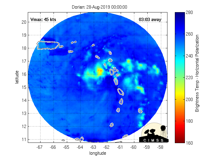
ForsythSnow
Moderator
The microwave imagery definitely shows how the strength is inside the storm. You can see the strong north half of the eyewall developing but there is much work for the southern half. It's getting there though.
Henry2326
Member
Doesn't bode well for a longer term eitherDorian isn't even gonna come close to Puerto Rico at this rate. This is a pretty colossal short-range forecast bust
Webberweather53
Meteorologist
Dorian's eyewall looks like it's closed off now on radar. That's not good...