pcbjr
Member
Regardless, I do not like it Sam I said, I do not like its green eggs and ham ...It's the IBM model that is using the core that the National Weather Service chose not to go with when they chose the FV3.
Regardless, I do not like it Sam I said, I do not like its green eggs and ham ...It's the IBM model that is using the core that the National Weather Service chose not to go with when they chose the FV3.

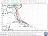
Every model offshore but I there's an issue imo, every model has this making that NW turn just prior to 75W..... it's crossed 75 still moving west.
View attachment 22669


What in the wide, wide world of sports is the MPAS model?? We might as well see what the Pioneer shows.
Not a Cat 5 yet.SUMMARY OF 1100 PM EDT...0300 UTC...INFORMATION
-----------------------------------------------
LOCATION...26.3N 75.1W
ABOUT 125 MI...200 KM E OF GREAT ABACO ISLAND
ABOUT 310 MI...500 KM E OF WEST PALM BEACH FLORIDA
MAXIMUM SUSTAINED WINDS...150 MPH...240 KM/H
PRESENT MOVEMENT...W OR 280 DEGREES AT 8 MPH...13 KM/H
MINIMUM CENTRAL PRESSURE...940 MB...27.76 INCHES
.gif")
Chris,
Nothing ... question is, what is missing ...Am I the only one
This does look scary since it shows the steering current to the west would need to collapse in a timely manner to recurve in time. However, it looks like to me that even the Euro just had it crossing 75W this evening moving just N of W and, therefore, he is matching up well with the Euro. Am I about the only not overly concerned at this point about any significant westward track correction? What am I missing?