Stormsfury
Member
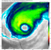
High tide is at 2:00 pm.......not good.This is the GFS simulated satellite for THU offshore of Charleston... focus on the eyewall actually onshore woth a huge eye
SUMMARY OF 200 PM EDT...1800 UTC...INFORMATION
----------------------------------------------
LOCATION...27.5N 78.7W
ABOUT 65 MI...105 KM N OF FREEPORT GRAND BAHAMA ISLAND
ABOUT 105 MI...170 KM E OF FORT PIERCE FLORIDA
MAXIMUM SUSTAINED WINDS...110 MPH...175 KM/H
PRESENT MOVEMENT...NW OR 325 DEGREES AT 5 MPH...7 KM/H
MINIMUM CENTRAL PRESSURE...959 MB...28.32 INCHES
I hope so.... T-2 and counting.....all it needs is a tad.a dollar to a doughnut we see a change in the cone at 5:00 ... a tad west ...
The Euro has done well imo. It was the first model to show that long stall on runs a number of days ago that some wouldn't believe. Once it had the stall, every run afterward had it. It not getting kudos would be ridiculous and ignoring reality. OTOH, the UKMET had some awful runs into the GOM.

Dam, the 12Z Euro is kind of worrying me for even here. It comes within 75 miles of SAV now and is getting closer to a Matthew type track. Matthew was about 35 miles from SAV. It had been as much as 150 miles away yesterday. I didn't expect this shift and hope it goes back.
Was hoping I wouldn't have to use my well inland hotel reservations. Now my hope is lowered somewhat.
UK/Euro/GFS are all on top of each other, give or take 20 miles. The 12z Euro just hugs the coastline all the way up, never makes landfall that I can see. Reminds me of Matthew track.
Correction: Makes landfall over MHX. This run is slower to, up the coast.
Yep all models have trended slower...

Yeah yesterday's Euro never had Dorian crossing 80W... this run a much different story, is getting close Larry, one model run or a trend?Dam, the 12Z Euro is kind of worrying me for even here. It comes within 75 miles of SAV now and is getting closer to a Matthew type track. Matthew was about 35 miles from SAV. It had been as much as 150 miles away yesterday. I didn't expect this shift and hope it goes back.
Was hoping I wouldn't have to use my well inland hotel reservations. Now my hope is lowered somewhat.
I wonder if his weakening has brought the steering so low that it has gained a sig westerly component vs the higher steering layers.

my 2¢'s ... trend ... some digging up top that wasn't there 6 hours ago ...Yeah yesterday's Euro never had Dorian crossing 80W... this run a much different story, is getting close Larry, one model run or a trend?
View attachment 23003
Notice also how the heaviest rainfall are also translating over to the north and western side of Dorian on all the guidance as well. Bodes grim for increased rain and Win threats all along the coasts...
Liked for you sharing the info not for liking what it is showing. I see what you're saying. I'm about 15 miles inland and yesterday's 18Z and today's 0Z Euro had only 2.5" of rain here. The 6Z had 3" and this 12Z run suddenly has 9"!

I will take this timing though the Euro is a good 10-12 hrs slower than all other models and thats seems suspect, at least it's a daytime hit.....the others hit mostly overnight.....
Really just brushes it, of course depending on the size of the eye as too how far west the western eyewall would be. Actually was further west early but may have shifted slightly east along the NC coast.Looks like it hits the OBX dead on.


No.Because of the geographic advantage of GA vs most of SC, they put GA only in a TS warning whereas to the north and south it is an H warning. If this 12Z Euro trend continues, they may very put GA in an H warning. GA is in a H watch now.
Last 3 runs....that's what I meant about my question "is the door closing".my 2¢'s ... trend ... some digging up top that wasn't there 6 hours ago ...

SUMMARY OF 300 PM EDT...1900 UTC...INFORMATION
----------------------------------------------
LOCATION...27.6N 78.7W
ABOUT 65 MI...105 KM N OF FREEPORT GRAND BAHAMA ISLAND
ABOUT 105 MI...170 KM E OF FORT PIERCE FLORIDA
MAXIMUM SUSTAINED WINDS...110 MPH...175 KM/H
PRESENT MOVEMENT...NW OR 325 DEGREES AT 5 MPH...7 KM/H
MINIMUM CENTRAL PRESSURE...959 MB...28.32 INCHES
Feel your angst ... it's been 25 - 50 miles for days ... and still is ...All it has to do is hit cape fear on NNE heading versus scraping the capes and that makes the biggest difference for weather from Raleigh to the east. I'm in TS watches with hurricane watches one county east so 25 to 30 miles one way or the other is a big thing for us.