Downeastnc
Member
12Z GFS has Debby dead at 150 hrs over central Alabama...can see a new storm entering GOM


I keep thinking Floyd part two. Remember these type pictures:Yeah some of these runs are big bad for the central and eastern Carolina's river systems.....just last night the headwaters of the Tar here in eastern NC got 4-5 inches and there is already a good chunk of water headed downstream....
View attachment 149363

Lived it. Stood looking on as a fast water rescue was underway for a man who was swept away. He did not survive. Stood in my parents back yard and watched them rescue people by helicopter across the highway along the tar River.I keep thinking Floyd part two. Remember these type pictures:
View attachment 149365

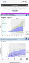
She's trying View attachment 149367
Yeah, that is the far eastern track with the current cone from the NHC.NHC says "There is significant uncertainty in the track of Debby in
the 2-5 day time frame."
12z ICON for this period.
View attachment 149366
I keep thinking Floyd part two. Remember these type pictures:
View attachment 149365
Kid lives right at Lockwood Folly. Let me know if you come across any tide gauge, flood etc web sites, to keep tabs on things. Im looking now, sure they are out there and I think you are in Brunswick County, when you moved, correct? Thanks in Advance!


Yeah I'm 1 mile or so west of the brunswick river in leland.
Try shagger Jack's restaurantHeaded to Oak Island tomorrow for a few days of a pre-planned vacation. Who knows how long we will be there before we have to leave since we will be along the coast.
Sent from my iPhone using Tapatalk
Have fun until Tuesday early.Headed to Oak Island tomorrow for a few days of a pre-planned vacation. Who knows how long we will be there before we have to leave since we will be along the coast.
Sent from my iPhone using Tapatalk

I'm fairly elevated here and neighbors have said this area does t flood so we will see@Shaggy get your insurance updated?
I"M TELLING you, if Model projections (hold) this might, look like Floyd(s) child play..
I know, I lived in Town Creek back in those days.. (Winnibow)..
I recall, seen what 133 going to SouthPort was/looked like.. After Floyd..
You very well might have the Cape fear River AND Town creek in/under/OVER your house!
I heard FEMA insurance is pretty cheap. My bro pays under 100 dollars a month for his and he lives in Florida.@Shaggy get your insurance updated?
I"M TELLING you, if Model projections (hold) this might, look like Floyd(s) child play..
I know, I lived in Town Creek back in those days.. (Winnibow)..
I recall, seen what 133 going to SouthPort was/looked like.. After Floyd..
You very well might have the Cape fear River AND Town creek in/under/OVER your house!
Looks quite a bit further west than Fayetteville to me. Looks like it stalls over Lumberton then makes the slow trek up to Burlington, NC.12Z Euro: LF 50 miles SW of 0Z Euro or 15 miles SW of Myrtle Beach then moving NNW. This is also 100 miles N of the 12Z UKMET hour 96.
Then to Florence followed by Fayetteville as it weakens.
Extremely heavy rain CHS to MYR.
Trying to plug in on Fema,Gov maps, assess things is painstaking. Ugh.. Maybe its where im using phone. Ill try again tommorow at work. Just trying to get a good idea. House was built post Florence, so thats best rule of thumb to use around those neck of woods. Again, if not needed for Debby, she will contribute heavily to the next one. What made Floyd so bad was Dennis, then Floyd going into a comma ,not moving hardly over eastern NC@Shaggy, your "neighbors are full of (sh) it".. That (hood) didn't exist before, Florence, much less Floyd..
Might as well just close all day tomorrowSavannah City Schools will release early tomorrow during the storm and be closed Tuesday and Wednesday.
They willMight as well just close all day tomorrow