• Hello, please take a minute to check out our awesome content, contributed by the wonderful members of our community. We hope you'll add your own thoughts and opinions by making a free account!

Hurricane Debby

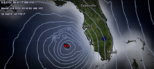
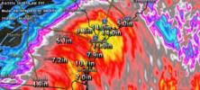
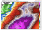
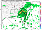
0Z Euro: similar track to 12Z but stronger with it coming back into CHS at 986 mb vs 989 on 12Z; biblical rainfall amts of 20-24” mainly over ~72 hr period SAV-CHS and inland to 50 miles Lowcountry:

IMG_0053.png
 
0Z Euro: similar track to 12Z but stronger with it coming back into CHS at 986 mb vs 989 on 12Z; biblical rainfall amts of 20-24” mainly over ~72 hr period SAV-CHS and inland to 50 miles Lowcountry:

View attachment 149244
2ft of rain around Parris Island would be devastating. I would love the 6" here in Union County but would like to see a different solution for the SC low country.
 
The 00Z runs have some pretty big zig zags in the track from GA north....not sure what to make of the jumps in track when it gets near the SC coast, seem wonky. Its almost like the models cant decide if the storm is going to track just inland or just offshore and keep hopping back and forth between the two....though the west shift to inland is pretty evident in the last couple of cycles.
 
Last edited:
The 00Z runs have some pretty big zig zags in the track from GA north....not sure what to make of the jumps in track when it gets near the SC coast, seem wonky. Its almost like the models cant decide if the storm is going to track just inland or just offshore and keep hopping back and forth between the two....though the west shift to inland is pretty evident in the last couple of cycles.
Agreed, looking back through the different models they all seem to be the same but just different specific locations. It diffidently slows around the GA/SC line and up through NC. Was a weird hour of runs.
 
Cliff notes: it's coming to Big Bend area and will possibly be a hurricane although we are not showing it yet as that on our map.
After that we don't have a clue. GFS says one thing and Euro another. (Been there once or twice before)

----------------

Tropical Depression Four Discussion Number 4
NWS National Hurricane Center Miami FL AL042024
500 AM EDT Sat Aug 03 2024

Small bursts of deep convection have continued near the estimated
center of the depression, with some skeletal convective bands over
the outer portions of the circulation. Earlier scatterometer data
revealed the strongest winds were occurring to the south and east of
the center, offshore of the southern coast of Cuba. The overall
organization of the tropical cyclone has changed little overnight,
and the initial intensity is held at 25 kt based on the earlier
scatterometer winds and recent Dvorak estimates from TAFB and SAB.

The estimated motion of the depression is still west-northwestward
at about 14 kt. The influence of an upper-level trough over the
eastern United States should cause the cyclone to turn northwestward
and then northward this weekend as it moves toward a break in the
subtropical ridge. This motion will bring the system across western
Cuba this morning, into the eastern Gulf of Mexico later today, and
toward the Florida Big Bend region on Sunday and Sunday night. There
is reasonably good confidence in this portion of the track forecast,
and only slight westward adjustments were made to the NHC prediction
based on the latest track consensus aids. After landfall, weakening
steering currents should cause the cyclone to slow down while it
moves northeastward over parts of northern Florida and Georgia.
Thereafter, the track forecast becomes highly uncertain as it is
unclear whether the system will accelerate northeastward ahead
of an upper trough (GFS) or get left behind and meander over
the southeastern U.S. or near the coast (ECMWF).

After the system crosses Cuba and emerges over the eastern Gulf of
Mexico, the environmental and oceanic conditions appear favorable
for intensification. The latest NHC forecast shows the cyclone
becoming a tropical storm by tonight, with additional strengthening
expected while it moves across deep warm waters in a weak shear
environment. The regional hurricane models and statistical guidance
continue to indicate some potential for the system to reach
hurricane strength before it makes landfall in the Florida Big Bend
region. Although the latest NHC forecast does not explicitly show
the cyclone becoming a hurricane, note that additional strengthening
could occur between 48-60 h. Weakening is forecast after landfall
while the system moves over the southeastern United States. Beyond
day 3, the intensity forecast remains quite uncertain and highly
dependent on whether the center stays inland or emerges off the
Atlantic coast.


Key Messages:

1. Heavy rainfall may result in locally considerable flash and urban
flooding across portions of Florida and the coastal areas of the
Southeast U.S. this weekend through Wednesday. Isolated river
flooding will also be possible.

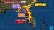
2. A Hurricane Watch has been issued for portions of west-central
Florida and the Big Bend region, where hurricane conditions are
possible late Sunday. Tropical storm conditions are expected
farther south along Florida’s west coast, including the Tampa Bay
area, and across the Dry Tortugas where Tropical Storm Warnings are
in effect.

3. There is a possibility of life-threatening inundation from storm
surge along portions of the west coast of Florida from Bonita Beach
to Aucilla River, including Tampa Bay and Charlotte Harbor, where a
Storm Surge Watch is in effect.

4. Impacts from storm surge, strong winds, and heavy rains are
possible elsewhere in Florida and along the southeast coast of the
United States from Georgia to North Carolina through the middle of
next week, and interests in those areas should continue to monitor
the progress of this system. Additional watches and warnings will
likely be required later today.


FORECAST POSITIONS AND MAX WINDS

INIT 03/0900Z 22.0N 80.7W 25 KT 30 MPH
12H 03/1800Z 23.4N 82.6W 30 KT 35 MPH
24H 04/0600Z 25.3N 83.9W 40 KT 45 MPH
36H 04/1800Z 27.5N 84.3W 50 KT 60 MPH
48H 05/0600Z 29.1N 83.9W 60 KT 70 MPH
60H 05/1800Z 30.4N 83.1W 45 KT 50 MPH...INLAND
72H 06/0600Z 31.2N 82.2W 35 KT 40 MPH...INLAND
96H 07/0600Z 32.0N 80.5W 45 KT 50 MPH...OVER WATER
120H 08/0600Z 33.0N 79.0W 55 KT 65 MPH
 
Big difference between the ICON and GFS....the ICON makes more sense to me as that track kinda fits historically....the big due east back due west motion the GFS shows is just weird...but tropical storms are weird sometimes.
GFS is actually an improvement from 0Z as it gets a little more offshore.
 
The center this morning may be just north of the convetive blob near the caymans but visible satellite just let us know in the next hour. As we go through the day into tonight this should start getting some outflow help from the right entrance to the jet along the EC, this may help it some convectively as well. It'll be interesting to see what this looks like around this time tomorrow as it's in a much better environment and away from Cuba. The track after the first landfall in Florida is nightmare fuel. You can make a case for a steady N to NNE motion as easy as you can the hard right, stall, hard left track.
 
It might be the NAM but it was much further W than all the previous runs, taking it now into S central GA vs the coast. If it remains at 12Z we'll have to see how the other models follow but if we aren't seen that N component as much as expected now, it's not going into the Atlantic how its currently modeled
 
Back
Top