Getting closer to my thoughts. I have 120mph landfall in Florida and 80mph landfall on Tybee Island, Georgia. I will adjust tomorrow as needed.
-
Hello, please take a minute to check out our awesome content, contributed by the wonderful members of our community. We hope you'll add your own thoughts and opinions by making a free account!
You are using an out of date browser. It may not display this or other websites correctly.
You should upgrade or use an alternative browser.
You should upgrade or use an alternative browser.
Hurricane Debby
- Thread starter Brent
- Start date

Belle Lechat
Member
- Joined
- Aug 29, 2021
- Messages
- 1,547
- Reaction score
- 1,224

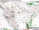
Orange lines are my attempt to curve a line. In short, the curve drops down towards the southeast.
Belle Lechat
Member
- Joined
- Aug 29, 2021
- Messages
- 1,547
- Reaction score
- 1,224

1005>1001>1006
Shaggy
Member
Icon is buying into the NW turn like gfs and euro. Still does it further north near the SC/NC border
How much do we think this will impact Valdosta? My mama is already getting stressed out. They had a hell of a time last year.
About like last year probably.How much do we think this will impact Valdosta? My mama is already getting stressed out. They had a hell of a time last year.
Once again, the GFS goes offshore and then comes back to the coast (5th run in a row), this time just S of me (furthest S yet I think) giving me TS wind gusts combined with the very heavy rain probably causing many uprooted trees. I need a generator.
So far a wild run on the GFS, find it hard to believe but who knows!
iGRXY
Member
GFS drops a nice 2-4” here while the Canadian goes all out on almost a foot even here.
Belle Lechat
Member
- Joined
- Aug 29, 2021
- Messages
- 1,547
- Reaction score
- 1,224
1215 PM EDT FRI 02 AUGUST 2024
SUBJECT: TROPICAL CYCLONE PLAN OF THE DAY (TCPOD)
VALID 03/1100Z TO 04/1100Z AUGUST 2024
TCPOD NUMBER.....24-063
I. ATLANTIC REQUIREMENTS
1. POTENTIAL TROPICAL CYCLONE FOUR
FLIGHT ONE - TEAL 71 FLIGHT TWO - NOAA 43
A. 03/1800Z A. 04/0000Z
B. AFXXX 0204A INVEST B. NOAA3 0304A CYCLONE
C. 03/1600Z C. 03/2030Z
D. 24.2N 81.5W D. 25.1N 82.3W
E. 03/1730Z TO 03/2230Z E. 03/2100Z TO 04/0200Z
F. SFC TO 15,000 FT F. SFC TO 15,000 FT
G. LOW-LEVEL INVEST G. TAIL DOPPLER RADAR
H. WRA ACTIVATION H. WRA ACTIVATION
FLIGHT THREE - NOAA 42 FLIGHT FOUR - TEAL 72
A. 04/1200Z A. 04/1130Z,1730Z
B. NOAA2 0404A CYCLONE B. AFXXX 0504A CYCLONE
C. 04/0900Z C. 04/1000Z
D. 27.2N 83.0W D. 27.1N 83.0W
E. 04/0930Z TO 04/1500Z E. 04/1100Z TO 04/1730Z
F. SFC TO 15,000 FT F. SFC TO 15,000 FT
G. TAIL DOPPLER RADAR G. FIX
H. WRA ACTIVATION H. WRA ACTIVATION
2. OUTLOOK FOR SUCCEEDING DAY:
A. CONTINUE 6-HRLY FIXES IF SYSTEM DEVELOPS AND REMAINS A
THREAT.
B. NOAA 43 P-3 TAIL DOPPLER RADAR MISSION INTO PTC 4 FOR
05/0000Z, DEPARTING KLAL AT 04/2100Z.
The color was to make it easier to read.
Next flights on station 5:30-1:00 EDT, departing :30 earlier and 7:00-3:30 EDT, departing 1:00 earlier.
A. Fix/Invest Time
B. Mission Identifier
C. Departure Time
D. Forecast Position
E. Time on Station
F. Altitude(s) on Station
G. Remarks (if needed)
Last edited:
Belle Lechat
Member
- Joined
- Aug 29, 2021
- Messages
- 1,547
- Reaction score
- 1,224

0Z UKMET: LF slightly E of prior runs in W Big Bend; then to SC GA to SE of Augusta, then E/NE to NE SC, E NC, NC coast, Newfoundland; once again, UKMET moves much more quickly than GFS/Euro and gets to NC by 108…so again not the huge flood threat of GFS/Euro on this much more common path:
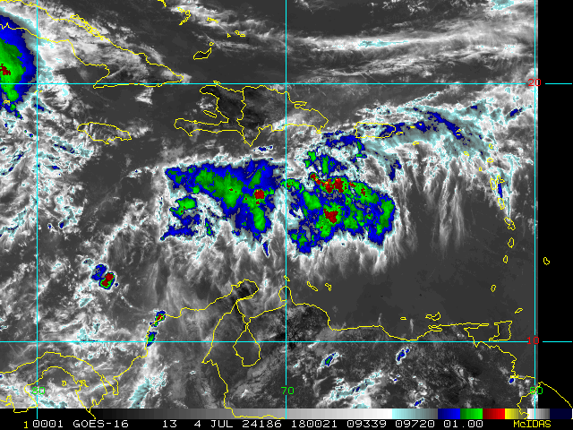
TROPICAL STORM DEBBY ANALYSED POSITION : 23.5N 83.2W
ATCF IDENTIFIER : AL042024
LEAD CENTRAL MAXIMUM WIND
VERIFYING TIME TIME POSITION PRESSURE (MB) SPEED (KNOTS)
-------------- ---- -------- ------------- -------------
0000UTC 04.08.2024 0 23.5N 83.2W 1006 31
1200UTC 04.08.2024 12 26.6N 84.1W 1003 45
0000UTC 05.08.2024 24 28.4N 84.3W 1000 46
1200UTC 05.08.2024 36 29.8N 84.2W 1000 39
0000UTC 06.08.2024 48 31.0N 83.6W 1002 34
1200UTC 06.08.2024 60 33.0N 82.3W 1000 41
0000UTC 07.08.2024 72 33.0N 81.6W 996 40
1200UTC 07.08.2024 84 34.0N 79.4W 994 40
0000UTC 08.08.2024 96 34.4N 77.6W 993 39
1200UTC 08.08.2024 108 35.6N 75.4W 995 45
0000UTC 09.08.2024 120 38.9N 73.4W 997 39
1200UTC 09.08.2024 132 41.4N 69.8W 996 43
0000UTC 10.08.2024 144 45.5N 61.7W 997 39
1200UTC 10.08.2024 156 48.9N 50.0W 996 39
0000UTC 11.08.2024 168 52.5N 32.8W 992 39
Belle Lechat
Member
- Joined
- Aug 29, 2021
- Messages
- 1,547
- Reaction score
- 1,224


Belle Lechat
Member
- Joined
- Aug 29, 2021
- Messages
- 1,547
- Reaction score
- 1,224
Progress
I don't know what kind of drugs the 00Z GFS model run was on. But that was one heck of a wild ride it just took us onSo far a wild run on the GFS, find it hard to believe but who knows!

Last edited:
0Z Euro: for 1st run since the one from 48 hours ago, the model not surprisingly based on history/climo totally abandoned the come back to lower SC or GA NW move and instead is a more normal from that position NNE move from the ocean to the SC/NC border and then up the E coast to MD followed by a move offshore. It never moves even just W of due N the entire time once out of the Gulfexcept for hours 96-102, when it went barely W of due N.
That leaves only the GFS and the 0Z CMC with the funky trek NW to WNW back into the SE. I’ll be looking for it to also abandon this craziness. Let’s see what the next runs of these models do.
Corrected for CMC
That leaves only the GFS and the 0Z CMC with the funky trek NW to WNW back into the SE. I’ll be looking for it to also abandon this craziness. Let’s see what the next runs of these models do.
Corrected for CMC
Last edited:
00Z HMON AND HWRF HAVE LANDFALL NEAR APALACHICOLA AND SPLITING THE AL-GA-FL LINE THE TRACKING OFF TO THE NE 
Belle Lechat
Member
- Joined
- Aug 29, 2021
- Messages
- 1,547
- Reaction score
- 1,224
2:00 AM EDT Sun Aug 4
Location: 24.9°N 83.9°W
Moving: NW at 14 mph
Min pressure: 1003 mb
Max sustained: 45 mph

Location: 24.9°N 83.9°W
Moving: NW at 14 mph
Min pressure: 1003 mb
Max sustained: 45 mph
I didnt see that, I saw them hitting the panhandle and then zig zagging around. Not so close to AL. Okay, maybe the HWRF but it still doesnt make sense. Those runs looked like the tricyclye race on revenge of the nerds.00Z HMON AND HWRF HAVE LANDFALL NEAR APALACHICOLA AND SPLITING THE AL-GA-FL LINE THE TRACKING OFF TO THE NE

Belle Lechat
Member
- Joined
- Aug 29, 2021
- Messages
- 1,547
- Reaction score
- 1,224

ENCSnowdawg
Member
00Z ICON- Cat 2 hurricane, NC/SC border landfall.
00Z GFS- GA coast.
00Z EURO- Strong TS/Cat 1, Myrtle Beach, SC landfall.
00Z GFS- GA coast.
00Z EURO- Strong TS/Cat 1, Myrtle Beach, SC landfall.
ENCSnowdawg
Member
NHC don't make changes on graphics for intermediate advisories.
Belle Lechat
Member
- Joined
- Aug 29, 2021
- Messages
- 1,547
- Reaction score
- 1,224
It shows the change in position and tropical force wind field.NHC don't make changes on graphics for intermediate advisories.
Belle Lechat
Member
- Joined
- Aug 29, 2021
- Messages
- 1,547
- Reaction score
- 1,224

THE HWFR LANDS IN APALACHICOLA GOES NE INTO GA AND DANCES AROUND IN SW GA THEN GET BACK IN THE GOM AND THE LANDS NEAR GULF SHORES IN ALABAMAI didnt see that, I saw them hitting the panhandle and then zig zagging around. Not so close to AL. Okay, maybe the HWRF but it still doesnt make sense. Those runs looked like the tricyclye race on revenge of the nerds.


Can anyone post the Euro, I also notice that most models initialize weaker than what was found by the hurricane hunters
ENCSnowdawg
Member
ICON as well.0Z Euro ensemble mean follows the operational to some extent with a higher % taking the progressive/much more normal route up/near the E coast than any of the prior 4 runs.
ENCSnowdawg
Member
Can anyone post the Euro, I also notice that most models initialize weaker than what was found by the hurricane hunters
Attachments
Thank you!
Belle Lechat
Member
- Joined
- Aug 29, 2021
- Messages
- 1,547
- Reaction score
- 1,224

Belle Lechat
Member
- Joined
- Aug 29, 2021
- Messages
- 1,547
- Reaction score
- 1,224

Belle Lechat
Member
- Joined
- Aug 29, 2021
- Messages
- 1,547
- Reaction score
- 1,224
ENCSnowdawg
Member
00Z & 18Z Euro Ensembles (0-120h)


Belle Lechat
Member
- Joined
- Aug 29, 2021
- Messages
- 1,547
- Reaction score
- 1,224
Belle Lechat
Member
- Joined
- Aug 29, 2021
- Messages
- 1,547
- Reaction score
- 1,224

ENCSnowdawg
Member
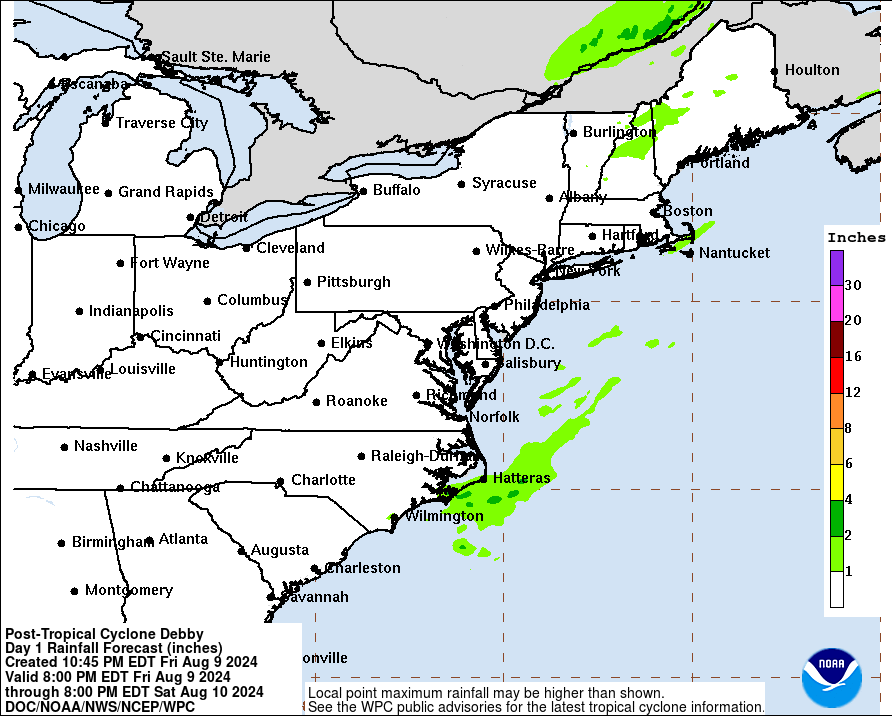
Catastrophic flood event.
Belle Lechat
Member
- Joined
- Aug 29, 2021
- Messages
- 1,547
- Reaction score
- 1,224
Any idea how often they get rain amounts like that?Catastrophic flood event.