Really?
WHERE...PORTIONS OF SOUTHEAST GEORGIA, INCLUDING THE FOLLOWING
AREAS, BULLOCH, CANDLER, COASTAL BRYAN, COASTAL CHATHAM, COASTAL
LIBERTY, COASTAL MCINTOSH, EFFINGHAM, EVANS, INLAND BRYAN, INLAND
CHATHAM, INLAND LIBERTY, INLAND MCINTOSH, JENKINS, LONG, SCREVEN
AND TATTNALL AND SOUTHEAST SOUTH CAROLINA, INCLUDING THE FOLLOWING
AREAS, ALLENDALE, BEAUFORT, CHARLESTON, COASTAL COLLETON, COASTAL
JASPER, DORCHESTER, HAMPTON, INLAND BERKELEY, INLAND COLLETON,
INLAND JASPER AND TIDAL BERKELEY.
* WHEN...FROM LATE TONIGHT THROUGH FRIDAY MORNING.
* IMPACTS...POTENTIALLY HISTORIC RAINFALL AMOUNTS WILL LIKELY RESULT
IN SEVERE WIDESPREAD FLASH FLOODING.
* ADDITIONAL DETAILS...
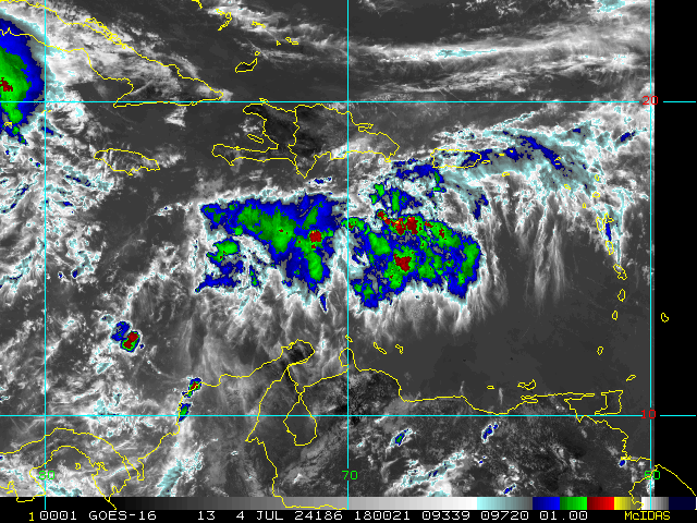
- TROPICAL STORM DEBBY IS EXPECTED TO STALL NEAR THE AREA MID
TO LATE WEEK. WIDESPREAD RAINFALL AMOUNTS OF 10 TO 20 INCHES,
WITH LOCAL AMOUNTS TOWARD 30 INCHES ARE EXPECTED.
-
HTTP://www.weather.gov/SAFETY/FLOOD


.png")
