LickWx
Member
Because we are all a bunch of sadists who want to see him suffer ?Why is that unfortunate ?
Because we are all a bunch of sadists who want to see him suffer ?Why is that unfortunate ?
If you knew Ji, you’d know. He’s the most hostile, toxic weenie to ever post on a weather forum. Unlike most weenies, he’s not even funny, he’s just mean.Why is that unfortunate ?

I agree 100% When the Wind is out of the NE, I always knew models would be too warm at 2m and usually a good recipe for wintry weather (if a other parameters behaved as well).You are exactly right. From the late 70's, 80's and even part of the 90' we had real Cad events. Not anymore though. Growing up before social media and weather models free to the public a rules of thumb was "the wind has to be blowing from the NE for us to get a major storm".

Unfortunately, Ji is in Leesburg out past IAD, and it seems to still be snowing there.
Dry slot is here. Temp on the hill holding at 30 with airport at 33/30. Holding out hope it stays cool and what swings through late afternoon has a chance to overcome the warm nose. NAM says it rain so ...
Scratching my head at this though:
This Afternoon
Snow and sleet. High near 32. Light and variable wind becoming northwest around 5 mph. Chance of precipitation is 100%. Total daytime snow and sleet accumulation of 1 to 3 inches possible.
Tonight
Snow and sleet, mainly before 2am. Low around 32. Northwest wind 3 to 7 mph. Chance of precipitation is 100%. New snow and sleet accumulation of less than a half inch possible.
Maybe point and click is busted.

That's more like mine too. I intentionally chose the city for the warmest option. I don't want to bash because hey have an incredibly hard job and miller B setups just totally suck. But it is weird that all we had was ZR and yet the S word is prominent in the forecast.This is what I get when I put my zip code into the Blacksburg site. Something isn't right there lol. If we switch back to snow I think at most we may get a coating.
Detailed Forecast
This Afternoon
Snow before 3pm, then snow and sleet. High near 32. Calm wind becoming northwest around 5 mph. Chance of precipitation is 100%. Total daytime snow and sleet accumulation of 2 to 4 inches possible.
Tonight
Rain, snow, and sleet, mainly before 3am. Low around 32. Northwest wind 3 to 7 mph. Chance of precipitation is 100%. New snow and sleet accumulation of less than a half inch possible.
That's more like mine too. I intentionally chose the city for the warmest option. I don't want to bash because hey have an incredibly hard job and miller B setups just totally suck. But it is weird that all we had was ZR and yet the S word is prominent in the forecast.
Looks like IAD went over to ZR at 2 PM, though. 32/ZR as of 3 PM, up from 31 at 2 PM. They could slip above freezing and get some plain old RN soon. Looks like IAD had about fourish hours of snow with maybe a couple tenths liquid equivalent, so I’m guessing they got 1-2”, which I think was a low end bust.Damn
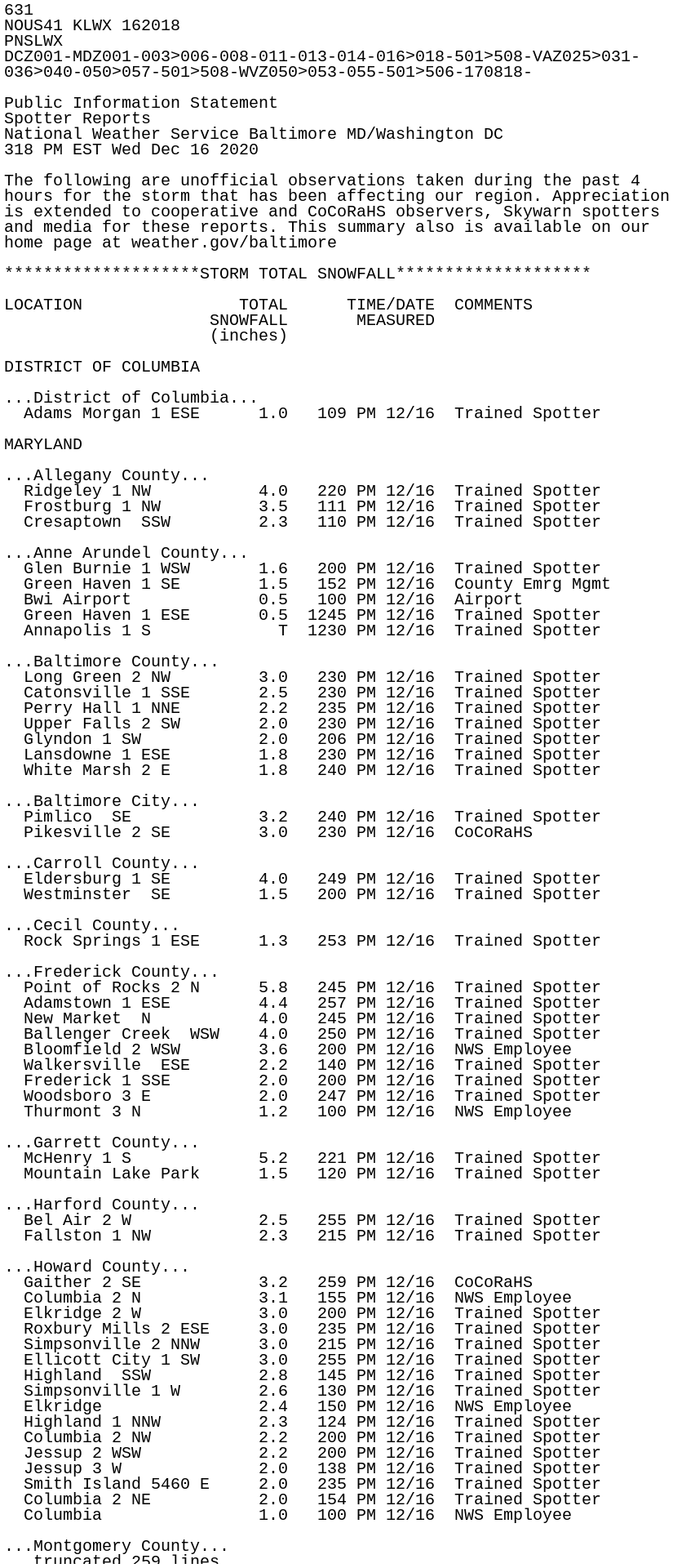
...Loudoun County...
  Hillsboro 3 NW          5.0   238 PM 12/16  Trained Spotter
  Leesburg 2 NW           4.0   307 PM 12/16  Trained Spotter
  Countryside 2 ESE       4.0   145 PM 12/16  Trained Spotter
  Purcellville            3.5   215 PM 12/16  NWS Employee
  Hughesville 1 ESE       3.5   230 PM 12/16  Trained Spotter
  Leesburg 2 WSW          3.0   253 PM 12/16  Trained Spotter
  Arcola 1 NNE            2.8   137 PM 12/16  Trained Spotter
  Dulles International    2.1   130 PM 12/16  Airport
  Arcola 2 SSE            2.0   140 PM 12/16  Trained Spotter
  Ashburn 3 WSW           2.0   115 PM 12/16  NWS Employee
  Countryside 3 ESE       1.8   305 PM 12/16  Trained Spotter
NoOnce day I’ll get under a band like this here in the upstate View attachment 58179