What it that bad?
No, I mean a Euro run on the rocks as in on ice as in cold.
")
Actually, the 0Z Euro is somewhat colder v the 12Z. Also, the 0Z EPS is overall colder for the E US vs its 12Z run.
What it that bad?
Read H5 people, don't look the surface temp maps or they will drive you crazy.
Yeah if we get stuck in a zonal flow it's going to be like threading a needle in a wind tunnel trying to get some snow around hereWell TWC just showed how the US goes zonal for first 2 weeks in February, looked like some of the op runs have been showing, with extreme cold hugging the Canada border!
Yeah if we get stuck in a zonal flow it's going to be like threading a needle in a wind tunnel trying to get some snow around here
I agree. It's not likely we are in a zonal pattern that long after this transient cold and warmth.There’s no way we get zonal flow for the first two weeks. TWC cant predict a pattern for the next 21 days, no matter how hard they try. They’re wrong.
I thought we didn't have a SE ridge in December I thought it showed up on the long range and then got beaten backNobody knows what will happen. We could end up with a similar pattern to Dec with the SE ridge being stubborn, which is consistent with La Niña tendencies, especially in February, and is what model consensus is suggesting MAY happen. But that also may make it easier for northern/well inland locations to have a winter storm threat at some point.
If we did it wasn't much of one. Just enough to allow the historic snow here. I will take that again lol.I thought we didn't have a SE ridge in December I thought it showed up on the long range and then got beaten back
I think the models finally killed it around Christmas after it had been showing up every model run 300+ hours out. Christmas looked like it would torch then when it finally came temperatures fell during the day when Santa clause finally came. Back and forth just like we're seeing now in the LEI thought we didn't have a SE ridge in December I thought it showed up on the long range and then got beaten back
I thought we didn't have a SE ridge in December I thought it showed up on the long range and then got beaten back

Wow I wouldn't of thought we were above normal. Guess 2 years of torching will do that to you.i'm talking about the month as a whole. This is consistent with most of the SE being slightly warmer than normal (RDU was an exception) vs it being cold in the NE and northeastern Midwest:
View attachment 3426
I gotcha. The cold days seem to overshadow the warm days sometimes. I honestly thought we were right around average most of Decemberi'm talking about the month as a whole. This is consistent with most of the SE being slightly warmer than normal (RDU was an exception) vs it being cold in the NE and northeastern Midwest:
View attachment 3426
If that's true Webb posted something about that on here yesterday for febuary. Same concept?Here's the H5 anomalies for December 2017. Pretty good illustrator of what happens aloft drives what happens at the surface.
View attachment 3427
I gotcha. The cold days seem to overshadow the warm days sometimes. I honestly thought we were right around average most of December
i'm talking about the month as a whole. This is consistent with most of the SE being slightly warmer than normal (RDU was an exception) vs it being cold in the NE and northeastern Midwest:
View attachment 342


Or Nassau if this pattern is anything like early JanuryThose slp probably be in Chicago in a few days LoL
Sent from my iPhone using Tapatalk
They also showed January being above average for most of the US well into the cold snap.Well TWC just showed how the US goes zonal for first 2 weeks in February, looked like some of the op runs have been showing, with extreme cold hugging the Canada border!
i'm talking about the month as a whole. This is consistent with most of the SE being slightly warmer than normal (RDU was an exception) vs it being cold in the NE and northeastern Midwest:
View attachment 3426


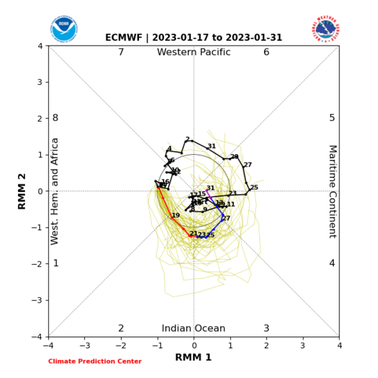
Is this good for us?Wow what a classic Maritime Continent MJO pulse. The upper level anticyclone (shown here using stream function which shows the component of the flow that's purely rotational) and downstream trough near and just north of Japan initiated primarily by geostrophic adjustment and downstream development from RW dispersion respectively, are right where you'd expect it to be.
View attachment 3430
View attachment 3428
View attachment 3429
Active MJO means more storm chances.Is this good for us?
Why are these graphics so bad. They look like the daily drawings my toddler brings home from school. We should create better graphicsWow what a classic Maritime Continent MJO pulse. The upper level anticyclone (shown here using stream function which shows the component of the flow that's purely rotational) and downstream trough near and just north of Japan initiated primarily by geostrophic adjustment and downstream development from RW dispersion respectively, are right where you'd expect it to be.
View attachment 3430
View attachment 3428
View attachment 3429
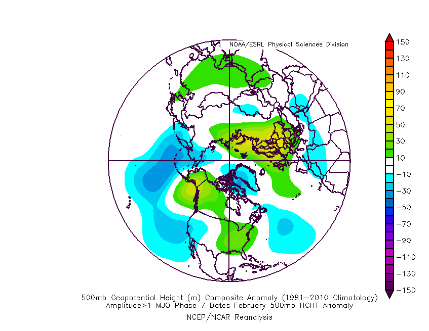
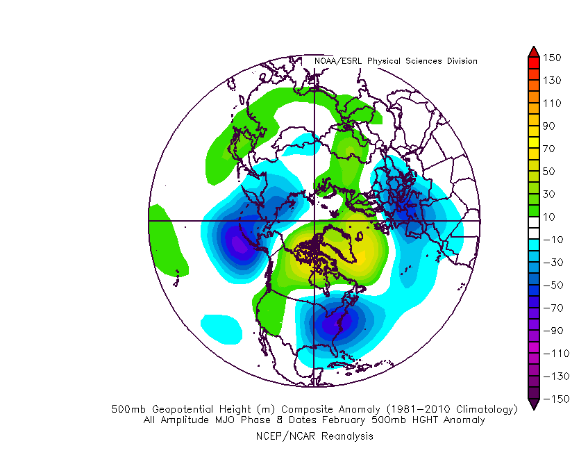
Yesh, doesn't seem like the models are much help at this point, but it's hard to just be patient and wait for a storm, making it more difficult not to take note of them. The MO doesn't really tell much about how cold it's gonna get or how stormy. I know everybody keeps saying not to look for a storm and not pay attention to warm maps, but it's still hard for me at least. Especially when you look at H5, I don't think know it really tells you that much about how cold it's gonna be or if it'll be cold enough.Here's what the pattern will likely generally evolve from and into by the second half of February, assuming the MJO continues on as predicted. I am barely even looking at NWP guidance at this point.
There is a +PNA showing in the latest outlook. Maybe this and possibly an active southern jet will crank something good out of the gulf.What is the PNA outlook for Feb? If still +PNA, it might not matter if we are cold.
What is the PNA outlook for Feb? If still +PNA, it might not matter if we are cold.