• Hello, please take a minute to check out our awesome content, contributed by the wonderful members of our community. We hope you'll add your own thoughts and opinions by making a free account!

Pattern Freezing Ferocious February

What am I missing? PV split?

View attachment 3958


View attachment 3959

...and I'm just asking a serious question ....

The PV split has nothing to do with the winter of 90-91, warm winter overall as the maps show, I was just giving an example of when to expect modeling to reflect the consequences of a PV split - which is Day 14 or so. 1991 was an analog I identified along with 1985, back on Jan 23rd long before Cohen wrote his blog posts identifying the exact same two years as analogs for this PV split. 1985 is more closely related as it was a weak La Niña and E QBO year. These analogs are preferred because of the irregularity in the splitting, which in both years and like the current PV split ongoing, leaves a large sister lobe over North America.

The PV split didn’t result in much in the way of snow, we actually didn’t do well in 1991, but it at least brought winter back even if it was short lived. Here’s a RDU chart:

6ee9cd93809f21255e610e189185963b.jpg


Salt needed though, as no PV event is alike and the fact that we have two very different analogs should tell you something...we’re in uncharted territory and the truth is no one knows what late Feb holds, it’s a coin flip.


Sent from my iPhone using Tapatalk
 
The EPS runs doesn't get much worse for cold weather, we need the inverse of what it's showing. Not saying it's correct but GEFS moved in this direction too. These models are moving around some but none are moving towards colder weather in the east.

14-km EPS Global Northern Hemisphere 5-day Avg 500Z Anom 360.png
 
The PV split has nothing to do with the winter of 90-91, warm winter overall as the maps show, I was just giving an example of when to expect modeling to reflect the consequences of a PV split - which is Day 14 or so. 1991 was an analog I identified along with 1985, back on Jan 23rd long before Cohen wrote his blog posts identifying the exact same two years as analogs for this PV split. 1985 is more closely related as it was a weak La Niña and E QBO year. These analogs are preferred because of the irregularity in the splitting, which in both years and like the current PV split ongoing, leaves a large sister lobe over North America.

The PV split didn’t result in much in the way of snow, we actually didn’t do well in 1991, but it at least brought winter back even if it was short lived. Here’s a RDU chart:

6ee9cd93809f21255e610e189185963b.jpg


Salt needed though, as no PV event is alike and the fact that we have two very different analogs should tell you something...we’re in uncharted territory and the truth is no one knows what late Feb holds, it’s a coin flip.


Sent from my iPhone using Tapatalk
Thanks, Jon!
Appreciate the explanation. I was not connecting the dots and assumed some sort of equation.
My bad!
Best!
Phil
 
The EPS runs doesn't get much worse for cold weather, we need the inverse of what it's showing. Not saying it's correct but GEFS moved in this direction too. These models are moving around some but none are moving towards colder weather in the east.

View attachment 3961
Yep, unfortunately. I keep hoping to wake up and see a turn for the better in the overnight runs. Instead, they give me the morning runs. The buffet is shut down!
 
The EPS runs doesn't get much worse for cold weather, we need the inverse of what it's showing. Not saying it's correct but GEFS moved in this direction too. These models are moving around some but none are moving towards colder weather in the east.

View attachment 3961
The gefs was a trend away from previous colder runs and looks more like the eps now
a0d8fffd67bb3ea5205d9c785223e610.jpg
ad12f4336706bf867a951bffd8bc208b.jpg


00z eps

Sent from my SM-J320VPP using Tapatalk
879d0d63d5bcbcd88ec8ffde819bbb99.jpg
9738622ae72342fa1f14589920ace61f.jpg
 
Last edited:
The gefs was a trend away from previous colder runs and looks more like the eps now

00z eps

Sent from my SM-J320VPP using Tapatalk

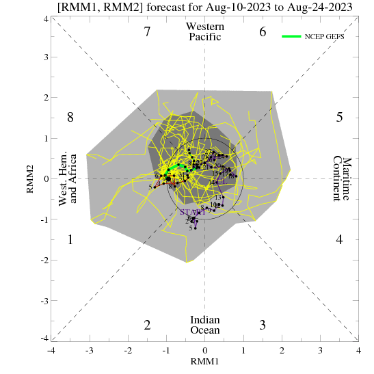
I guess we shouldn't be surprised, this fits phase 7 MJO and nina climo. We are going to spend almost 3 weeks in high amplitude phase 7. Even phase 8 for FMA MJO temperature composites is mostly a conus torch. Phase 1-2-3 for FMA are well below normal though.

ECMF_phase_MANOM_51m_small.gif Screen Shot 2018-02-11 at 10.05.36 AM.png
 
MJO the ghost of 8, 1 and 2... It's stuck in phase 7 see you in March
NCPE_phase_21m_small.gif


Hits keep coming enjoy the warmer weather... Can't complain over 10" of snow this season but always the great white hope in March long shot but always there
 
Yeah, it's confusing and frustrating. Models are everywhere and it doesn't even look like legit storms are forming anywhere on the Eastern half of the country. Just waves of energy. What the hell is going on?

Not for temperatures. For the SE US, they have been very consistently warm for many days of runs going out 15 days.
 
I can understand pattern changes being rushed by models but this delay of going into phase 8 by the MJO seems a bit crazy. Longer we go the more that I may want to skip phase 8. As if it keeps stalled seemingly there for long, before long it'll be late March when we finally get it and it's going to cause headaches again with fruit crops.
 
I can understand pattern changes being rushed by models but this delay of going into phase 8 by the MJO seems a bit crazy. Longer we go the more that I may want to skip phase 8. As if it keeps stalled seemingly there for long, before long it'll be late March when we finally get it and it's going to cause headaches again with fruit crops.
Yep, I heard the peach growers in GA are expecting a great year ahead from the cold air we had earlier this year and it would be bad if they start to flower and we get a cold snap. I think we all may be throwing in the towel by the end of the month though.
problem is, MJO is helping driving the pattern, and in phase 7 that does NOTHING for us......other than bring us rain. *btw, which we need*
I agree completely about the rain part. Let's take the drought down quite a bit if we can't get wintry weather. The lake is only 2.53 feet down now from all this rain and has been sharply rising. In addition, parts of the SE have gone from below average for the year to above since the rain began.
full.php
 
Back
Top