FamouslyHot
Member
WEBB, or anyone else....I think I have asked before (sorry if have) any maps to that FEB 1973 storm?
WEBB, or anyone else....I think I have asked before (sorry if have) any maps to that FEB 1973 storm?


Thank you! GA or Bama as well? plus wanted to see if we have any H5 or SFC maps that he might have.
WEBB, or anyone else....I think I have asked before (sorry if have) any maps to that FEB 1973 storm?

Thank you. Selfishly, would love that storm around here...hahahThis is the SC-based map I worked on last night & today. I went thru all of the written publications from voluntary observers for this storm and read a few pieces of literature for additional observations that are missing from most maps & documents you'll find out there. I also added several obs (like the 6.5" in Laurens, SC for ex) based on snow liquid ratios from adjacent stations.
View attachment 70733
Hi everyone. There's been a ton of banter in the main discussion thread over the past couple of days. We've been addressing individuals as fast as we can. If you see a post that you think is in the wrong thread, please use the REPORT feature. If you post banter in the discussion thread, you will be issued a warning and timeouts will be given as the warnings accumulate.
-3 warnings is a 1 day ban
-5 is a 2 day ban
-8 is 3 day ban
-10 is a permanent ban on your account
Please think carefully before posting! Thank you for your support!
This guy's blog is about as detailed as I've seen for the time.WEBB, or anyone else....I think I have asked before (sorry if have) any maps to that FEB 1973 storm?

 weatherclimatematter.blogspot.com
Might sneak out a severe weather setup before we switchIn the absence of a -NAO, I'd certainly be concerned about the coming cold staying held back over the Rockies & midwest, but I highly doubt it does as long as we have a giant west-based -NAO in place. It's probably a matter of when not if it gets really cold down here. I've personally been yearning for a couple 60-70F days lately here in NC and it's nice that we might finally seem them
View attachment 70726
View attachment 70728
View attachment 70725
View attachment 70729
View attachment 70731
Thank you! GA or Bama as well? plus wanted to see if we have any H5 or SFC maps that he might have.
Thank you. Selfishly, would love that storm around here...hahah


I made this a while back but forgot to post it. Here are the pretty precip maps for that storm.Thank you! GA or Bama as well? plus wanted to see if we have any H5 or SFC maps that he might have.

I made this a while back but forgot to post it. Here are the pretty precip maps for that storm.
I posted this site this morning, but you can search through some more parameters.
ECMWF ERA5 (Reanalysis) | 02/09/1973, 09:00pm | USA
Historical weather maps from 02/09/1973, 09:00pm, USA - Geopotential height, 500hPa (m) | ECMWF ERA5 (Reanalysis)weather.us
I made this a while back but forgot to post it. Here are the pretty precip maps for that storm.
I posted this site this morning, but you can search through some more parameters.
ECMWF ERA5 (Reanalysis) | 02/09/1973, 09:00pm | USA
Historical weather maps from 02/09/1973, 09:00pm, USA - Geopotential height, 500hPa (m) | ECMWF ERA5 (Reanalysis)
Very popular storm. I've posted this one three times!Need to see Mar 1980 now thanks.....
Thank you! GA or Bama as well? plus wanted to see if we have any H5 or SFC maps that he might have.
Thank you! I know the look, as of now, doesn't really look like this but I really could see a good southern slider system for the I-20 corridor south and I-85 and I-40 south. To me....as of now...the pattern screams potentialI don't blame ya. I know NWS ILM has made a nice map of the snow from this storm. I could probably make a more localized one for south-central GA if you'd like.
View attachment 70737
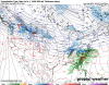
Here's the z500 vort near the peak of this storm during the night of the 9th into the 10th.
View attachment 70736
Here's the hemispheric 500mb anomaly map I pulled from NOAA ESRL. Tbh, it was a crappy-looking pattern in a large-scale sense that triggered this storm
View attachment 70738
Thank you!Here ya go, delta: http://raleighwx.americanwx.com/Feb1973/Feb1973.html
The first link should have H5 or SFC maps associated with the storm.


Are you ready for the cold ? Looks like you will have highs between 0 and 5 for several days with lows -15 to -20 !Here is a snippet from James Spann!!!
LONG RANGE IDEAS: While the idea of Arctic air entering the Deep South next week is now off the table, we note very cold air will be looming north of here through next week. Temperatures this morning over Alaska were as cold as -40F, and that kind of air covers much of western Canada and the Arctic region. That air is heavy, and at some point will have to move.
One run of the American GFS model today shows a big snow/ice event for Alabama in 10 days. You will see that plastered all over social media, but it is meaningless at this point. Having said that, the players are on the field for some potential for winter mischief by mid-month. Arctic air and an active southern branch of the jet stream will be watched closely. But, we could go through the entire month of February without a winter storm threat; this is Alabama after all. But, it wouldn’t be a big shock if we have at least a chance of wintry precipitation within the next three weeks. We will see.
I made this a while back but forgot to post it. Here are the pretty precip maps for that storm.
I posted this site this morning, but you can search through some more parameters.
ECMWF ERA5 (Reanalysis) | 02/09/1973, 09:00pm | USA
Historical weather maps from 02/09/1973, 09:00pm, USA - Geopotential height, 500hPa (m) | ECMWF ERA5 (Reanalysis)
lots of EPS members have a light event View attachment 70685View attachment 70686View attachment 70687


Oh come on now View attachment 70756View attachment 70757

We really have to give the ICON some credit for spotting this.wedges by 00z tomorrow? At least there’s no S/W trough (yet) View attachment 70758
Oh come on now View attachment 70756View attachment 70757


Think we can get a two-for-one deal on the wedges?lol that increase of ridging in the NPAC really changed everything, were trending towards a favorable look for severe over winter in the medium range View attachment 70761
And oh....View attachment 70760View attachment 70762

All factz!This front end warm makes perfect sense for deep southern snows. Many times I've heard stories of warm to snow within a week from older people.

This front end warm makes perfect sense for deep southern snows. Many times I've heard stories of warm to snow within a week from older people.


Yeah I think most of SC except for the northern Upstate and eastern NC will sneak a mild day, but I have a feeling the rest of us will be wedge in out ahead of this front. There’s just such a good snowpack to our north now and with that -NAO it’s gonna be hard to stay out of that wedge. For the folks that do get 60s/70, they might get to experience one of my favorite weather events... the 25+ degree day to day temp droplol that increase of ridging in the NPAC really changed everything, were trending towards a favorable look for severe over winter in the medium range View attachment 70761
And oh....View attachment 70760View attachment 70762