• Hello, please take a minute to check out our awesome content, contributed by the wonderful members of our community. We hope you'll add your own thoughts and opinions by making a free account!

Pattern February Discussion Part II

Status
Not open for further replies.
Sign me up
f64018e051dc9d7d46ce1073603c2732.jpg


Sent from my SM-G928V using Tapatalk
 
People on here are talking about a big Northwest Trend but if we have massive blocking in Greenland it actually could trend South toward Suppression if anything!!! Now with that being said I WANT SOME FLURRIES IN SOUTH CAROLINA THATS ALL I NEED!!!:):)

Greenland block isn't that important for Dixie systems imo. It mainly helps with New England systems. Much more direct impact there.


Sent from my iPhone using Tapatalk
 
cmc runs pretty far inland for the storm on the 16th, fwiw.

I'm intrigued by the storm on the 16th but I need to see some more support for a colder solution and southern slider.
 
Last edited:
a nice day 9 system for you. weenie run for Carolinas between days 7-10

Sent from my SM-G900V using Tapatalk
Yep. I'll set the percentage of verification generously at 10%. That second system is awesome though I'd love to just see that happen.

Sent from my SM-G928V using Tapatalk
 
cmc is an apps runner for the storm on the 16th, fwiw.

I'm intrigued by the storm on the 16th but I need to see some more support for a colder solution and southern slider.
not an apps runner . slides ots off the Carolina coast

Sent from my SM-G900V using Tapatalk
 
This may sound silly, but I'm really getting a 2/25/15 vibe off this one. That one was very marginal temp wise and really didn't show up to be a significant threat until four days out.

Hmmmm.
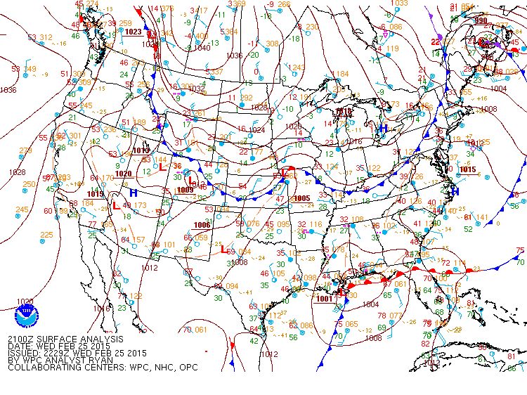
Was that the storm where Atlanta was under a Winter Storm Warning and got screwed and ended up with nothing ?
 
not an apps runner . slides ots off the Carolina coast

Sent from my SM-G900V using Tapatalk
Yeah that's pretty close to pound city here but as has been said ad Nauseum the cold is lacking

Sent from my SM-G928V using Tapatalk
 
This may sound silly, but I'm really getting a 2/25/15 vibe off this one. That one was very marginal temp wise and really didn't show up to be a significant threat until four days out.

Hmmmm.
sound silly ? have you seen some of the posts in this thread.

I remember that one very well

Sent from my SM-G900V using Tapatalk
 
I just checked the 850 temps and there is some CAD going on. I'm not going to buy this what the GFS shows, we need Euro and ensemble support.

Sent from my SM-J700T1 using Tapatalk

The GFS typically has a strong cold bias and with the attendant too far south storm tracks as we've seen this season. However, I have recently realized that the one pattern it will probably perform better (little or no cold bias/storm tracks not too far south and, therefore, storm tracks not trending northward with time) with is a +PNA. I've gone on and on about the recent horrible GFS cold bias. However, because of the extremely high +PNA coming at the same time as this storm, I don't expect later GFS runs for around the time of this storm to keep getting warmer. In contrast, they may very well cool more and with the storm track likely staying in the Gulf. This is helped by mid Feb climo, which has about as far south an average storm track as at any time of winter along with the most concentrated activity in history for much of the SE.

Note that as strong of a PNA as the GFS has been forecasting for about a week, it is actually getting a little stronger from day to day. In addition, both the AO and the NAO have been trending much more in the negative direction the last few days for around the time if he storm. And the extremely high amp MJO phase 8 can't be ignored. Translation: trend is your friend. The GFS appears to be playing catchup to an extent. Note that these last two runs are the coldest of any GFS runs with the storm.

This is truly an exciting time to be a SE wx hobbyist. With a near record high +PNA, near record high Feb MJO amp 8, a very strongly -AO, a trend toward a -NAO and the best major snow climo of the winter all progged to collide, how can a hobbyist not be excited right now about the wild possibilities? I can say with confidence that this combo won't happen again
in our lifetimes. Does this mean a major winter storm for the SE? I don't know and neither does anyone else. But this extreme rarity of factors is maintaining my excitement about midmonth potential.
 
Larry, what is climo like for snow in late Feb ? Is there a fast dropoff in snow climo between Mid and Late Feb ?
 
At the risk of taking this waayyyy off topic, the risks that I remember as possibilities that were discussed before the 2/25/15 were a possible very sharp cutoff between a lot of snow and not much at all and the possibility of a dry slot not too far away from where the deform band set up. Well the very sharp cutoff happened and the deform band set up to where the dry slot was Atlanta, GA (at least parts of the area).

I was attending college in NW GA then and that was my favorite storm. All snow and it was wet.
It's amazing the different experiences in just 50 or so miles. That was your favorite storm and that was my least favorite storm ever. When they say I-20 is the dividing line between rain and snow many times it is literally the case. Amazing how that works.
 
Larry, what is climo like for snow in late Feb ? Is there a fast dropoff in snow climo between Mid and Late Feb ?

No. It drops off somewhat in frequency at places I've analyzed (like ATL, CAE thanks to Shawn's chart, CHS, SAV). However, it still is rather active at both ATL and CAE. It is that it hasn't been quite as active as the relatively very active 2nd week/midmonth period. Actually, at CAE, late feb is still easily the 2nd most active with regard to the history of major snowstorms (again thanks to Shawn for posting that list).
 
Larry,
I'm excited about the possibilities but not that excited yet cause we're 6-7 days away from this event and there's no model agreement with the Euro. 12z Euro is warmer and track of low is further north.

Now of course, if the Euro starts to trend towards what the GFS has been showing, then I'll sign up.


Sent from my SM-J700T1 using Tapatalk
 
No. It drops off somewhat in frequency at places I've analyzed (like ATL, CAE thanks to Shawn's chart, CHS, SAV). However, it still is rather active at both ATL and CAE. It is that it hasn't been quite as active as the relatively very active 2nd week/midmonth period.
You may not have this info off the top of your head, but do you remember the last time Atlanta had a major snow or ice event in the 2nd half of Feb ( between Feb 15-29 ) ?
 
Larry,
I'm excited about the possibilities but not that excited yet cause we're 6-7 days away from this event and there's no model agreement with the Euro. 12z Euro is warmer and track of low is further north.

Now of course, if the Euro starts to trend towards what the GFS has been showing, then I'll sign up.


Sent from my SM-J700T1 using Tapatalk

I still don't like what the GFS is showing. You need high pressure. It's a requirement for significant Dixie snow events. What the GFS showed was like 2-8" of snow from atl to cae falling into upper 30s and lower 40s. I know it's attainable, but temperatures that high at the surface won't drop 10 degrees easily.

And you won't get a simple warmer/cooler trend. You need a high pressure to get any more of a cooling trend, imo.


Sent from my iPhone using Tapatalk
 
I'm still keeping an eye on that 11+ day system. Not getting into details of my thoughts about it just quite yet.

Sent from my SM-J700T1 using Tapatalk
 
But this system does look like 2/25/15. If I had to pick an analog it'd be that one.


Sent from my iPhone using Tapatalk
 
Larry,
I'm excited about the possibilities but not that excited yet cause we're 6-7 days away from this event and there's no model agreement with the Euro. 12z Euro is warmer and track of low is further north.

Now of course, if the Euro starts to trend towards what the GFS has been showing, then I'll sign up.

Sent from my SM-J700T1 using Tapatalk

This sounds reasonable. Believe me, I want to see the King support this. IF there really is going to be a SE storm, one would think the Euro runs will eventually show it.
 
Suppressed is definitely what we want in this range.


Sent from my iPhone using Tapatalk
I agree, it's a nice change as previous runs had been showing a good amount of apps runners. there is still 1 or 2 showing that but for the most part the members are south

Sent from my SM-G900V using Tapatalk
 
I agree, it's a nice change as previous runs had been showing a good amount of apps runners. there is still 1 or 2 showing that but for the most part the members are south

Sent from my SM-G900V using Tapatalk

e255790811c312568b1468f1fc1a3caf.jpg


All in for the GFS 00z LMBO!


Sent from my iPhone using Tapatalk
 
I still don't like what the GFS is showing. You need high pressure. It's a requirement for significant Dixie snow events. What the GFS showed was like 2-8" of snow from atl to cae falling into upper 30s and lower 40s. I know it's attainable, but temperatures that high at the surface won't drop 10 degrees easily.

And you won't get a simple warmer/cooler trend. You need a high pressure to get any more of a cooling trend, imo.


Sent from my iPhone using Tapatalk
Yes, that is another issue, a HP needs to be to the NW of the system to help filter in the colder air. The cold air is there, but it's not being forced. There definitely needs to be a high cause the low and high will be working together to help bring the cold air in.

Sent from my SM-J700T1 using Tapatalk
 
You may not have this info off the top of your head, but do you remember the last time Atlanta had a major snow or ice event in the 2nd half of Feb ( between Feb 15-29 ) ?

2/17-18/1979 4" sleetstorm (Tony special).
 
I agree, it's a nice change as previous runs had been showing a good amount of apps runners. there is still 1 or 2 showing that but for the most part the members are south

Sent from my SM-G900V using Tapatalk

I'm still worried about low level temps. We need either
1) massive amplification of the pna ridge
2) a high pressure to form to our northwest.

The first looks more likely but, of course, that option usually brings most uncertainties. And in a time of pattern change, the results of said pna ridge will likely be underdone at this range.

It'd be nice to get both though, still attainable.


Sent from my iPhone using Tapatalk
 
I still don't like what the GFS is showing. You need high pressure. It's a requirement for significant Dixie snow events. What the GFS showed was like 2-8" of snow from atl to cae falling into upper 30s and lower 40s. I know it's attainable, but temperatures that high at the surface won't drop 10 degrees easily.

And you won't get a simple warmer/cooler trend. You need a high pressure to get any more of a cooling trend, imo.


Sent from my iPhone using Tapatalk

No its not a requirement, it helps no doubt, but there are exceptions.

sfc_25_21Z.gif
 
No its not a requirement, it helps no doubt, but there are exceptions.

sfc_25_21Z.gif

Yes. That's a possible top analog.

But I was mainly talking about i20 snow events. Right through the south.


Sent from my iPhone using Tapatalk
 
I'm keeping an eye on the 11+ day system becuase

1. On the 0z GFS there is a HP to the NW and N of the system.

2. As of right now, it could be a Miller A system and it's a strong system.

3. 0z GFS shows signs of some CAD, surface temps are warm but their not showing in the 60s or 70s. Temps are showing in the 30s and 40s.

4. Ridgeing out west and to the NE. May have a +PNA and a -NAO.

Sent from my SM-J700T1 using Tapatalk
 
What HP? The nearest significant HP is in far far NW Canada.

There's a weak high pressure system and inverted ridge off of Chesapeake. Otherwise it wouldn't be 37 degrees in Atlanta ahead of the leading fropa!


Sent from my iPhone using Tapatalk
 
What HP? The nearest significant HP is in far far NW Canada.

And besides the weak HP, the system included a phased setup. Right now, the upcoming setup does not look phased. That's why temps are progged warm.


Sent from my iPhone using Tapatalk
 
Thanks for the info. Hard to believe it's been nearly 40 years since ATL had a major winter event in the 2nd half of Feb.

YW. What's amazing is that at ATL there was not one, not 2, not 3, 4, or 5 but a whopping SIX major snow or Tony storms just within the 18 year period 1885-1902!! Yes, one major snow or sleet every 3 years on average just for 2/15-28!! They were not just during El Niño but also during neutrals as well as La Ninas! During the 1880's-1910, Feb was by far King of the ATL major winter storm with far more during that month than during any other month! Interestingly, back then Feb was quite a bit colder on average vs the last 30+ years, but Jan is now about the same as it was then.
 
Status
Not open for further replies.
Back
Top