Ron Burgundy
Member
Rates! Rates! Rates will overcome!!After all of GAWX data last night about Atlanta and snow with SW winds, I can't say i'm surprised unfortunately.
Rates! Rates! Rates will overcome!!After all of GAWX data last night about Atlanta and snow with SW winds, I can't say i'm surprised unfortunately.
Finally started here in Ooltewah. Went from a few flurries to a good moderate snow in just a few minutes. Everything that is falling is sticking. Very nice to see because we moved to Ooltewah from East Ridge in 2016. In 3 1/2 years we have had a grand total of less than 1/2" of snow. Our yard has never even been white. It's already starting to get a little white so that's a start.East Ridge.
24 degrees here in Hiawassee. Waiting?I'm up to 31.8 now

50 minutes of virga before anything fell here. Already a dusting. The frost was awesome for that!!We've warmed to 28 here but I don't expect to go too much higher as the virga will begin to transition to actual snow soon.


 www.theedwinhotel.com
Fort Oglethorpe Ga.Where you at?

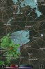
Much better moisture look but is still too slow as Virga is already in Rabun county so those in the upstate look really good in my opinion. Granted that easily could change.12z HRRR now saying let it snow! Looks betterView attachment 33515
It’s ripping in East Ridge!congrats to Chattanooga - use to live there (and really miss it!)
looks like mod snow near DT - must be ripping on Signal or Lookout!
Snowing here In Hiawassee GeorgiaIt’s 23° here, hoping it does not get above freezing before it gets here.
There's a small patch of snow popping up just a mile north of the airport ahead of the main precip. Virga probably, but reassuring to see.

Yeah it was just a blip. However virga is entering the northern part of the perimeter.im not so certain that wasn’t just a big ass flock of birds


Needs to hurry the F up. I’ve got very little wiggle room left in these britches. 32.7/ 31.5Yeah it was just a blip. However virga is entering the northern part of the perimeter.
Huge fail on temps and an aside, I know nothing to do with the snow but forecast of 29 here, HRRR had 30 but hit 24. Models are horrible with radiation cooling. ...Big fail by the hrrr
View attachment 33518
Yes it is we got to lock in this cold air before it gets to warmUp to 27 here in NW upstate but the clouds are rolling in pretty quick