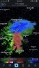
• Hello, please take a minute to check out our awesome content, contributed by the wonderful members of our community. We hope you'll add your own thoughts and opinions by making a free account!

Wintry February 7-8 Winter storm

Most precipitation that has come through this winter has been about 2-4 hours quicker than modeled. Let’s hope that holds true.
 
ALEET! ALEET!! I always wanted to say that. Never thought I would this winter.

URGENT - WINTER WEATHER MESSAGE
National Weather Service Peachtree City GA
347 PM EST Fri Feb 7 2020


GAZ001>009-011>016-019>025-030>035-045-080500-
/O.NEW.KFFC.WW.Y.0001.200208T0900Z-200208T1800Z/
Dade-Walker-Catoosa-Whitfield-Murray-Fannin-Gilmer-Union-Towns-
Chattooga-Gordon-Pickens-Dawson-Lumpkin-White-Floyd-Bartow-
Cherokee-Forsyth-Hall-Banks-Jackson-Polk-Paulding-Cobb-
North Fulton-Gwinnett-Barrow-DeKalb-
Including the cities of Calhoun, Dahlonega, Cleveland, Rome,
Cartersville, Gainesville, Marietta, Atlanta, Lawrenceville,
and Decatur
347 PM EST Fri Feb 7 2020

...WINTER WEATHER ADVISORY IN EFFECT FROM 4 AM TO 1 PM EST
SATURDAY...

* WHAT...Snow expected...mixed with rain at times. Total snow
accumulations of up to two inches...possibly three to four
inches at higher elevations. Amounts of generally less than an
inch possible for the Atlanta Metro area.

* WHERE...Generally north of Interstate 20 and east of Interstate
85.

* WHEN...From 4 AM to 1 PM EST Saturday.

* IMPACTS...Plan on slippery road conditions...especially on
bridges and overpasses...or during heavier bursts of snow.

* ADDITIONAL DETAILS...Temperatures are expected to warm by
afternoon so a transition to all rain should bring improving
conditions. However the northeast mountains could continue to
see periods of snow through the day. Temperatures should drop
below freezing again Saturday night...making black ice possible
on Sunday morning.

*PRECAUTIONARY/PREPAREDNESS ACTIONS...

Slow down and use caution while traveling.

&&

$$

Am I missing something here where they are saying EAST of 85? I assume that is a typo.
 
Love living on the edge

namconus_asnow_seus_10.png
Especially here!
 
i've never done this before an event before but i checked every global and meso model i could find on tropical tidbits and they ALL have almost the same look ATL and Northward, for the most part (and at least in mby). So my question to you guys is do we often bust when there is that much agreement, or does this one seem pretty above average as far as model agreement. thank you and I'll take my answer offline.
 
I’m seeing some flakes mix in with the rain bands moving through Charlotte right now ... if we can get this light precip to mix with some flurries at this temperature today imagine what tomorrow would be like .. models just aren’t good with snow profiling as of recent
I will say while I’m at work and haven’t had a chance to see the NWS forecast, TWC has come down drastically on highs tomorrow in CLT. They’re down to a high of 42 when they were at 50 this morning
 
i've never done this before an event before but i checked every global and meso model i could find on tropical tidbits and they ALL have almost the same look ATL and Northward, for the most part (and at least in mby). So my question to you guys is do we often bust when there is that much agreement, or does this one seem pretty above average as far as model agreement. thank you and I'll take my answer offline.

The highest bust potential based on history imo is not whether or not any falls but how much (if any) accumulates due to it not being cold enough in marginal situations when precip isn't heavy like this one appears to be. Models often overdo accumulations more than the opposite...at least in ATL area. Just as a betting man as opposed to going with my feelings, I'd take the under on average model accumulations and hope for a rare bust the other way.

Example: remember last winter's bust near Macon?

But any just falling (2nd day in a row) would be a victory imo. I'd keep the accumulations expectations low in and near the city, itself, while still hoping for a surprise.
 
Got one for CLT ?
It's about 4 post up ;)

And some of y'all are going to have a great Saturday, also keep in mind, 9 out of 10 times precip moves in quicker then models show, so you have that going for you too. Good luck.... I'm not bitter I promise
 
The highest bust potential based on history imo is not whether or not any falls but how much (if any) accumulates due to it not being cold enough in marginal situations when precip isn't heavy like this one appears to be. Models often overdo accumulations more than the opposite...at least in ATL area. Just as a betting man as opposed to going with my feelings, I'd take the under on average model accumulations and hope for a rare bust the other way.

Example: remember last winter's bust near Macon?
While this is true this year has been different with no lack of moisture. Just look at what happened in SC. The models were playing catch up for sure there!
 
I think I’m solid on some flakes falling tomorrow in the golden strip area. Wouldn’t shock me to see a coating. Wouldn’t shock me to see nothing. Seems like a good attitude

Here in upstate we really have to hope this moves in 7-8am instead of 10am.


Sent from my iPhone using Tapatalk
 
The highest bust potential based on history imo is not whether or not any falls but how much (if any) accumulates due to it not being cold enough in marginal situations when precip isn't heavy like this one appears to be. Models often overdo accumulations more than the opposite...at least in ATL area. Just as a betting man as opposed to going with my feelings, I'd take the under on average model accumulations and hope for a rare bust the other way.

Example: remember last winter's bust near Macon?

But any just falling (2nd day in a row) would be a victory imo. I'd keep the accumulations expectations low in and near the city, itself, while still hoping for a surprise.
Can’t agree more. I bet snow will fall but I’ll count myself lucky to see a sloppy inch due to this. Luckily, the kids don’t need much snow to have fun.
 
The highest bust potential based on history imo is not whether or not any falls but how much (if any) accumulates due to it not being cold enough in marginal situations when precip isn't heavy like this one appears to be. Models often overdo accumulations more than the opposite...at least in ATL area. Just as a betting man as opposed to going with my feelings, I'd take the under on average model accumulations and hope for a rare bust the other way.

Example: remember last winter's bust near Macon?

But any just falling (2nd day in a row) would be a victory imo. I'd keep the accumulations expectations low in and near the city, itself, while still hoping for a surprise.
Not sure how they handle it up here. If it really is a heavy burst of snow I think the models may be on-par with what could happen, especially if rates are insane.
 
Back
Top