NBAcentel
Member
What did it look like compared to last run?
What did it look like compared to last run?


That 360hr threat might have some legs too. It's been flashing on the GEFS and CMCE as well.


Gefs trend is ugly, less 50/50, faster pacificThis was supposed to be our super terrific pattern. But someone made an apt point…the cold isn’t here. Doesn’t mean it can’t snow…just makes it harder.
View attachment 145849

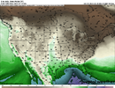
I still think the cold eventually dumps in the conus and we finally get something.Gefs trend is ugly, less 50/50, faster pacific View attachment 145850
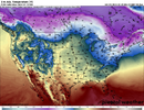
Looking at the individual runs. So many of them ruin our cold feed with the northern stream shortwave that runs over top of the southern shortwave. If we can reverse that trend better cold feed can be possible like the Euro is showingGefs trend is ugly, less 50/50, faster pacific View attachment 145850
I would trust euro and its ensembles more than gfs. Just look at how the gfs finally trended the valentines day threat northward more in line with euro guidance finally. Gfs has been getting its ass kicked last few weeksLooking at the individual runs. So many of them ruin our cold feed with the northern stream shortwave that runs over top of the southern shortwave. If we can reverse that trend better cold feed can be possible like the Euro is showing


Took me some comparing to see it, but now I see exactly what you're talking about comparing the op GFS with the Euro.Key from what I’m noticing to get the pattern going after and more favorable for that D9-10 threat, is progress the trough in the PNW east at D7, and extend it into the Atlantic trough, and have a height field that leans NW to SE, 06z EPS looked better for that, even more so then the 00z runView attachment 145854
The GEFS gets it hung out west to long, and the height field is more zonal, and it becomes a weakness, for more pac related energy View attachment 145855
Conclusion: we need that piece to move east, quickly, if it gets hung out west, it’s gonna link with the PT moving east, and the 50/50 would move out quick because it encourages a zonal look after, we need it to interact with the Atlantic trough and become a extension of the ATL trough, so there’s a renewed cold feed
I 100% agree, great analysis.Key from what I’m noticing to get the pattern going after and more favorable for that D9-10 threat, is progress the trough in the PNW east at D7, and extend it into the Atlantic trough, and have a height field that leans NW to SE, 06z EPS looked better for that, even more so then the 00z runView attachment 145854
The GEFS gets it hung out west to long, and the height field is more zonal, and it becomes a weakness, for more pac related energy View attachment 145855
Conclusion: we need that piece to move east, quickly, if it gets hung out west, it’s gonna link with the PT moving east, and the 50/50 would move out quick because it encourages a zonal look after, we need it to interact with the Atlantic trough and become a extension of the ATL trough, so there’s a renewed cold feed
Looks like storm out the gulf heading into cad .just unknown how deep the cold will beThe pacific looking mediocre isn't a killer for the 2/18ish system as long as the davis strait to 50/50 area plays along. It'll trend this to either a miller B or sheared wave scenario but if we have a 1032-1040 high moving from the lakes into the NE that plays for areas east of the apps.
I'm really interested to see where the follow up system around 2/24 goes as well. Have some potential with that one but have to worry it gets biased too far north or the remnant cold is too marginal
I like the start of the 12Z OP suite. A new look on the ICON. It's poised to bring an artic airmass down the front range with our Baja vorticity looming.


Yep. It would probably get very warm ahead of that clipper but that's the look you want ahead of the SS waveI like the start of the 12Z OP suite. A new look on the ICON. It's poised to bring an artic airmass down the front range with our Baja vorticity looming.

Yep, GFS coming in much less zonal

 Much better

If there is goin be one this winter season this is probably it.imoView attachment 145872
I smell a incoming soon

Since 12z yesterday, the trend has been to weaken the 50/50 low and strengthen the Pacific low further east. The 06z GEFS doesn't even get the 850 line south of I-40, while the EPS and CMC are much colder. The 12z GFS folded to the 00z EPS and CMC. However, the question remains: will the GEFS align with the OP, and will the EPS and CMC continue?Folding to who? Didn't it have back to back op runs with big SE snows yesterday? If anything its leading....or all alone actually.