Yeah… 2/26-27/2004 is a great example of that….the high on the 26th at CLT was 42 at midnight, but snowfall that day was 11.6”. On the 27th the high was 40 but there was still 1.7” of snowfall that date. Also the maps are ensemble means as well, if the pattern is right, the temperatures will be a lot lowerThis is the same man that shows a graph and constantly reminds people February is the snowiest month in Charlotte. I guess all that snow falls in the first half of February. This is a defeated meteorologist that's speaking with emotion just like we do on here. I get what he's saying, 15 below the average high won't do it. But 15 below the average low will. Plenty of snow days warmed to the 40s later in the day. Plenty also started in the 40s and radiational cooling took over. Even I can't believe this man said this. Especially still 10+ days out.
-
Hello, please take a minute to check out our awesome content, contributed by the wonderful members of our community. We hope you'll add your own thoughts and opinions by making a free account!
You are using an out of date browser. It may not display this or other websites correctly.
You should upgrade or use an alternative browser.
You should upgrade or use an alternative browser.
Pattern February 2024
- Thread starter SD
- Start date
Around 12/10/2022, he also posted that there would be no Arctic air coming around in the next several weeks around Christmas and that it was more likely that it would be 70 degrees at Christmas Day. Everyone on here could look at at every single index and and every single 500mb chart and know that was simply not true.He also went on to say in comments, "there is no arctic air on the way and no winter set-up. The cool anomalies are caused by rain and clouds, not cold air. That's why it's so warm north of the storm track." And later in comments "no signs of ridge and all the cold air is on the other side of the hemisphere in the long range." Not what I wanted to read this evening.
NBAcentel
Member
We are cooking 
NBAcentel
Member
Looking at comparisons at H5, this is pretty similar to the first week of December 2018, in some cases strikingly similar 

CNCsnwfan1210
Member
Ridge over Alaska and the 50/50We are cooking View attachment 145328

Sent from my SM-A136U1 using Tapatalk
CNCsnwfan1210
Member
Almost fits the miller B recipe to a T


Sent from my SM-A136U1 using Tapatalk


Sent from my SM-A136U1 using Tapatalk
Tarheelwx
Member
Fro,
Definitely very very similar. However, isn’t that major cross polar flow in 2018 vs not very much if any showing on the GFS Ensembles you posted above? That is what I see as the biggest difference and I’d think it could lead to a significantly different outcome from a temp standpoint. Thoughts?
TW
Definitely very very similar. However, isn’t that major cross polar flow in 2018 vs not very much if any showing on the GFS Ensembles you posted above? That is what I see as the biggest difference and I’d think it could lead to a significantly different outcome from a temp standpoint. Thoughts?
TW
NBAcentel
Member
This gefs run ends up wonky though because the TPV in can 
packfan98
Moderator
Let’s move the Brad P. Ongoing discussion to the banter thread please.
rburrel2
Member
Easy to see why the EPS is less ethnused with snow in the 288-360hr timeframe. It concentrates the PV lobe more over SE Canada, the GEFS/CMCE split a piece of it off further East near the Atlantic and that allows for some room for that southern wave to amplify.
The EPS is probably better for chances down the road after that, but worse for the day 10-15 threat window.
The CMCE is really the best of both worlds because it looks good long term too.
Just my two cents, but I'd really rather not have to can kick out past day 15 again which is pushing in to March, so I'm rooting for the CMCE/GEFS evolution. (also i'm out of town Feb 25th-March 2nd so that's affecting my rooting interests).
AJ1013
Member
Beautiful morning here. 55F with screaming NW winds and mostly cloudy skies. This is “winter” in this part of the world.
iGRXY
Member
While it certainly can snow in early March, I would definitely much rather have something between the 15th-25thEasy to see why the EPS is less ethnused with snow in the 288-360hr timeframe. It concentrates the PV lobe more over SE Canada, the GEFS/CMCE split a piece of it off further East near the Atlantic and that allows for some room for that southern wave to amplify.
The EPS is probably better for chances down the road after that, but worse for the day 10-15 threat window.
The the CMCE is really the best of both worlds because it looks good long term too.
Just my two cents, but I'd really rather not have to can kick out past day 15 again which is pushing in to March, so I'm rooting for the CMCE/GEFS evolution. (also i'm out of town Feb 25th-March 2nd so that's affecting my rooting interests).
I like the GEPS better...you can see why the placement of the PV in southern Canada is so important. The GEPS was the first to sniff out the stout blocking and I think it will lead the way in the PV progression, it just might be a smidge quick.


brad's sharp as a tack; odd take
that being said, can't be overstated how much these guys have to smother the flames and play bad cop against high schoolers with a wxbell account and that can be borne out with pessimistic tweets like this
Yeah this could never work 
personally i've always seen 3/1-3/10 as fruitful and as high potential as the rest of winter; for wilmington, for raleigh, for anywhere i've lived. i think after that chances fall off a cliff. you could argue you could sand a few days off on the low side these days as climate change chews into the feasibility of marginal events
- Joined
- Jan 23, 2021
- Messages
- 4,604
- Reaction score
- 15,203
- Location
- Lebanon Township, Durham County NC
We had a high of 43 or 44 degrees on 1/22/03. It was snowing, hard, by midnight and the rest is history. That is an odd take for him.brad's sharp as a tack; odd take
that being said, can't be overstated how much these guys have to smother the flames and play bad cop against high schoolers with a wxbell account and that can be borne out with pessimistic tweets like this
- Joined
- Jan 23, 2021
- Messages
- 4,604
- Reaction score
- 15,203
- Location
- Lebanon Township, Durham County NC
Those of us near the virginia border need to keep an eye on that mid term event. We're not that far off from backside snow, especially if it wraps up.
i'm definitely intriguedThose of us near the virginia border need to keep an eye on that mid term event. We're not that far off from backside snow, especially if it wraps up.
- Joined
- Jan 23, 2021
- Messages
- 4,604
- Reaction score
- 15,203
- Location
- Lebanon Township, Durham County NC
i'm definitely intrigued

WolfpackHomer91
Member
Nice look up around I-40

AJ1013
Member
Cody was enjoying the cool morning as well

That's a really pretty image. We know Friday, 2/16 won't look exactly like that. But if it's anywhere close to this, you have several key elements floating around that could generate a storm. It's a great look for getting legitimate cold air on our side of the world on our side of the US and has a real potential to combine that with an active STJ.Yeah this could never work View attachment 145354
There's lots of deleting going on across multiple threads. I don't know what the issue is over the last couple of days, but let's please lay off the banter in this thread and the name-calling and insulting in the other, or there are going to be quite a few posters taking a ride to the train station.
this thing aint diving to cuba i can tell you that much!!!!!!!That's a really pretty image. We know Friday, 2/16 won't look exactly like that. But if it's anywhere close to this, you have several key elements floating around that could generate a storm. It's a great look for getting legitimate cold air on our side of the world on our side of the US and has a real potential to combine that with an active STJ.
Stormlover
Member
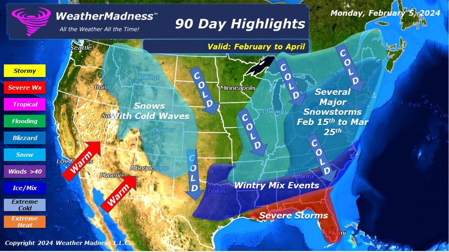
Weather Madness
@HenryMargusity
http://WeatherMadness.com is predicting a major pattern shift coming starting with the Valentines Day snowstorm. The eastern part of the country will have major snowstorms and colder weather well into March. At least one major East Coast snowstorm will occur during this pattern.
- Joined
- Jan 23, 2021
- Messages
- 4,604
- Reaction score
- 15,203
- Location
- Lebanon Township, Durham County NC
For those sports fans interested, the control run at 6z dug the mid term storm about 250-300 miles further SW into the big bend.
.png")

Weather Madness
@HenryMargusity
http://WeatherMadness.com is predicting a major pattern shift coming starting with the Valentines Day snowstorm. The eastern part of the country will have major snowstorms and colder weather well into March. At least one major East Coast snowstorm will occur during this pattern.
You have gotta love the ones who throw “severe weather” to the south of wintry mix zones because it is a “battle zone”.
That ain’t no Miller B footprint either. Idk who this guy is but it appears he’s all-in with @WilsonYou have gotta love the ones who throw “severe weather” to the south of wintry mix zones because it is a “battle zone”.
Kinda sucks rain is likely going to ruin what is going to be a really nice weekend temperature wise across the Southeast.
Tsappfrog20
Member
Kinda sucks rain is likely going to ruin what is going to be a really nice weekend temperature wise across the Southeast.
I know if the weekend is going to be messed up it might as well be with snow!!
Sent from my iPhone using Tapatalk
Henry at one time was an Accuweather met. He was fairly good at winter wx from what I rememberThat ain’t no Miller B footprint either. Idk who this guy is but it appears he’s all-in with @Wilson
Stormlover
Member
Sure was.Henry at one time was an Accuweather met. He was fairly good at winter wx from what I remember

Big changes by days 7-8 on this run. Colder earlier?

- Joined
- Jan 23, 2021
- Messages
- 4,604
- Reaction score
- 15,203
- Location
- Lebanon Township, Durham County NC
Last five runs of the GFS, centered on the location of the 500mb low from 12z today looking back:
Hour 162(Today 12z): Albemarle, NC
Hour 168(Today 6z): 50 miles E of the Delmarva peninsula
Hour 174(Today 0z): North Central Mississippi
Hour 182(Yesterday 18z): Jackson MS
Hour 188(Yesterday 12z): Bryan/College Station TX
Hour 162(Today 12z): Albemarle, NC
Hour 168(Today 6z): 50 miles E of the Delmarva peninsula
Hour 174(Today 0z): North Central Mississippi
Hour 182(Yesterday 18z): Jackson MS
Hour 188(Yesterday 12z): Bryan/College Station TX
Appetizer, Table-setter, etc.
- Joined
- Jan 23, 2021
- Messages
- 4,604
- Reaction score
- 15,203
- Location
- Lebanon Township, Durham County NC
to borrow from a tik tok trend, looking at that blocking makes me think "good googly moogly"

coldfront22
Member
Bull don't we want that 500mb low centered more south?