NBAcentel
Member
That’s a stout cad sig on the EPS 2mt 


Wonder if the euro is just holding back the shortwave to much, like it normally doesThat 2/13-14 system can get really really interesting in a hurry as models resolve the timing and the vortex or lack of over the NE. Realistically it should be a cold rain with a follow up system 2/16-17 being more interesting. With the euro being close to a last second phase though it has to make your eyebrows raise though
I think this is one we want held back. If it pops out too soon there's going to be a carcass of the SER and it'll be biased north like the gfs or bodily pulled into the meat grinder like the cmc. I would assume that the eps members with snow in the time frame are the slowestWonder if the euro is just holding back the shortwave to much, like it normally does
Ehhhh it depends. Usually the setup for CAD has a heighten field out ahead of the storm which helps drive it north before relocating to the coast. In this instance the heights across the east as depicted are lowered as you have troughs all across the 50/50 region and the southern United States due to El Niño influenceCAD just isn't a really good setup for snow in the Southeast. It can set the tone for ground temps, but getting those 850/925 temps where they need to be with solely CAD influence is a pretty hard thing to do. You need cold air funneling in from the NW and sliding east.

Just wait until the pattern starts to retrograde and the big western ridge returnsThis is the deepest dive yet on the EURO ext. Maybe we really can lock in the -NAO and bring March in like a lion.

That's interesting, the model backed off, now it's back at it again. I believe it did the same thing earlier. Regardless, the polar vortex is going to get smacked around awhile.This is the deepest dive yet on the EURO ext. Maybe we really can lock in the -NAO and bring March in like a lion.
For us SE of the Apps, the best setups are CAD combined with it being cold everywhere (surface on up). CAD isn't limited to ice / sleet storms. But CAD can help to give us folks SE of the Apps that extra bit of wiggle room to ensure a winter storm vs. a rainy oneCAD just isn't a really good setup for snow in the Southeast. It can set the tone for ground temps, but getting those 850/925 temps where they need to be with solely CAD influence is a pretty hard thing to do. You need cold air funneling in from the NW and sliding east.
Yep. It backed off quite a bit on yesterday's run. Of course, it should be noted that only a few days before the January SSW, it backed off a reversal at the last minute. Of interest, unlike in January, the PV doesn't look like it will rapidly recover this time.That's interesting, the model backed off, now it's back at it again. I believe it did the same thing earlier. Regardless, the polar vortex is going to get smacked around awhile.
Sent from my SM-A136U1 using Tapatalk
Yea, especially important in Feb/March to help negate boundary layer issues from sun angle.For us SE of the Apps, the best setups are CAD combined with it being cold everywhere (surface on up). CAD isn't limited to ice / sleet storms. But CAD can help to give us folks SE of the Apps that extra bit of wiggle room to ensure a winter storm vs. a rainy one
Ideally, I look for a banana high here at the tail end of CAD country.For us SE of the Apps, the best setups are CAD combined with it being cold everywhere (surface on up). CAD isn't limited to ice / sleet storms. But CAD can help to give us folks SE of the Apps that extra bit of wiggle room to ensure a winter storm vs. a rainy one
I feel you dawg!Just wait until the pattern starts to retrograde and the big western ridge returns


Some of the Carolina Piedmont and SC upstate best snowstorms have come from CADCAD just isn't a really good setup for snow in the Southeast. It can set the tone for ground temps, but getting those 850/925 temps where they need to be with solely CAD influence is a pretty hard thing to do. You need cold air funneling in from the NW and sliding east.
You stole my thunder here lol. I was just about to post the last handful of days in feb into the first week of March might have the biggest of dogsThat has a Feb-Mar 1960 look to it where the Atlantic side is dominant and doing its thing
View attachment 145443
View attachment 145444
Wow! That truly is a dead-ringer.That has a Feb-Mar 1960 look to it where the Atlantic side is dominant and doing its thing
View attachment 145443
View attachment 145444
All I know is that it better have snowed in Lavonia, Ga during that time or there's just no hope for that town.Wow! That truly is a dead-ringer.
I know 1960 was epic for the Carolinas. How did Ala. and Ga. do that year? Does anyone have that handy?
")


Cool article on Feb 12th 1960Wow! That truly is a dead-ringer.
I know 1960 was epic for the Carolinas. How did Ala. and Ga. do that year? Does anyone have that handy?
I don’t have the snowfall map but according to this Atlanta had 4 inches on March 11, 1960. https://www.currentresults.com/Year...e-annual-atlanta-snowfall.php#google_vignetteWow! That truly is a dead-ringer.
I know 1960 was epic for the Carolinas. How did Ala. and Ga. do that year? Does anyone have that handy?
I don't think it was as epic as NC but I know GA did quite well.Wow! That truly is a dead-ringer.
I know 1960 was epic for the Carolinas. How did Ala. and Ga. do that year? Does anyone have that handy?
CLT had 25" of snow across 3 events across 10 days in March 1960...RDU was around 15".I don't think it was as epic as NC but I know GA did quite well.

For March 1960, CLT had 21.7” it’s still the snowiest month in the city’s history. The total for the winter was 25” and all of that occurred after 2/12… there was a storm that gave the city 3.3” over Valentine’s Day. The first of the March storms was on 3/2 and gave CLT 9.5”… one of many big snowstorms to happen 3/2 which is the reason why 3/2 is on average the snowiest day of the year in CLTCLT had 25" of snow across 3 events across 10 days in March 1960...RDU was around 15".
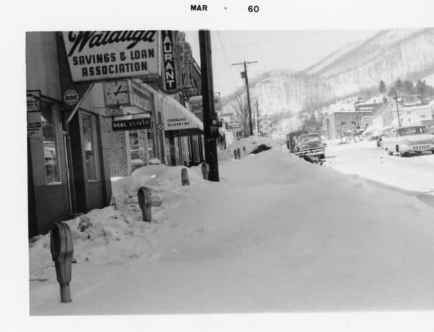
That was my mom’s freshman year at App St. She said that the school never cancelled classes that month. Of course it was much smaller and just a teacher’s college at that point with all students living on campusThe Valentines Close enough to watch storm at 12z, Had the 12z Icon in the neighborhood. Be interesting to see if we can pull a rabbit out of the hat. And yea 1960 was epic lots of places. Boone had a total of 3 feet from 3 separate storms. 3 straight Wednesdays in a row. Looks like Metwannabe in below pic, must have been visiting high country back then.
Cool article? The lady dies and her kids are orphans- at least when I clicked the great blizzard of 1960Cool article on Feb 12th 1960
The 1960s: The Great Blizzard of 1960
My G'ma and mom always talked about this year.For March 1960, CLT had 21.7” it’s still the snowiest month in the city’s history. The total for the winter was 25” and all of that occurred after 2/12… there was a storm that gave the city 3.3” over Valentine’s Day. The first of the March storms was on 3/2 and gave CLT 9.5”… one of many big snowstorms to happen 3/2 which is the reason why 3/2 is on average the snowiest day of the year in CLT
Very old school looking pattern right there. Can’t recall a look like that, being on here anyways. closest is 2010 and the early 2000s but this looks like some pattern from the 1900s.
Very old school looking pattern right there. Can’t recall a look like that, being on here anyways. closest is 2010 and the early 2000s but this looks like some pattern from the 1900s.


