Absolutely. The 00z EPS was encouraging to me on that front. Good run for sure, let's keep it going.Where does the pv lobe exactly setup shop after the split? Million dollar question


Absolutely. The 00z EPS was encouraging to me on that front. Good run for sure, let's keep it going.Where does the pv lobe exactly setup shop after the split? Million dollar question
GEFS indices:Today is the last day for the next fifteen days where the NAO and AO are bordering positive/neutral ccording to the EPS. By tomorrow, they are both going to -2(out of 7).
Absolutely. The 00z EPS was encouraging to me on that front. Good run for sure, let's keep it going.
View attachment 145195
View attachment 145196
View attachment 145197


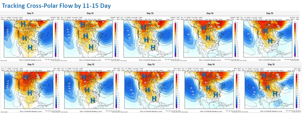
Dry and cold followed by warm and wet?I assume we still need it further east? This is a colder pattern but sure seems like the PV location is tricky.
View attachment 145205
View attachment 145204
Yeah, when you look at the anomolies it looks great but when you look at heights your like...uh oh.With the TPV as indicated is how the people east of the apps get the very cold air, question is will it also suppress the storm track and at this point it looks like it


Actually you kinda want there to be fluctuating in the positive territory on the PNA. Often times when it stays strongly positive is actually when there is legitimate suppression concerns.GEFS indices:
PNA - Going mostly positive, with a trend towards neutral in the LR. ***Would rather see this stay strongly positive
NAO - Averaging ever so slightly negative throughout. ***Have no idea if this would be a player
AO - Falling off a cliff (negative). ***You would think our side of the world will get cold
like thisActually you kinda want there to be fluctuating in the positive territory on the PNA. Often times when it stays strongly positive is actually when there is legitimate suppression concerns.


Agreed. It looked to be moving into position on most members at the very end of the 00z EPS run, but it looks to me like it would be after the 20th before we would really establish a "great" pattern for those east of the Apps, with the usual caveats of this is 15+ days away and will this ever actually happen.I assume we still need it further east? This is a colder pattern but sure seems like the PV location is tricky.
View attachment 145205
View attachment 145204
That's what has been so frustrating to me lately. We keep tracking the perfect pattern, one we only get a handful of times in a decade, but yet we usually snow most winters with some setups that frankly look like garbage. I've revisited some of the old threads from several years ago and I'm shocked -- and honestly annoyed -- at how we (including myself) were so confident in setups that ended up delivering that looked way worse than ones we've tracked recently that didn't deliver.We wasted a very far south deep ull the past couple of days and then you look at another in southern Texas and you wonder what would happen if we had just a little luck.
View attachment 145222


Is that building in cold air or retreating?
Probably a good little front end thump if it verified
Interesting. That does look like the typical winter storm in NC as far where the snow and rain line sets up.

GEPS rolling in significantly colder than last run. I'd say so, i guess, with this look:
View attachment 145228


 . But, at least the kids can use all the sleds I bought. ?


the semantics dont matter at this stage - we've maintained the signal on the OP. Lets hope we hold serve or do better on the GEFS