• Hello, please take a minute to check out our awesome content, contributed by the wonderful members of our community. We hope you'll add your own thoughts and opinions by making a free account!

Wintry February 19-21, 2020 Winter Storm

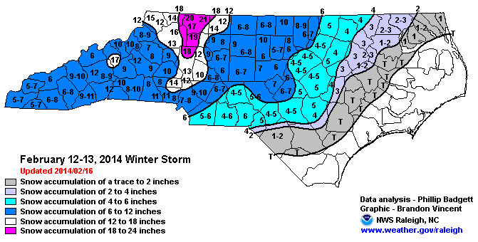
I’m not sure where you in Union County, but I’m in Wingate and I’ve said several times that I wouldn’t be surprised to see us get in on the deform band for a time tomorrow night. I’ve seen it a few times with this set up.

I am in the western part of the county. Matthews/Indian Trai area. I would love to see us get on the deform band. I am trying to recall the last time we were under one. Maybe you can provide more details on that. It would be nice to see some of the short-range modeling come in colder tonight. And I would love to see our DP's drop. Currently at 36.
 
Mike Maze at WRAL said they are expecting less than 10:1 ratios and going with the GFS and Euro ensemble means for their totals. Just think it is crazy they don't even take the short range models into account now.
 
I think the NAM is amping things up a little too much. I truly think the warm nose will happen but it won’t be as stout or last quite as long.

The funny thing about that is more times than not, if the warm nose shows up in any way with the NAM, it has generally been known to verify stronger and more stubborn to erode. @Rain Cold fix this
 
The funny thing about that is more times than not, if the warm nose shows up in any way with the NAM, it has generally been known to verify stronger and more stubborn to erode. @Rain Cold fix this
I wish I could. Never ever ever ever, and the Rock means EVER bet against the NAM warm nose.
 
The warm nose is what hurts the upstate with accumulations. Anyone that sees 2 or more inches got lucky in my opinion. I work in school cafeteria in Pickens county. 2hr delay I have to go in normal time. I’m really hoping we get enough to keep schools closed Friday. 2hr delay would just be a headache


Sent from my iPhone using Tapatalk
 
I am in the western part of the county. Matthews/Indian Trai area. I would love to see us get on the deform band. I am trying to recall the last time we were under one. Maybe you can provide more details on that. It would be nice to see some of the short-range modeling come in colder tonight. And I would love to see our DP's drop. Currently at 36.
The two that come to mind right off are December 2010 and January 2018
 
The two that come to mind right off are December 2010 and January 2018
They have the potential to put down some surprises. Remember the surprise deform that put down around 20” from Mt. Airy to Roanoke in Fab Feb 2014?

february_12-13_2014_nc_snowmap.gif
 
Everyone in upstate sc from Anderson up will have 2+ inches. The rain/snow line will be down in abbeville/greenwood area. The temps will drop much faster than the models are saying.

Cold chasing moisture is never a good scenario East of the Mountains in my experience. Cold air in place is much better for SC, that I do know.
 
Everyone in upstate sc from Anderson up will have 2+ inches. The rain/snow line will be down in abbeville/greenwood area. The temps will drop much faster than the models are saying.
Dont see that happening, if you are not in Greenville, Pickens, or spartanburg you not seeing 2" folks in those counties could see that
 
Dont see that happening, if you are not in Greenville, Pickens, or spartanburg you not seeing 2" folks in those counties could see that

Even then probably from a line from Pickens travelers rest north.


Sent from my iPhone using Tapatalk
 
Cold chasing moisture is never a good scenario East of the Mountains in my experience. Cold air in place is much better for SC, that I do know.

I dont know, I recall rain to snow (cold chasing moisture) being some of the best storms in my NC history. Snow to rain (precip over running cold air in place) seems to erode and never is fun. I'd take rain trans to snow any day times 100 over the inverse.
 
Back
Top