-
Hello, please take a minute to check out our awesome content, contributed by the wonderful members of our community. We hope you'll add your own thoughts and opinions by making a free account!
You are using an out of date browser. It may not display this or other websites correctly.
You should upgrade or use an alternative browser.
You should upgrade or use an alternative browser.
Wintry February 19-21, 2020 Winter Storm
- Thread starter Six Mile Wx
- Start date
ForsythSnow
Moderator
Only thing about that is if the situation was showing it through the entire event or it growing in midway through. This case has it going away eventually, but I'll mostly expect rain and hope the warm is wrong.My experience with soundings (have only been looking at them for the last several years, so very limited) showing a warm nose, is take the warmest sounding and expect worse. If you see that signature in graphical or text soundings, it always seems to over perform.
B
Brick Tamland
Guest
Just saw this from WRAL met Kat Cambell on Facebook.
I’ll show you the latest snowfall forecast and some exclusive model data we have here at WRAL: European model chances of 1”, 3”, 6” of snow and future road temperatures.
Why are they still using the long range Euro for totals instead of the short range models? RAH seems to be doing it, too. I don't get it.
Avalanche
Member
Surprising that thermals would allow for that today. Wow!!Wife just texted me from Wilson saying that its sleeting.
D
Deleted member 609
Guest

Nomanslandva
Member
True, this one is different in that way! I guess that is why the NAM3km gives me .1 of snow. Incoming cold is shoving this thing too far offshore for me hereOnly thing about that is if the situation was showing it through the entire event or it growing in midway through. This case has it going away eventually, but I'll mostly expect rain and hope the warm is wrong.

Sctvman
Member


ForsythSnow
Moderator
Steady for NC, but for GA and TN it's been a rollercoaster.All this talk about the NAM's amping up...they have a little. The snow/precip output has been really steady over the past 5 runs....here is the 3km.
View attachment 35684
Snow
View attachment 35685d
Stormlover
Member
from Huntsville NWS: FOR NOW, WILL BE CONSERVATIVE ON THE VALLEY SNOWFALL GIVEN THE UNCERTAINTY OF THE COOLING. TEMPS IN VALLEY AREA MAY HAVE SNOW FALLING WITH TEMPS IN THE M-U30S. WE MAY NEED TO RAMP THIS UP QUICKLY IF FORECAST SOUNDING PROFILES PERSIST IN THIS FASHION.
I see what the NAM is depicting out I think those random pockets of more precip are under those heavy deformation banding when the storm wraps around .. obviously the model can’t place exactly where they’ll be but whoever gets to be under those will see the localized way higher snow totals ... truly a fun event to now cast tomorrow
Sent from my iPhone using Tapatalk
Sent from my iPhone using Tapatalk
Ron Burgundy
Member
Interesting. FFC just added snow wording in my grid forecast (north ATL inside 285).

Steady for NC, but for GA and TN it's been a rollercoaster.
Yeah, good point. 20-30 miles going to be a big difference for everyone. I do think the northern extent of the precip shield will be further north than the NAM's have.
Ugafanofweather
Member
I wonder if they see something in other models or the soundings. Interesting to see thatInteresting. FFC just added snow wording in my grid forecast (north ATL inside 285).
View attachment 35686
I wonder if they see something in other models or the soundings. Interesting to see that
It's just going to be about how much moisture hangs around from the initial load tomorrow if the moisture train lingers into the afternoon perhaps a little juicer means when temps crash will see some areas hit by changeover nothing as of right now point to accumulations but still a few more hours of models and then now-casting
ATLwxfan
Member
I wonder if they see something in other models or the soundings. Interesting to see that
A gratuitous move probably. A flake here or there.
Will be interesting to see what the next WRF model run shows though.
Sent from my iPhone using Tapatalk


Ron Burgundy
Member
Huntsville referenced the soundings in their AFD as to why they may have to get more bullish, so I imagine it’s the same for FFC. Given the way the moisture has ramped up for the I-20 corridor in the latest model runs it wouldn’t take much to create a decent event if the thermals ticked colder. But I must not allow myself to believe.I wonder if they see something in other models or the soundings. Interesting to see that
LovingGulfLows
Member
- Joined
- Jan 5, 2017
- Messages
- 1,499
- Reaction score
- 4,100
The sleet accumulation pictures from the Carolina board members will be fun to see.
ATLwxfan
Member
Cool how the SLP climbs to about ILM and pivots east. Some band is going to rake someone when that happens....probably NE 95 corridor over to PGV.
View attachment 35688
Verbatim that’s snow to ATL. Just tells me models are struggling with the details especially in the fringes.
Sent from my iPhone using Tapatalk

Sctvman
Member
Cool how the SLP climbs to about ILM and pivots east. Some band is going to rake someone when that happens....probably NE 95 corridor over to PGV.
View attachment 35688
That has it ending as snow through the CHS area and almost to SAV.
Shaggy
Member
Cool how the SLP climbs to about ILM and pivots east. Some band is going to rake someone when that happens....probably NE 95 corridor over to PGV.
View attachment 35688
MHX seems to think we stay liquid most of the day only changing over later tomorrow evening. They give us 2 to 3.
As of 250 PM Wednesday...The calm before the storm on Thursday.
Low pressure develops off the northeast Florida coast and moves
offshore well to our SE while strengthening Thursday. NAM3km/HRRR
shows light rain returning to the CWA by mid-morning Thursday
with steady light rain continuing through the daylight hours.
Top- down ensemble precipitation type tool indicates that ptype
should remain liquid through 00z and surface temperatures remain
at 36 degrees or higher over the northwestern corner of the CWA
and closer to 40 degrees elsewhere. Highs will likely occur
around midday with slowly falling afternoon temperatures. N/NE
winds will remain gusty on Thursday.
FFC made a special weather briefing.
D
Deleted member 1449
Guest
The happy hour GFS is looking more amped from before. Maybe it's catching on.
Edit: it still works like a vacuum.
Edit: it still works like a vacuum.
Last edited by a moderator:
dexter fishpaw
Member
Light sleet in North Raleigh (North Hills)
They are certainly more bullish than they were in the morning discussion. Latest SREF is not good, NAM12k still good, NAM3k pretty low.Huntsville referenced the soundings in their AFD as to why they may have to get more bullish, so I imagine it’s the same for FFC. Given the way the moisture has ramped up for the I-20 corridor in the latest model runs it wouldn’t take much to create a decent event if the thermals ticked colder. But I must not allow myself to believe.
well after this winter seeing this on the radar will be a win everyone will take no matter if you get a trace or 3"+.

Could be covering their tail from the last storm we had a couple weekends ago. In the previous post of mine I’ve said all along that this so close for north Georgia. Rome to canton to Gainesville ( I think it was the nam that started seeing within 12 hours that we were going to get more than a dusting because all the local news were saying a dusting ) I do think this storm will have some surprises. The heavier rains could actually pull the temps down and change it to snow and I think that’s what they are seeing as cold air continues to come inI wonder if they see something in other models or the soundings. Interesting to see that
Well RAP 850s at hour 21 are colder than NAM for what its worth.
Not sure if you're aware, but the link you posted isn't showing up. At least on my computer.
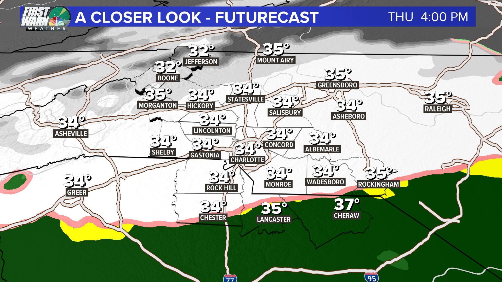
wcnc futurecast tomorrow at 4. i'll take this. latest nam holds off our changeover until after 5pm though.
WxBlue
Meteorologist
Seems like snow/rain line is finally being steady on models now... good news for folks along US 64/ US 264 corridor.
Stormlover
Member
SREF is starting back up..has a mean of 1.21 for Chatt and 6 members over 2 inch..for Meridianville the mean is back over half an inch, a good bit more than the airportThey are certainly more bullish than they were in the morning discussion. Latest SREF is not good, NAM12k still good, NAM3k pretty low.
In the past this model has often showed rain where Brad P. would be forecasting snow, and he would dismiss the solution as having a warm error. It’s good to see this model having the changeover complete at 4 for the whole metro area. There should be another 6-8 hours of precipitation after this.wcnc futurecast tomorrow at 4. i'll take this. latest nam holds off our changeover until after 5pm though.
In the past this model has often showed rain where Brad P. would be forecasting snow, and he would dismiss the solution as having a warm error. It’s good to see this model having the changeover complete at 4 for the whole metro area. There should be another 6-8 hours of precipitation after this.
Yeah, that looks great for the whole Metro and it looks to be coming down hard. But if that map comes to fruition, you would think he would up his totals some. For people like us in Union County, it's so close to that dreaded rain line.
ajr
Member
Is there a link to actual sounding data now that we’re getting into now casting?
I’m not sure where you in Union County, but I’m in Wingate and I’ve said several times that I wouldn’t be surprised to see us get in on the deform band for a time tomorrow night. I’ve seen it a few times with this set up.Yeah, that looks great for the whole Metro and it looks to be coming down hard. But if that map comes to fruition, you would think he would up his totals some. For people like us in Union County, it's so close to that dreaded rain line.