• Hello, please take a minute to check out our awesome content, contributed by the wonderful members of our community. We hope you'll add your own thoughts and opinions by making a free account!

Wintry Feb 2-4 2022 Winter Weather Potential

Looks like 4-8 from the TV stations here the NWS didn't really say anything other than 7-10 is their high end and they said they were conservative but I think the sleet uncertainty 4-8 makes sense could be a lot more if it's all snow
 
Looks like 4-8 from the TV stations here the NWS didn't really say anything other than 7-10 is their high end and they said they were conservative but I think the sleet uncertainty 4-8 makes sense could be a lot more if it's all snow
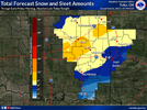
I’m thinking more snow and less sleet for you compared to where we were yesterday. Most models have shown a little bit colder upper levels. In terms of totals this is what I think right now for our areas:
OKC: 3-7 inches
Tulsa: 6-9 inches
 
I’m thinking more snow and less sleet for you compared to where we were yesterday. Most models have shown a little bit colder upper levels. In terms of totals this is what I think right now for are areas:
OKC: 3-7 inches
Tulsa: 6-9 inches

Yeah I'm definitely leaning higher side with today's trends hopefully it keeps up

I do understand being conservative though
 
One thing I am interested in watching tomorrow is how the front is progressing. Right now most models show OKC and Tulsa getting below freezing by 12z-15z, but I wouldn’t be surprised if that actually happens a few hours earlier like around 09z. Last year played out similarly as the cold air filtered in several hours earlier then originally thought. This could mean earlier onset of freezing rain Wednesday morning.
 
One thing I am interested in watching tomorrow is how the front is progressing. Right now most models show OKC and Tulsa getting below freezing by 12z-15z, but I wouldn’t be surprised if that actually happens a few hours earlier like around 09z. Last year played out similarly as the cold air filtered in several hours earlier then originally thought. This could mean earlier onset of freezing rain Wednesday morning.

Seems to always happen the models are always too slow
 
Back
Top